If you plan on climbing Tofana di Rozes via its normal route, here is my first-hand report. I did it solo during the first week of July, so this is a summer ascent report.
I like to start from the end. Right after climbing Tofana di Rozes, I was admiring the mountain from the Passo Falzarego (2117 m, 6945 ft), and it was quite hard to believe that earlier that same morning I had been on its summit.
Here’s how it looked from this already quite high viewpoint; the summit is partly in the clouds. The road you can see below leads to Cortina d’Ampezzo.
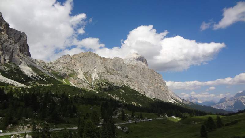
The mountain looks impressive from every side, and on a sunny day its summit looks white. However, this is due to a large amount of loose rock and not to snow, at least during the summer.
Access roads & coordinates
Tofana di Rozes rises to the west of Cortina d’Ampezzo, and this is the closest town for supplies. The mountain belongs to the Dolomites, Province of Belluno, Veneto, Italy.
This is the most popular of the three peaks in the Tofane group, the other two being Tofana di Mezzo (3244 m, 10,643 ft), and Tofana di Dentro (3238 m, 10,623 ft). So if you want to enjoy the summit in solitude, it is best to start very early and to definitely avoid weekends.
If you are coming from the direction of Cortina d’Ampezzo, finding the road out of the city can be a bit tricky. Therefore, follow the signs for Pocol and Falzarego pass. After Pocol, you will see the road to the Dibona hut on the right. At this point you are still in the woods.
Note that this is a narrow asphalt road for the first part, but the last 4 kilometers are unpaved (macadam). It is not in the best condition, but many people use it, so you can do so as well.The AllTrails map below shows all the details. If you follow the link, you will find more.
Tofana di Rozes numbers & details
- Coordinates, latitude & longitude: 46.53735° N; 12.05087° E.
- Elevation: 3225 m (10580 ft).
- Normal route difficulty: walk-up.
- Height difference to climb from the car parking: 1142 m (3746 ft).
- Time necessary to climb from the car park: 4–5 hours, but this depends entirely on your fitness and pace.
- Useful map: Cortina d’Ampezzo e Dolomiti Ampezzane, Tabacco, 03, 1:25000.
- Places to sleep: Angelo Dibona hut, Camillo Giussani hut.
The routes
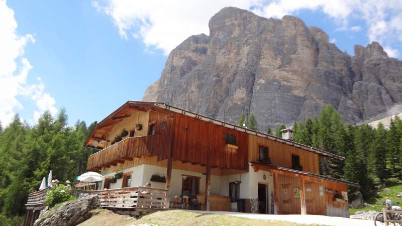
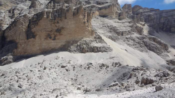
There are two main normal routes to the summit, and in principle they both start from the Rifugio Angelo Dibona parking where you have relatively high car access. The picture below shows how the hut looks, and behind you see the wall of Tofana di Rozes; the summit is not visible here. The elevation of the parking is 2083 m (6834 ft).
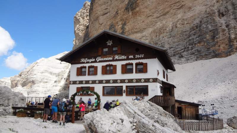
From the car parking at the Dibona hut, you follow the route that leads to Rifugio Giussani (the picture below) which is at an elevation of 2600 meters (8530 ft). This is the same direction for both routes.
So if you want to stay the night in a hut and then continue the next morning to the summit, you can use either of these two huts. But note that there is an elevation difference of around 517 m (1696 ft), and trust me — this is a lot.
The picture below shows the pass which should be your direction; this is above the Dibona hut and the route zig-zags in the direction of the Giussani hut. I took the picture while descending.
Note that there are also some other possible starting points from the south-west direction; you can find them easily on the map mentioned above.
1. The first route is the Giovanni Lipella via Ferrata
I did not go that way so I cannot say much about it. Here on the site, I only describe the routes that I have climbed myself, so that I can provide reliable first-hand information.
The reason for not going that way was that I was not sure about possible snow in narrow gullies and on galleries. One dangerous passage can ruin the day; you can read about such an experience in my text about Jof Fuart.But you can get some feeling from this great video below. You will see two young people who were climbing it a few days before my own climb.
You will also see that they had to give up just below the summit because of rain and lightning concerns. At that point, they did not need more than 25 minutes or so. I must say, I admire the fact that they were so rational; it may be very hard to give up when you are so close.
2. The second is the normal walk-up route from the Giussani hut or from the car parking
So from the Dibona hut go in the direction of the Giussani hut. The direction should be obvious and visible from the car parking.
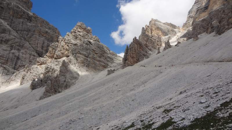
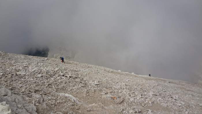
At the Giussani hut, when you are alone in the morning, it can be easy to miss the direction. I made this mistake, and I have seen other people doing the same later when I was descending from the summit.
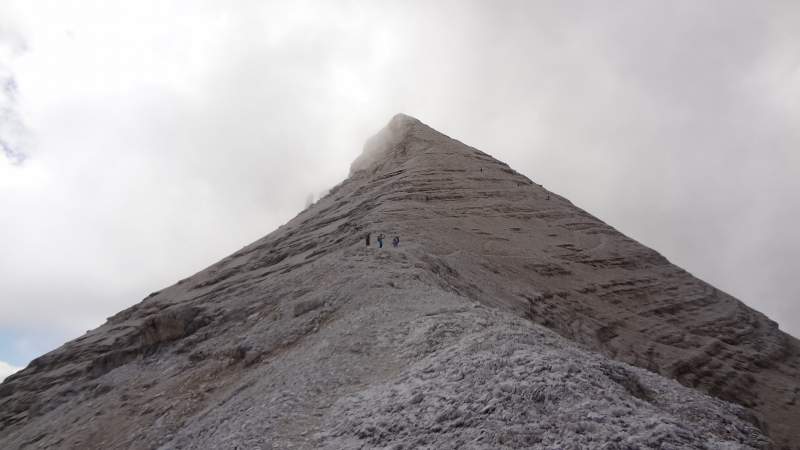
Namely, I went up in the picture shown below. The reason is that there is some path visible in the scree, but when you get there you will find yourself on ledges and realize that this is not the route. What you have to do is to go diagonally in the west direction.
Later during the day, you will see a long line of people going up and the direction may look obvious, but trust me — this is not so in the early morning.
So you will approach the summit ridge from the north-west side. This is just the opposite to the direction of the Dibona hut, which means you have made a half-circle loop around the mountain. At one point, you will come to the place on the ridge where the previously mentioned ferrata route joins your route.
My climb
I slept in the car on the parking; I have seen several other people doing the same. At 5:05 AM, I was on my way up and arrived at the Giussani hut at 6:35 AM. I did not stop there and just continued.
At some point, as mentioned above, I lost the route and spent some time trying to get back and find the correct path. Eventually all was fine and I was on the summit at 9:35 AM.
All in all, this was in 4 hours and 30 minutes, not so bad for the first mountain in the season. But do not ask me about my muscles the day after. There were only two people on the summit, a father and a son, who passed me at some point below on the route.
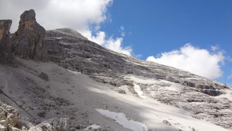
The weather was perfect, but this was so only in the morning. When I saw the north-west summit ridge in front of me, I knew this would be a successful day. See what I saw:
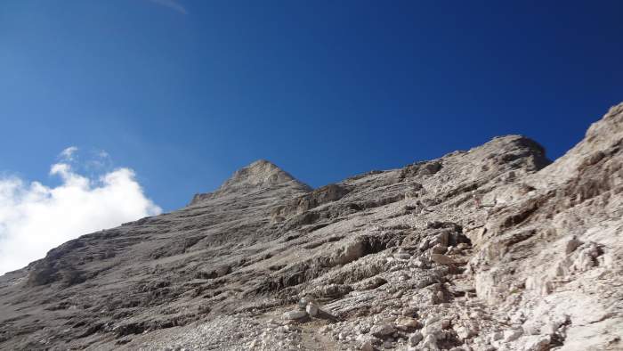
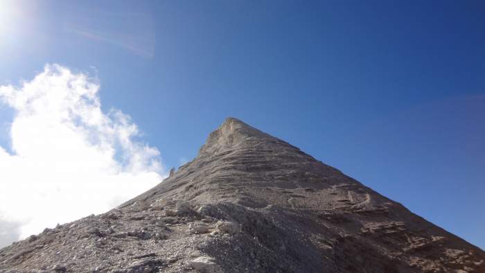
Note that below the summit, in the third photo above, you can choose to follow the ridge or you can go to the right and approach the summit in an anti-clockwise loop. I chose the latter, but it was a bit icy in the early morning and cold. It is better to follow that beautiful ridge; you might be in the sun all the time.
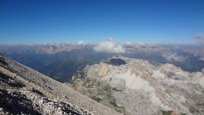
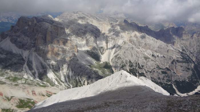
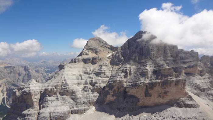
On the summit, I had a period of clear views around. See the other two peaks from the Tofane group:

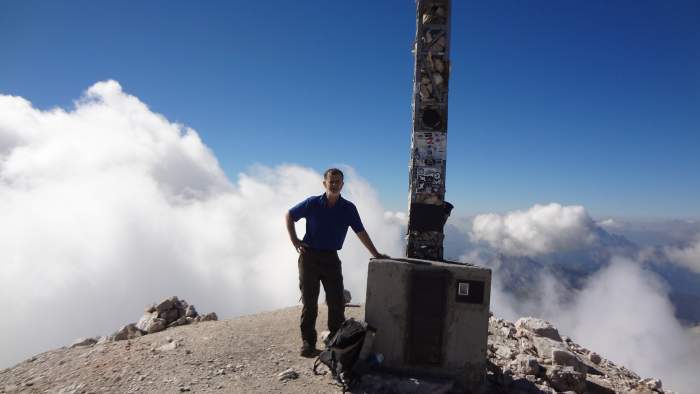
I had my morning coffee on the summit. I carry my MSR Pocket Rocket stove and a sports-copy of a Bialetti pot, and I enjoyed it for half an hour or so before some other people started arriving.
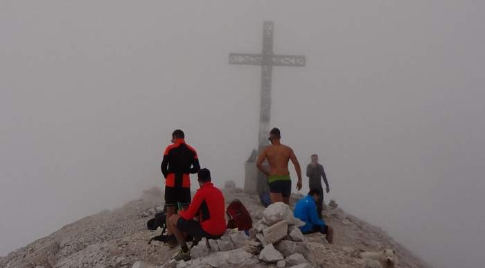
But at some point clouds came. Here is one moment I captured just as I was about to go back. It was not warm on the summit at all, but as you see some would disagree:
On the way back, the weather improved. See some details in the pictures below. The first picture shows the place where the ferrata route (coming from the left in the picture) joins the other normal route; this is at around 3027 m (9931 ft) of elevation.
Equipment, supplies & accommodation
The normal route I followed requires no special equipment. But this is not the case for the mentioned Lipella route. So you can use any hiking boots; it is always best to have good ankle support.
I had my Salomon Quest Prime GTX boots, and I used the Osprey Stratos 24 pack which is perfect for such a day tour. I always carry all waterproof layers, plus gloves. I can tell you, I needed them two days later on my climb of Piz Boè.
I also use a pair of trekking poles; on this occasion I had a pair of Komperdell poles, but this is up to you. It can be hard without sunglasses, so make sure you have them with you, plus a hat, and some sunscreen.
There is no running water around in the summer months, so carry it unless you want to buy some at the Giussani hut. I had two liters and this was enough.
The same holds for food. You can have everything in the two huts; otherwise carry it in a daypack.Orientation should never be a problem, except for the small episode mentioned previously.
Accommodation: This is a popular area but there are many options to rent an apartment or you can choose any of the camping spots around.
Final thoughts
So this was my report of climbing Tofana di Rozes. This is a beautiful place, and it is not surprising that it is so incredibly popular. Technically, the route I followed is a walk-up type without exposed sections.
But this is a high mountain and you will feel the altitude. The oxygen concentration at its summit is around 14% as compared to 20.9% at sea level. So this is a reduction to around 62% of its normal sea-level value. Note that you can also make a round tour if you do not wish to go to the summit, or if the weather is not on your side.
On my way back I met tens and tens of people going up, and I was surprised at how inappropriately some of them were dressed. Also, they were going up when it is normally the time to get off the mountain.
These are some of the reasons for tragedies that sometimes happen. Just one day later, there was one huge one on the nearby Marmolada mountain. I wrote a short text about it; you can read it here.
You might also want to read my report from climbing Piz Boè which is not far from this place.
So I stop here. Thank you for reading. You might also want to read my text about Sasso Piatto which is in the same area.
Please join us at our Facebook group Dolomites Visitors Hub. Let me know if you have questions or comments; there is a comment box below.
FAQ
What is the best time of year to climb Tofana di Rozes?
The optimal time for climbing Tofana di Rozes is from July to October, when the weather is generally stable, trails are free of snow, and daylight hours are longer for safer ascents.
Early summer (May to June) can still have lingering snow patches on northern slopes, which may require ice axes or crampons for some routes, while late autumn brings cooler temperatures and a higher risk of early snowfall.
Winter climbs are feasible for experienced mountaineers with proper ice gear, as the Tofane group transforms into a premier ski touring destination, but avalanche risks must be carefully assessed.
Is a permit required to climb Tofana di Rozes?
No permits are needed to climb Tofana di Rozes, as the mountain is accessible via public trails in the Dolomites. However, if your climb involves staying overnight in mountain huts like Rifugio Dibona or Giussani, advance bookings are advisable during peak season to secure a spot.
Additionally, since the area is part of the Ampezzo Dolomites Natural Park, a UNESCO World Heritage site, visitors should adhere to Leave No Trace principles to preserve the environment, and check for any seasonal closures due to wildlife protection or maintenance.
What is the historical significance of Tofana di Rozes?
Tofana di Rozes holds notable mountaineering and military history. It was first ascended in 1864 by Austrian alpinist Paul Grohmann accompanied by local guides Angelo Dimai, Santo Siorpaès, and Francesco Lacedelli, marking an early milestone in Dolomite exploration.
During World War I, the mountain was a strategic frontline between Italian and Austrian forces; in 1916, Italians excavated a 507-meter tunnel beneath the Austrian-held Castelletto formation and detonated 35 tons of explosives, obliterating part of the defenses in a dramatic operation.
Today, wartime relics such as trenches, caves, and tunnels remain, with some incorporated into via ferratas, providing hikers a tangible connection to this turbulent past.
What other activities are available near Tofana di Rozes?
Around Tofana di Rozes, adventurers can enjoy a variety of pursuits beyond the normal route. The south face offers world-class rock climbing with multi-pitch trad and sport routes ranging from moderate to extreme difficulties (up to UIAA VI), attracting climbers globally.
Hiking options include scenic circuits like the full loop around the mountain via Val Travenanzes and the historic Scala del Minighel ferrata.
In winter, the area excels in skiing, snowshoeing, and ski mountaineering. Nearby Cortina d’Ampezzo serves as a hub for additional activities such as mountain biking on forested trails, paragliding over the valleys, and visiting cultural sites like WWI open-air museums.
gary says
Another great report well done,i think a seed has been planted…again 🙂
Jovo says
Thank you Gary, this is a really great summit, I was enjoying watching it from several different mountains and passes around after my climb.