If you plan to climb Piz La Varella from Capanna Alpina, here is my first-hand report with the route description and all the other details you might need. So keep reading.
The mountain has many different name versions, as you will see below in the basic data. I use the name written on the summit cross, i.e., La Varella. You can climb this mountain together with the nearby Cima Conturines, which is 9 meters higher. You will see a photo of it below.
Quick facts
- Name versions: La Varella, Lavarella, Lavarela, Piz La Varella.
- Coordinates, latitude, longitude: 46.58510° N, 11.97110° E.
- Normal route type: walk-up.
- Elevation: 3055 m (10022 ft).
- Huts: Capanna Alpina (1720 m, 5643 ft); Rifugio Fanes (2060 m, 6759 ft).
- Map: Cortina d’Ampezzo e Dolomiti Ampezzane, Tabacco, 03, 1:25000.
- Towns for supplies: San Cassiano, Cortina d’Ampezzo.
Access
Below is a zoomable map so you can see the larger and smaller areas, with all access roads as well as the climbing paths. I have very roughly marked the route with the line in three different colors.
Route description
From what I have seen, the mountain can be approached from various sides and climbed by several routes. Here I describe only the route that starts from Capanna Alpina, the one I have climbed myself.
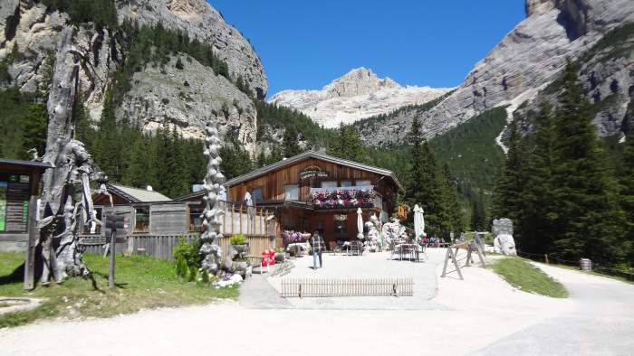
There is a large paid car park at Capanna Alpina. It was empty when I arrived, but full when I returned. The photo of the Capanna below was taken on my way back.
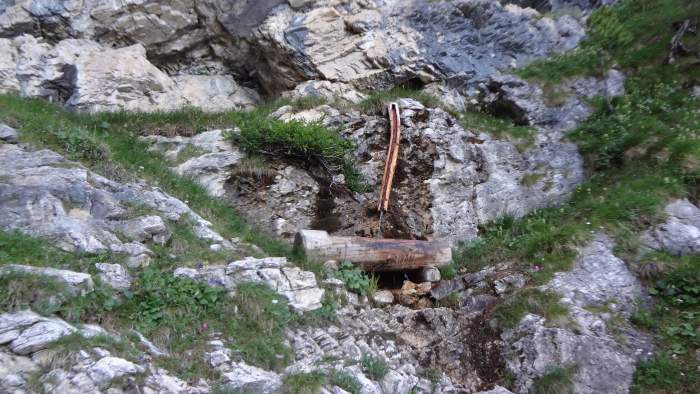
From the parking continue in the north-east direction through the forest. This is the direction towards Col de Loccia (2069 m, 6788 ft), visible in the picture above directly above the Capanna. Just below the Col there is a water source. I do not know if the water is available all year round.
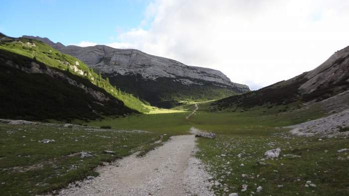
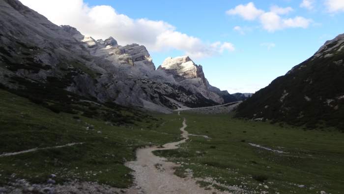
The path is very gentle at first as you go through the woods, then it becomes steep before you reach the Col. After that you reach a very pleasant, more or less flat section at high elevation. Here, you are already above 2000 meters. This area is called Le Gran Plan. The path rises very slowly towards Ju dal’Ega pass (2157 m, 7077 ft) seen in the picture:
This is how it looks when you look back. It was still rather early and the colors are not the best:
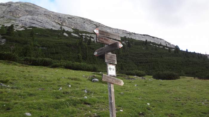
At the highest point of this section you will find a sign with many directions. Turn left here in the direction of Lake Conturines (2518 m, 8261 ft).
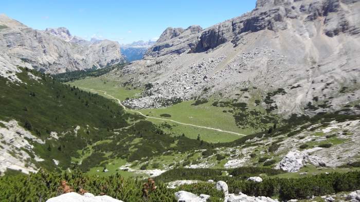
You start gaining altitude and the route becomes more demanding. After about half an hour you will have Ju dal’Ega pass below you as in the picture:
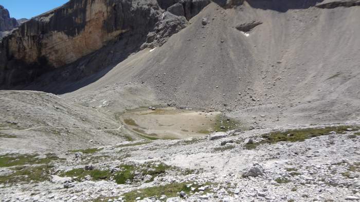
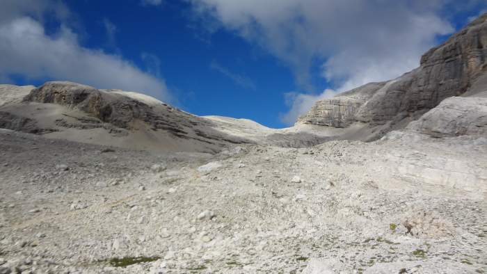
I was there early in the season and there was no lake at all, just an empty hole as you see in the picture below. From this area all the way to the summit it is pure rock, and there are no water streams around.
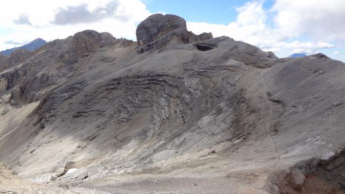
You go to the right from the “lake” and up towards the pass you see in the picture below. This part of the route is very well marked. The summit of Lavarella is on the right but not visible in the picture.
Below you see the same pass when you are on the final slope to the summit. On the left is the summit of Conturines. So when you are on the way back from Lavarela, you can continue to Conturines. The path is visible here:
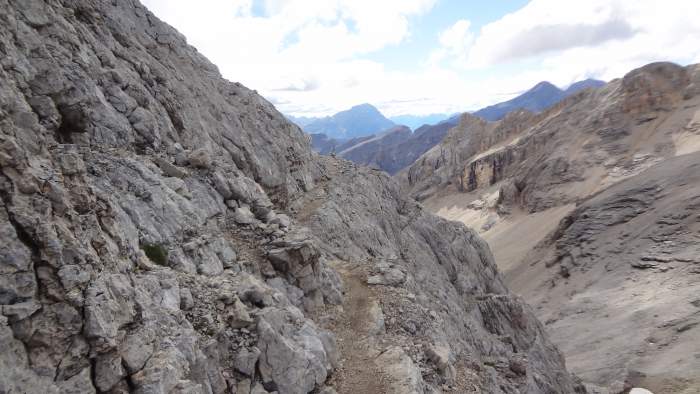
The final summit slope is easy to climb. There are just a few simple passages where you should be a bit more careful. One is shown below:
From this part you will see most of the route below. Here is the view of Lake Conturines:
The last part below the summit of La Varella is shown in the picture:
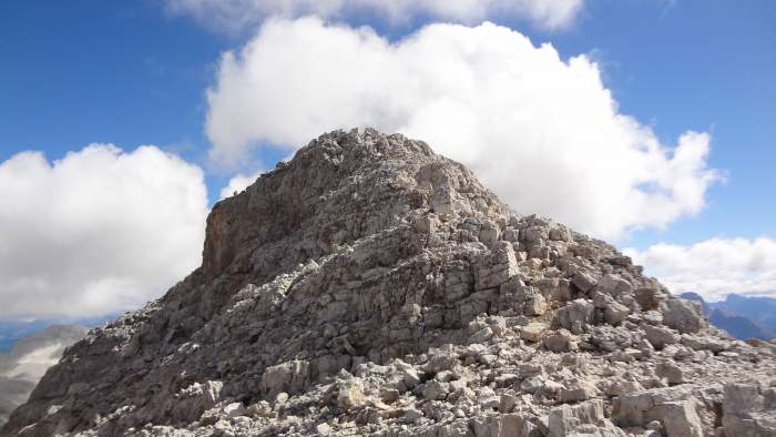
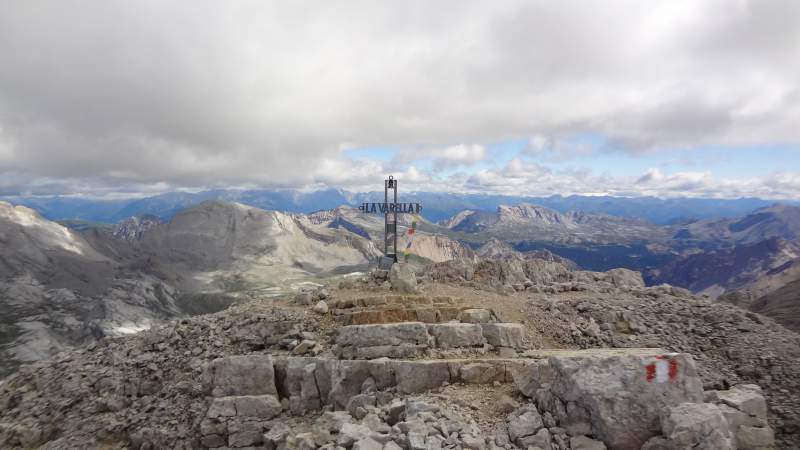
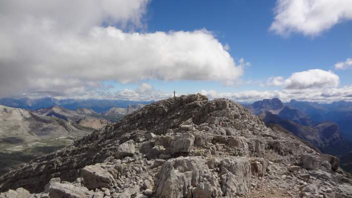
After that you will see the summit cross on the pleasant and long summit ridge without any difficult sections:
My climb
I came from Arabba over Falzarego Pass and parked at the car park next to Capanna Alpina (the fee was 5 euro per day). I started walking relatively early, at 5:55 AM. There were no people around at all.
After around 90 minutes I reached the sign at Ju dal’Ega pass. I arrived at the summit at 10:25 AM. That makes 4 hours and 30 minutes. The total elevation gain is 1335 m (4380 ft), and the route goes uphill the whole time.
I had the feeling my progress was slow, and I did not push at all. In fact I felt the altitude quite strongly. So I am sure most people can do it in more or less the same time or faster.
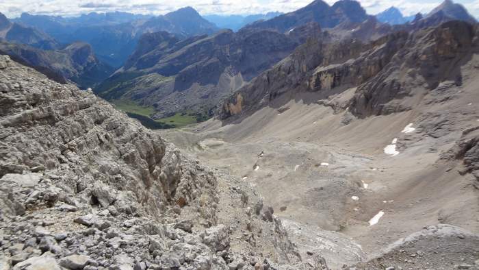
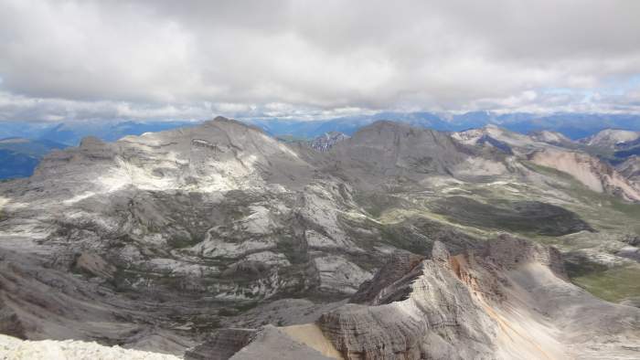
The picture below shows the Fanes plateau as seen from the summit of La Varella. This is a beautiful area with several 3000-meter peaks on the left. The whole area is a national park. The peaks include Cima Nove, Cima Dieci, Monte Cavallo, Sasso della Croce, and a few more. They are all presented here in the site.
On the right, not visible in the photo, there are two other huts from where you can climb La Varella: Ücia Lavarela (Lavarela hut) and, close to it, Ücia de Fanes (Fanes hut). You can locate them on the interactive map above.
They are at high elevation, 2042 m and 2060 m respectively, but car access is only possible to Pederù hut (1548 m, 5079 ft). From there it is a long walk to these two huts.
In the upper part of the climb it was windy and unpleasant. I normally have my morning coffee on the summit, so I brought my coffee pot and my MSR stove.
But it was cold and uncomfortable, so I did not have coffee on the summit. I had it on the pass below the summit, shown in one of the pictures above.
On the way up, just below the summit, I met an Italian woman who was descending. She was the only person I saw all the way up. She said it was windy on the summit, but she was very lightly dressed.
The situation was completely different on the way back. I met quite a number of people going up. A couple continued to the nearby Lavarela de Fora (3034 m) peak which is marked in the map above. It is not very prominent, easy to miss, but it is very close to the route. So I made a short detour and walked up to its summit.
Equipment
The normal route on this mountain is very similar to what I experienced two days earlier on Sasso Piatto. You do not need any special equipment. Normal hiking boots are fine, together with a day pack.
I used my Salomon Quest Prime GTX boots and Osprey Stratos 24 pack.
Do you need a guide?
As you can see, I walk solo, but I have been doing this for 40 years already. If you have some mountaineering experience, you can do this tour too.
However, if you want to play it safe (which I strongly recommend), get in touch with some experts and guides who can help you.
Final thoughts
In summary, I had a great day climbing Piz La Varella although it was surprisingly cold and windy. You have seen my timing. I was not in the best shape, so this is a realistic time for most people. I have included this mountain in my list of best mountains to climb in the Dolomites without special equipment.
Just make sure you are well informed about the weather to avoid unpleasant surprises. I always carry full waterproof equipment with me, no matter what the forecast says.
During this trip to the Alps I climbed several other mountains. You can read about my tours to Tofana di Rozes, Piz Boe, and Sasso Piatto. I was in the area again very recently and climbed Cima delle Nove, so follow the link to read the report.
Please join us at our Facebook group Dolomites Visitors Hub. Thank you for reading. There is a comment box below, so feel free to leave questions or comments.
Frequently Asked Questions
When is the best time of year to climb Piz La Varella?
The best period to climb Piz La Varella is typically from late June to early October, depending on snow conditions. Early in the season, snow patches may still be present near Lake Conturines and on shaded slopes, while late summer and early autumn usually offer the most stable conditions.
July and August provide the longest daylight but can also bring afternoon thunderstorms, so early starts are recommended.
Is Piz La Varella suitable for hikers without scrambling experience?
Yes, the normal route from Capanna Alpina is suitable for hikers with solid alpine hiking experience and good fitness. While there are a few steeper and rocky sections near the summit, no technical scrambling or via ferrata equipment is required.
However, comfort with exposed mountain terrain and basic route-finding skills are important, especially in poor visibility.
How much water should you carry on the climb?
You should plan to carry enough water for the entire ascent and descent, especially in dry or hot conditions. After the water source below Col de Loccia, there are no reliable water points higher up on the route.
A minimum of 2 to 2.5 liters per person is advisable, more if you are sensitive to altitude or hiking in midsummer.
Can Piz La Varella be combined with other peaks or hikes?
Yes, Piz La Varella is often combined with nearby Cima Conturines, which is slightly higher and reachable via a visible path from the saddle between the two peaks.
The Fanes–Senes–Braies Nature Park also offers numerous options for extended hikes or multi-day tours using the surrounding huts, making the area ideal for experienced hikers looking to explore more than a single summit.
Leave a Reply