If you plan climbing Monte Vioz, here you have the report from my climb directly from Peio without staying in the hut.
Basic data about Monte Vioz
- Coordinates (lat/lon): 46.40120 °N / 10.62480 °E.
- Elevation: 3645 m (11959 ft).
- Elevation difference: 2045 m (6709 ft).
- Mountain range: Ortles – Cevedale group, Italian Alps.
How to get there
If you plan to climb Monte Vioz by following the normal route, you will have to go to Peio. The Peio valley can be reached from the west over the Tonale Pass or from the east and this means either Bolzano or Trento. In the past, I have driven from all these directions, but this time I arrived over the Gavia Pass and Tonale Pass. So if you follow the same road, to know that it is incredibly narrow in the section from the Gavia Pass to Ponte di Legno.
You can inspect all the access roads in this zoomable map. If you need any information, just let me know, I have been there many times.
My tour
This was my first climb in the time of the Coronavirus, and the test of my own capabilities after being sick from COVID-19 for more than 5 weeks in the period March-April 2020. When I saw the mountain from the valley, my first thought was that I would not be able to do this. I did not feel great, and also had a feeling that a part of my lungs was missing due to the recent virus sickness.
I arrived the evening before the climb and I was staying in a nearby valley. So next morning I set off quite early and was in Peio around 5 AM. Peio is a village high above the valley (at around 1600 meters above the sea level), and with very narrow streets. I tried to find any street that would take me above the village to get some higher starting point, but could not find any.
There were no people around, it was too early, and I could not ask anybody. There are no signs for the mountain or any other hiking route. So I left the car in the free parking in the center of the village and then started walking. Eventually, I found a narrow street up and this was the right direction.
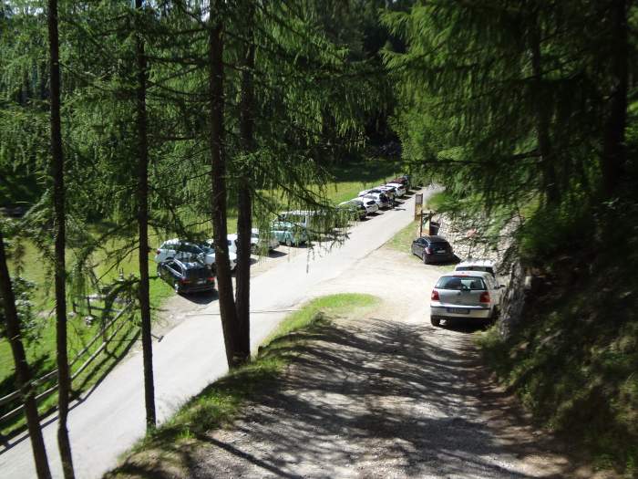
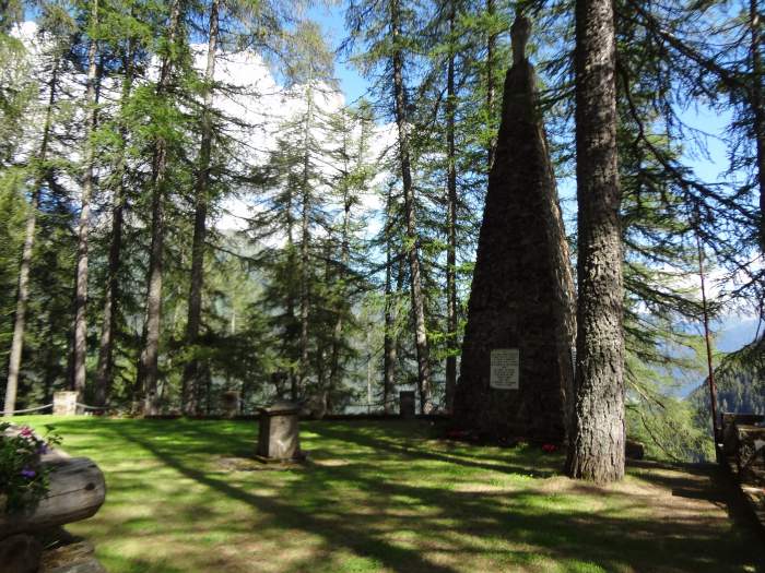
After some 15-20 minutes, I realized there was indeed a small parking higher above the village. To avoid my mistake, if you are there for the same reason, drive in the direction of the church, then turn up left. There will be a small hotel (San Rocco, if I remember correctly) on the right. Continue along the narrow street and you will arrive at free parking that is very close to the cemetery of the Austro-Hungarian soldiers from WWI. The picture below shows how this looks, it was taken after I descended the mountain.
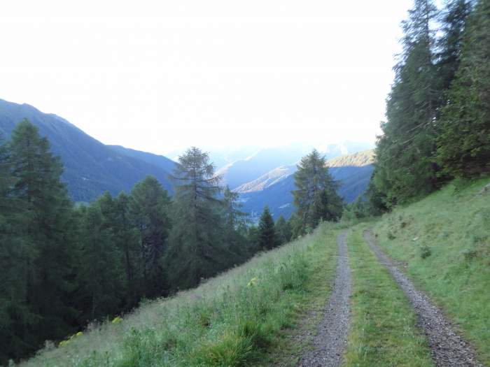
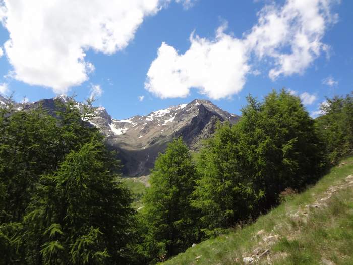
At this place, you will see the first sign for the Monte Vioz hut. So again, when you are in Peio, take the direction north-west and this will get you above the village and you will find yourself at the parking shown above. After that, you will follow a pleasant road through the woods, roughly in the north-east direction. The road is not for public use. Occasionally, you will have the view of the Peio-Cogolo valley below, see the picture.
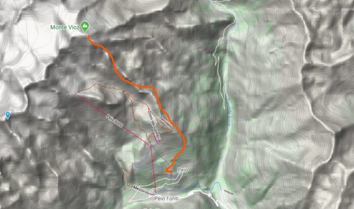
So just keep walking, you will pass a cow farm, and there will be signs for the hut. I have marked the route on the map shown below, it depicts the direction very roughly:
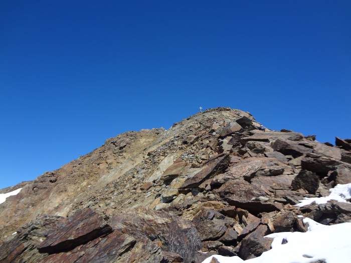
When you are above the tree level, you will be able to enjoy the views. The Monte Vioz hut (also known as Rifugio Mantova de Vioz) will be visible at some points, but it is best not to look in that direction because it looks so high and unreachable. It is on the top of the sharp peak visible in the picture:
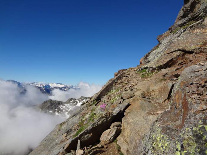
There are steep sections below the hut, but this is all the time just a walk-up, the route is well marked and you will always know where you are. The following pictures show how this looks:
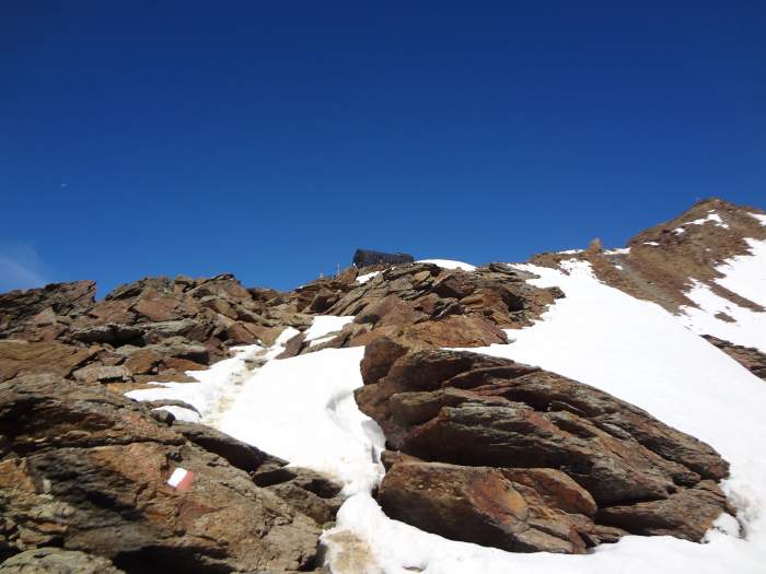
The picture below shows the hut when you are already very close to it, a few snow passages are not problematic to pass.
I did not enter the hut, in the time of the virus it is best to avoid crowded spaces, and the hut was indeed crowded, with many people sitting also outside of it. The day was great after several days of heavy rain, and it was Sunday, so the mountain was full of people.
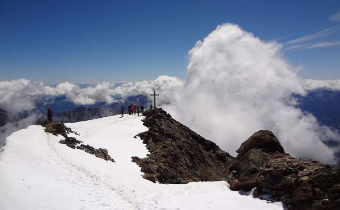
Below you see the summit cross, this is the view from the hut. The actual summit is a bit farther and higher, it is not visible from the hut.
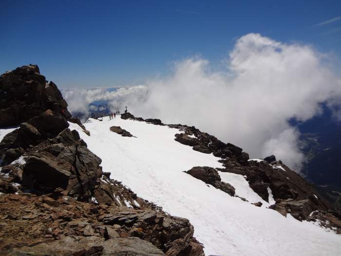
The picture below shows the hut as seen from the summit cross, it is at a stone throw. I felt a bit dizzy, but this is normal for such high mountains, and this was my first day in the season at such altitudes.
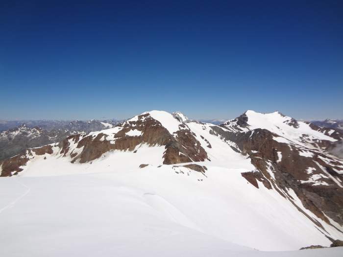
Here is the view from the true summit towards the summit cross:
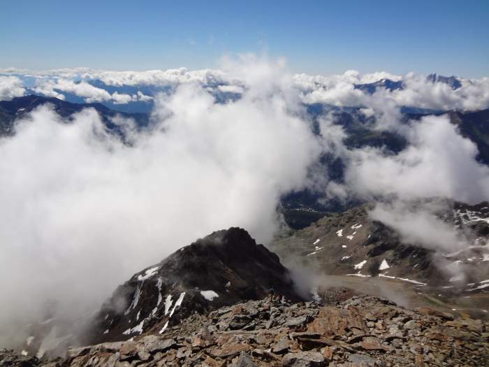
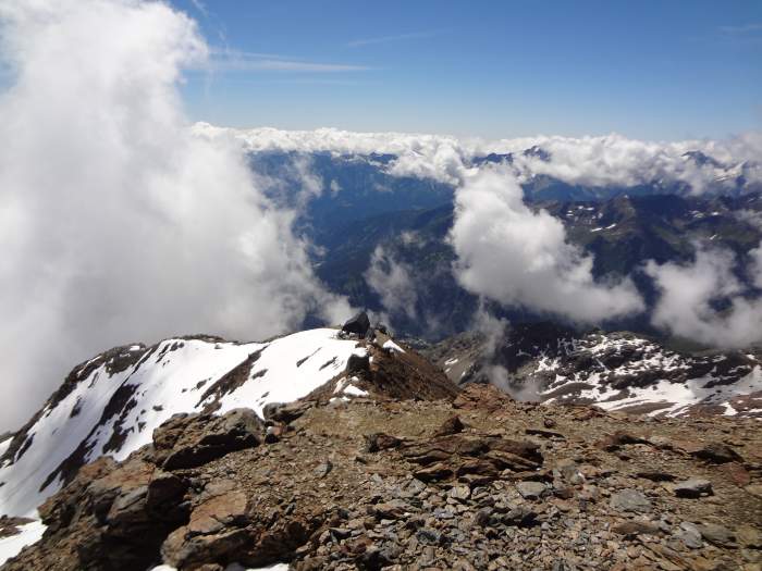
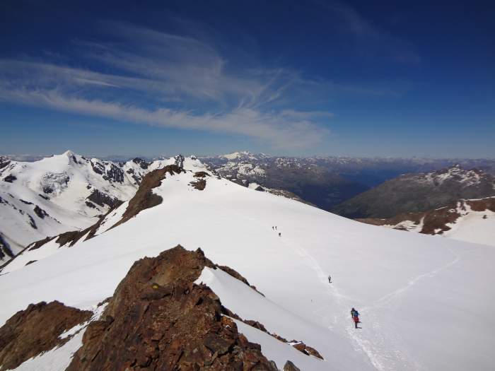
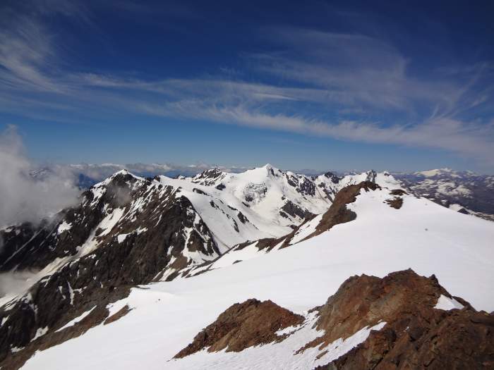
The north and west sides of the mountain are completely glaciated, below is the view of the summit plateau. On the west side, this continues into the Forni glacier (Ghiacciaio dei Forni) that is easily approached from the Valle dei Forni, i.e., from the Bormio area. You can see more in my text about the Pizzini hut and also in the page about Cima Solda. Here are a few photos from the summit:
What type of equipment is needed
As usual, I had too much stuff. But there was some logic in this craziness. When I arrived it was raining for many hours, all night and the day before. Obviously I did not know the situation on the mountain, and there was a chance of fresh snow, I have experienced this previously on my tour to Cima Solda that is not far from Monte Vioz.
But in normal summer conditions, this is just a walk-up. There are a few fixed cables but you will not use them at all, and you do not need any ferrata equipment. A few days later I climbed Cima de Piazzi which is lower but much harder, just to know if you have plans to do the same.
In the area above the hut (Rifugio Mantova de Vioz), there is a bit of snow but you normally do not need crampons (well, I did carry them). This area is normally under the snow in July, but it is easily passable.
I was carrying my new Osprey Stratos 24 pack shown below, this was on purpose, to test it in such a day tour. I was able to put everything inside and in its two pockets. For a day tour of this type, such a pack is perfect size even if you carry too much stuff like me. In the left pocket you can see my Petzl crampons, and in the right pocket is my Pure2Go water filter.
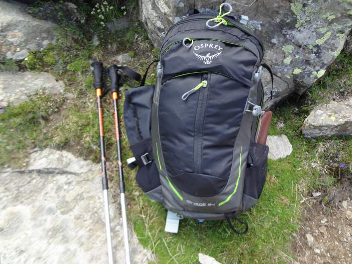
You can see also a pair of Komperdell poles that I had with me. Yet another piece of equipment that I used for testing was my Scarpa Triolet GTX Boots. This was overkill, not necessary for such a climb but I needed them for my hybrid-type crampons. In fact, I have seen many people in low cut hiking shoes. But this is something I would never use in any case in such an environment.
Water & food
As mentioned above, I was carrying my Pure2Go water purifier (remember what I mentioned about my craziness), but there is no water on the route. The reason is that the route mostly follows a ridge and you cannot expect water flows in such an environment. But in the woods, you have two places to refill. The last place with water is also at the cow farm which you will pass in the lower part of the route.
The Rifugio Mantova (the hut) is directly under the summit, so you normally can have everything there. I carried two liters of liquid and this was enough, on the way back I refilled the water at the cow farm.
Many people
On the way up, there was nobody to see around, just a few people passed me below the hut, obviously I was going very slow. A few groups were descending, it appears they were staying at the hut, I was wondering why because of the bad weather in the previous days.
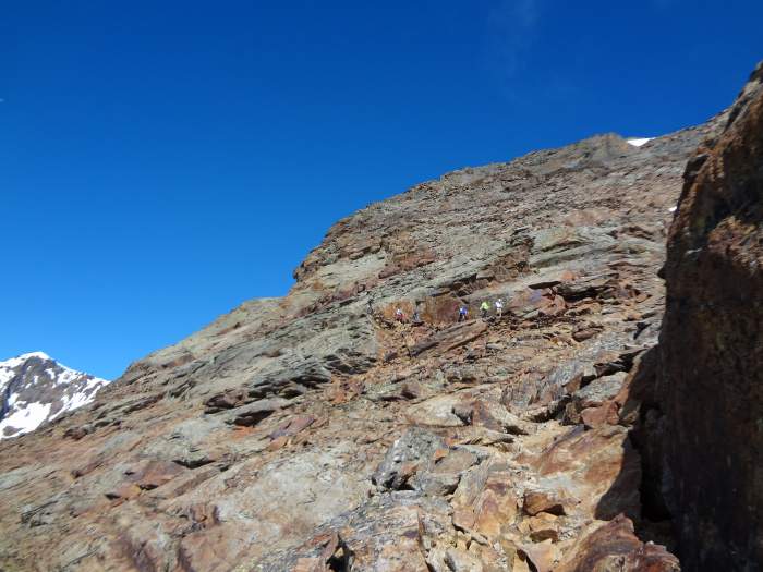
One group of 6, all male and all Italians, were singing in full voice, the picture below shows them coming in my direction as I was going up. This was a song from Toto Cutugno. I commented on their signing and one replied “why not, such a beautiful day and such a great mountain”. Indeed, why not. This is why I love Italy and the Italians, I always feel great there.
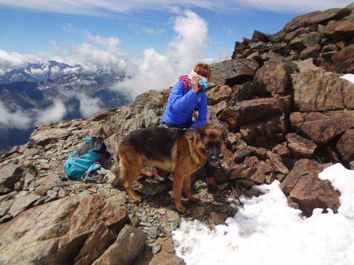
But after descending from the summit, I realized that the area around the hut was crowded. Later, there were many groups going up. Had to stop many times to let them pass. So this is not a place to go if you want to enjoy a mountain in solitude. I met a few with dogs, the picture below shows a beauty, a 2-year old German Shepperd dog:
Timing
The sign at the parking will tell you that you need some 6 hours to the hut. This is very generous I would say. It took me around 5 hours, plus another 20 minutes or so to the summit.
No doubt this can be done faster, I was slow because this was my first climb in the season, and I came from sea level and after a struggle with the virus. Note that the elevation difference is huge, no less than 2045 m (6709 ft).
Final thoughts
In summary, if you plan to climb Monte Vioz in the summertime and if you have great weather, you need no special equipment. I would suggest using some good mid-cut boots, this is good for stability, but as I mentioned above, I have seen domestic people in hiking shoes.
The Refugio Vioz Mantova is one of the highest in the Alps, at an elevation of 3535 meters, and it is so close to the summit. So if the huge elevation difference is too much for you at one go, you can say there overnight and have a rest. There is a cable car as well from Peio Fonti, I normally ignore such things and do not want to collect information about them. But this can help a bit if you have no time or stamina, though it does not go very high. Check the zoomable map above and you will see it.
Monte Vioz is a high mountain, but the normal route from Peio is a simple walk-up, it is doable by anybody in normal physical conditions.
Note that the summit was a front line during WWI, the same holds for all the other peaks around. The picture below is from the Austro-Hungarian cemetery close to the parking, it may be good to visit it after the climb and meditate a bit about what Europe used to be and what it is now.
As you realize, the weather was just perfect, but see my text about Rifugio Cevedale Guido Larcher, a hut in a nearby valley, and you will realize how different it can be on a bad day.
What makes me sad is the fact that I was probably the only foreigner on the mountain that day. People are afraid to travel because of the virus pandemic, and this is for serious reasons. I wonder if the world will ever again be as it was before.
You might want also to read about my tours to Pizzo Tresero and Monte Confinale, which are mountains in the same area. Thank you for reading, there is a comment box below so do not hesitate to ask if you have any questions.
Leave a Reply