If you are on Falzarego Pass and want to get to Lagazuoi hut above it, you have various options. Here I describe the Kaiserjäger ferrata, so keep reading.
Kaiserjäger ferrata (Kaiserjägersteig, Kaiserjäger path) is an easy ferrata tour in an area with incredible history. The route is named after the Austrian soldiers regiment that built it and fought against the Italians on Mt. Lagazuoi during the First World War. You can climb it by starting from either Falzarego Pass or Valparola Pass. Plan up to two hours for the ascent.
Coordinates, numbers and details
- Lagazuoi hut elevation: 2752 m (9029 ft).
- Lagazuoi hut coordinates: 46.5277717 N, 12.0082128 E.
- Route difficulty: easy ferrata.
- Useful map: Tabacco number 03, Cortina d’Ampezzo e Dolomiti Ampezzane. 1:25000.
- Free parking at Falzarego Pass 2105 m (6906 ft), and at Valparola Pass (2168 m; 7113 ft).
- Elevation difference from the Falzarego parking: 647 m (2123 ft).
- Time needed to the summit: 2 hours.
Lagazuoi history, access roads and location
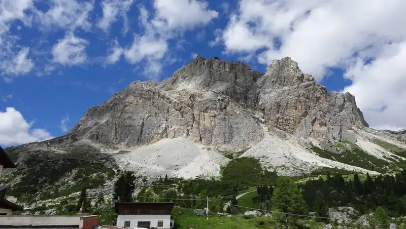
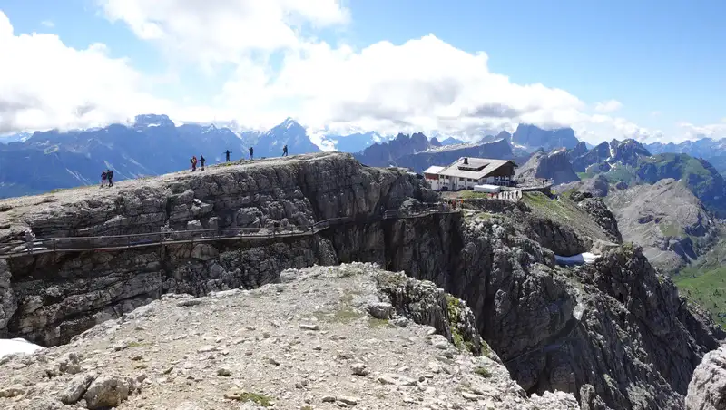
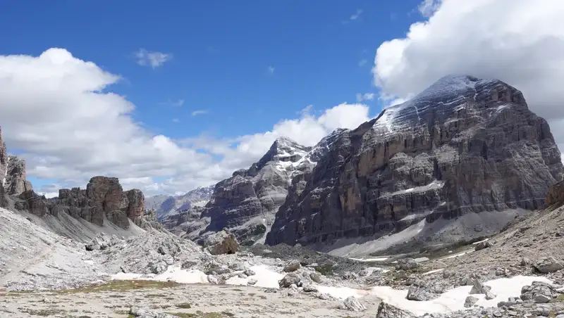
The Mount Lagazuoi area, which you see in the top picture above, is like Swiss cheese, full of tunnels and man made caves. This is part of the Austro Hungarian and Italian defensive lines from WW1, which in some places are separated by only about 50 meters.
The Kaiserjäger path is one of many, and it was built by Austro Hungarian troops as a safe access route from Valparola Pass to the upper trenches and emplacements on the summit of Mt. Lagazuoi.
Nowadays, this area is part of the Italian Alps and the mountain range is called the Dolomites, in Belluno province, but for the Austro Hungarians it was South Tyrol (Südtirol).
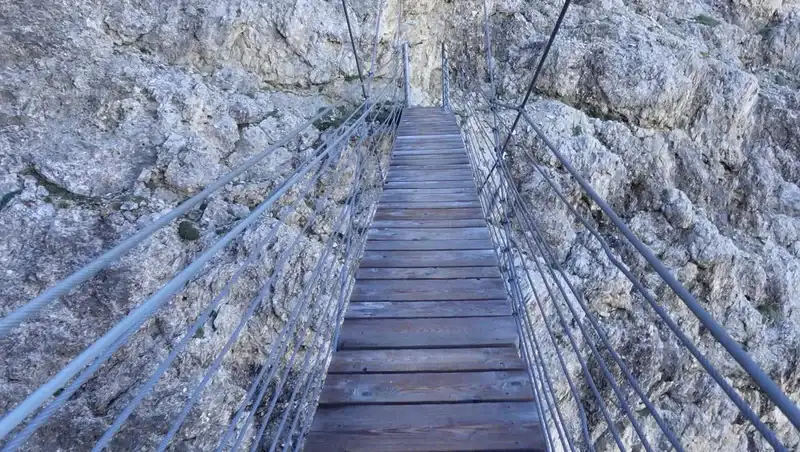
The path was used by soldiers for several years, and it included a long suspension bridge, which is still there or at least its newer version.
The mentioned tunnels were built from both sides: the Italians drilled them into the rock on the south walls of the mountain, and the Austrians from the north and west sides.
There is a whole Lagazuoi site devoted to the history of this amazing place. You can see lots of fortification details in the video:
From what I have seen and experienced during my many visits to the area, this is the most crowded spot in the Dolomites. Three roads converge here, and there are many other attractions in the vicinity.
There is a cable car that can take you to the top in a few minutes, and many visitors use it and then explore the tunnels and descend on foot.
In addition, the popular Alta Via 1 passes through here, and the Lagazuoi hut is one of the places where hikers sleep. In fact, this is the highest point of the Alta Via 1 route.
In the interactive map below you can see all the routes to the summit just zoom in to see the details. The markers 1 and 2 on the map show Falzarego Pass and Valparola Pass, respectively. The marker 3 shows the position of Lagazuoi hut. If you zoom out, you will see all access roads.
But if you are not familiar with the area and are coming by car, the places that should be your destinations are San Cassiano in the north west, Pieve in the south west, and Cortina d’Ampezzo in the east. They lie on the three mentioned roads, and you will see them on the map.
Finding a parking spot
There is plenty of free space to park the car at both Falzarego Pass and Valparola Pass. The former is also the lift station area, and there is a paid parking next to the station.
But this is an incredibly popular place, and if you arrive late in the morning it will be hard to find a spot. Bear this in mind to avoid a long walk along the road if you are forced to park far from either pass.
The road in the direction of Cortina will always be far more crowded because of other attractions, such as Cinque Torri, that draw many visitors.
In principle, far more free parking space is always available around Valparola Pass, and your starting point from there is also at a slightly higher elevation.
Route description
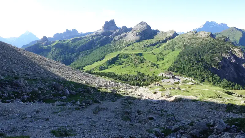
The paths from both passes merge at a point which you will see on the map above. From Falzarego Pass you start behind the lift station and walk first north, then north west under the cliffs above. Below you can see how this part looks.
After that the path makes a loop to the east and then continues north west all the way to the top. The ferrata starts at the suspension bridge which you have to cross this is where I put my climbing harness on.
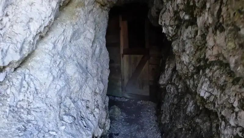
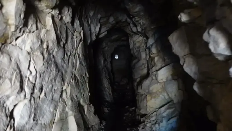
There are just a few sections with cables, and those are easy to navigate you can do this even without ferrata equipment. Below is one spot with a few military caves and cables.
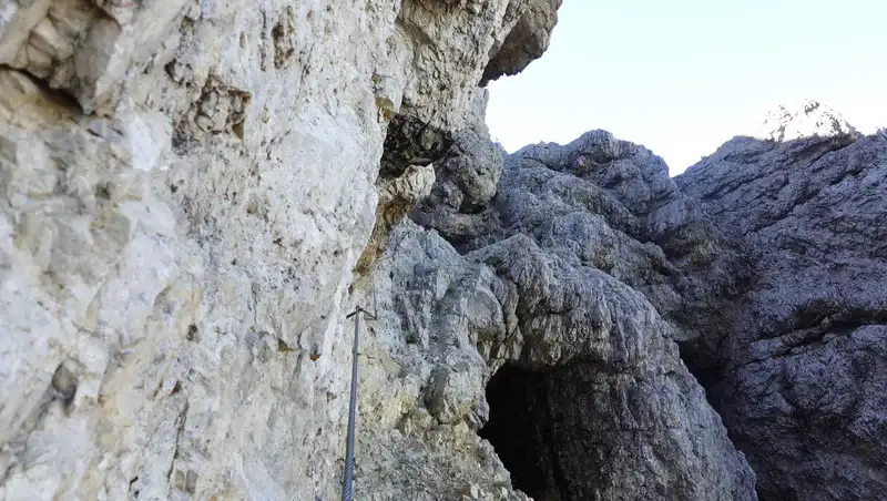
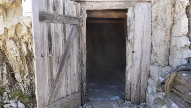
This is the view of the first tunnel built by the Austrians, with military caves inside:
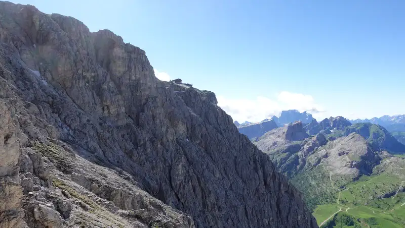
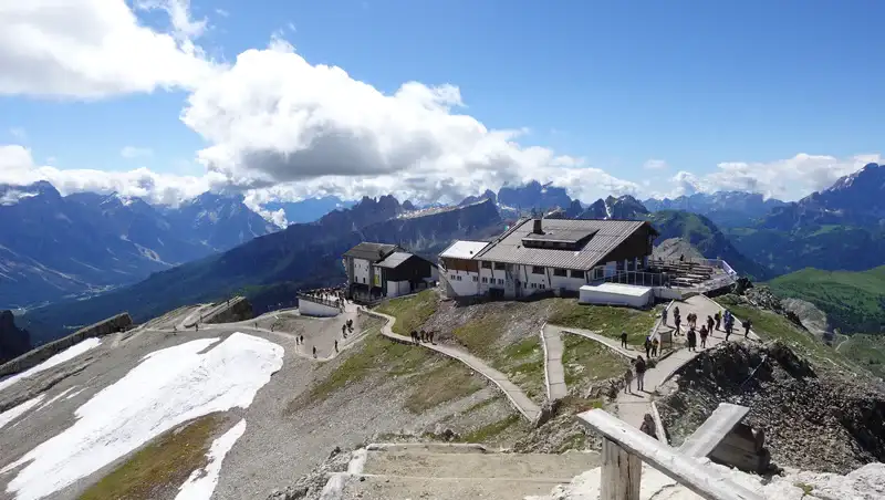
The picture below shows the point far above the ferrata section, and this is the first view of the hut.
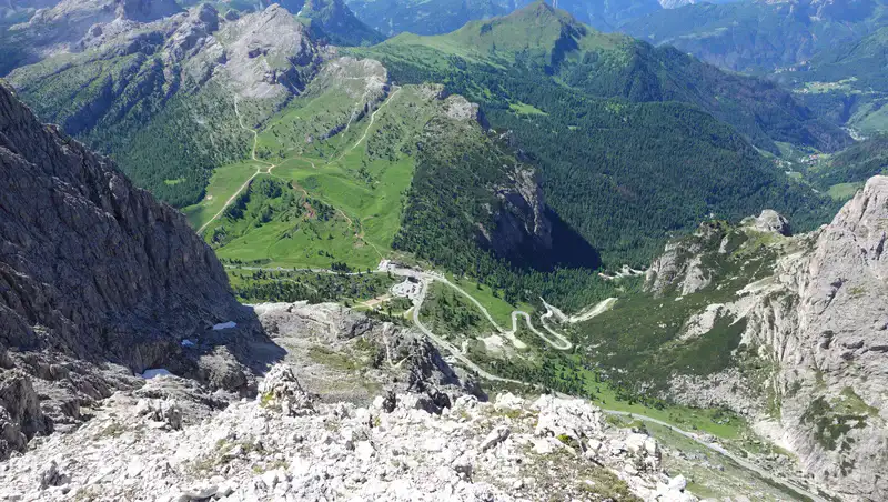
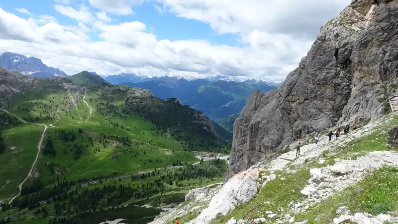
From this part you can still see Falzarego Pass. It is visible in the picture below, together with the road to the Pieve valley on the right. The other road in the bottom right corner goes to the nearby Valparola Pass.
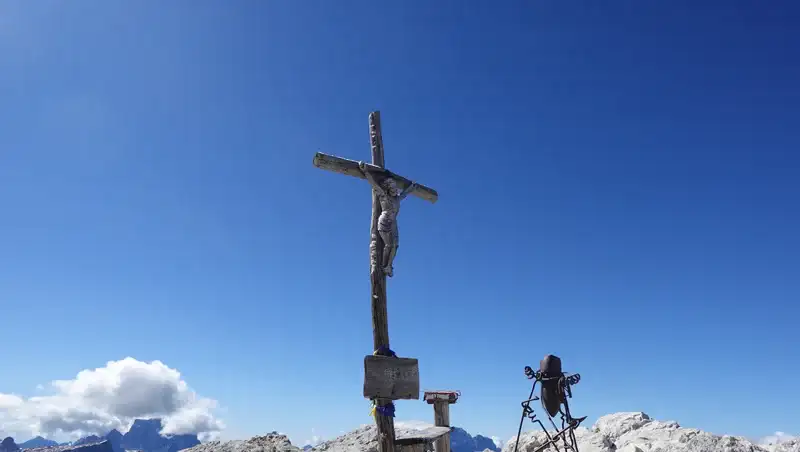
The summit area is very wide and pleasant. There were many people around; when I arrived, the lift was working and visitors were coming from the lift station in huge numbers.
This is a bridge built for tourists, not to be confused with the military bridge on the cliffs below:
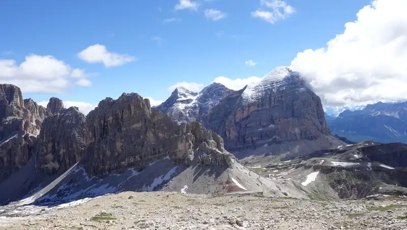
Tofane peaks dominate the views to the east; these mountains look impressive from every possible angle:
The Lagazuoi hut in early morning as visitors are coming from the nearby lift station:
Lagazuoi hut contact details:
- Loc. Lagazuoi.
- I-32043 Cortina d’Ampezzo BL.
- Phone and Fax +39 0436 867303 Mobile +39 340 7195306.
- Email: info@rifugiolagazuoi.com
- https://rifugiolagazuoi.com/
My climb
I started from Falzarego Pass at 7:40 AM, and I was on the summit exactly two hours later. There were several larger groups moving up, both from my side and from Valparola Pass.
The summit and hut area were also crowded; the lift was working. I would say that during the day there were many hundreds of people around, including on my descent route.
Before the climb, I changed my backpack and moved things that I normally always have in its pockets, but I missed taking a torch with me. I realized my big mistake when I wanted to explore some of the numerous tunnels and galleries.
So make sure you do not make such a terrible mistake, or you will miss seeing a lot of what makes this area so popular. This is a true open air museum, and I have seen statements that all the tunnels together are kilometers long.
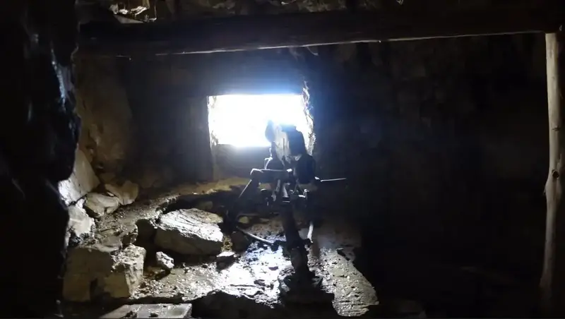
Nevertheless, I entered a few tunnels below the lift station; here are a few pictures from two different tunnels:
I decided to make this a round tour, so I continued towards Forcella Lagazuoi and then to Forcella Travenanzes. The picture below is from the latter.
What you see is Tofana di Rozes, and behind it are the other two peaks, Tofana di Mezzo, and Tofana di Dentro. I have climbed them all, and if you need any information, just let me know in the comment box below.
Below is one more picture from my descent, and you see people going in the direction of the cliffs where there is yet another ferrata that you can use to reach the summit. This is the part of the mountain that was held by the Italians during WW1, so the fortifications and tunnels on this side were built by them.
You can see more about the tour in my video:
My rating of the Kaiserjäger ferrata
This is an easy ferrata, and I use my own grading system based on three essential criteria. The result is as follows:
| Rating Criteria | Rating (A-E; 1-5) |
|---|---|
| Technical difficulty | A |
| Ferrata length | 1 |
| Access route difficulty | A |
| Overall Score | A1A |
So if you are a beginner, this Lagazuoi ferrata would be a great introduction into this activity
Equipment, supplies and accommodation
This was a short day tour, so I used my Osprey Stratos 24 backpack. The boots were Mammut Sapuen GTX, and I also had all the ferrata equipment, which includes a Petzl climbing helmet, a harness, and a Y rope.
None of these ferrata elements is essential I had them because I did not know what to expect. Now you know. But it is better to have them with you.
I also had a pair of Komperdell trekking poles.
Regarding water, directly behind the lift station at the beginning of the tour you have a place to refill. There is no water at Valparola Pass, but there is a hut restaurant there too.
For food, it is up to you you can carry it or have lunch at the summit in the Lagazuoi hut.
The nearest food shops are on the Cassiano side; a small one is in the camping site which you can easily locate on the map above. A much larger food shop is down the road, just a couple of kilometers from the mentioned camping.
As for accommodation, this is the Dolomites, so make sure you book in time.
Final thoughts
In summary, the Lagazuoi Kaiserjäger Ferrata offers a compelling combination of historical significance and natural beauty, making it a standout experience in the Dolomites.
From the WW1 era tunnels and fortifications to the sweeping views of the Tofane peaks, every step of the journey is rich in discovery. The routes manageable difficulty level ensures it is accessible to a wide range of outdoor enthusiasts, whether they are seasoned climbers or history buffs.
However, the popularity of the area, especially near Falzarego and Valparola passes, means early starts are essential to avoid crowds and secure parking.
Whether ascending via the ferrata or taking the cable car for a more leisurely visit, Lagazuoi is an unforgettable destination. The extensive network of trails, tunnels, and facilities like the Lagazuoi hut caters to varied interests and makes this area a true open air museum.
Proper preparation, including carrying sufficient supplies and ferrata gear, will ensure a safe and enjoyable outing. For those who appreciate breathtaking alpine scenery and a deep connection to the past, the Kaiserjäger Ferrata is an experience not to be missed.
Thank you for reading. Let me know if you have questions there is a comment box below. For more texts about mountains in this area, please check under the category Italian Alps.
Please join us at our Facebook group Dolomites Visitors Hub.
Frequently asked questions
Is the Kaiserjäger ferrata suitable for beginners or children
Yes, from a technical point of view it is suitable for beginners because exposure is limited and cables are scarce. However, the environment is still alpine, the elevation is high, and weather changes fast. Children should be used to mountain paths and long ascents, and they should be supervised at all times, especially near tunnels and cliffs.
Do I really need ferrata equipment for this route
Many people walk the Kaiserjäger path without any ferrata gear, especially in dry summer conditions. Still, a helmet makes sense due to loose stones and traffic above. A harness and lanyard add security for less experienced hikers and in early season when snow or ice can remain in shaded sections.
What is the best time of day and season to climb Lagazuoi via the Kaiserjäger path
The best time is early morning, ideally before the cable car starts operating. This reduces crowds and improves safety on narrow sections. The main season runs from late June to early October, depending on snow conditions. Outside this window the route can be icy and dangerous without winter equipment.
Can the Kaiserjäger ferrata be combined with other routes or tours
Yes, it fits well into a round tour via Forcella Lagazuoi and Forcella Travenanzes, or as part of longer hikes in the Tofane and Lagazuoi area. It is also commonly combined with tunnel exploration or a cable car descent, which makes it flexible even if weather conditions deteriorate.
Leave a Reply