All normal climbing routes to Tofana di Mezzo are ferratas, and some are very hard, but Ferrata Lamon is an easy one. I climbed it myself, and it is described here in detail.
Assuming that you do not plan to use the lift, you can reach the summit of Tofana di Mezzo from at least three sides by climbing one of its ferratas.
Ferrata Lamon is the easiest, but it requires reaching the summit of Tofana di Dentro first. This makes it a very long and demanding tour. You are above 3000 meters of elevation for most of the route. However, you will have two summits in a single day, and an incredible WWI bivouac lies on your way up.
Coordinates, numbers & details
- Tofana di Mezzo elevation: 3244 m (10643 ft).
- Tofana di Mezzo coordinates: 46.5509397 N, 12.0654706 E.
- Route difficulty: moderate ferrata.
- Useful map: Tabacco number 03, Cortina d’Ampezzo e Dolomiti Ampezzane, 1:25,000.
- Free parking for this tour: at Pie Tofana (1650 m; 5413 ft).
- Start of the ferrata: the summit of Tofana di Dentro.
- Total time for the ferrata tour: around 80 minutes.
- The lowest point: Forcella Tofana, 3084 m (10118 ft).
- Total time from car parking: 6–7 hours.
[Atahualpa Yupanqui: La Estancia Vieja]
Access roads & location
Tofana di Mezzo is the highest peak in the group of three Tofana peaks that rise above Cortina d’Ampezzo on the west side. This is the only peak in the group with a cable lift system, so many people use it to get directly from the city to the top. As you can imagine, this makes the summit a rather crowded place.
The interactive map below shows all the details you may need. The start of Ferrata Lamon described here is marked as point 1, and the end as point 3. The lowest point on the ferrata (Forcella Tofana) is point 2. Point 4 marks the location of free car parking.
You can zoom in to see more details and zoom out to see all the access roads to the area. If you do not know this part of the Dolomites, it is important to remember that your destination should be Cortina d’Ampezzo.
From Tofana di Dentro to Forcella Tofana
The start of this ferrata is at the summit of Tofana di Dentro. However, you first have to get there, and this is a long walk from the car parking. All the information is available in my separate text about Tofana di Dentro.
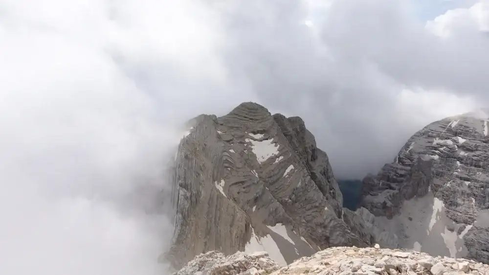
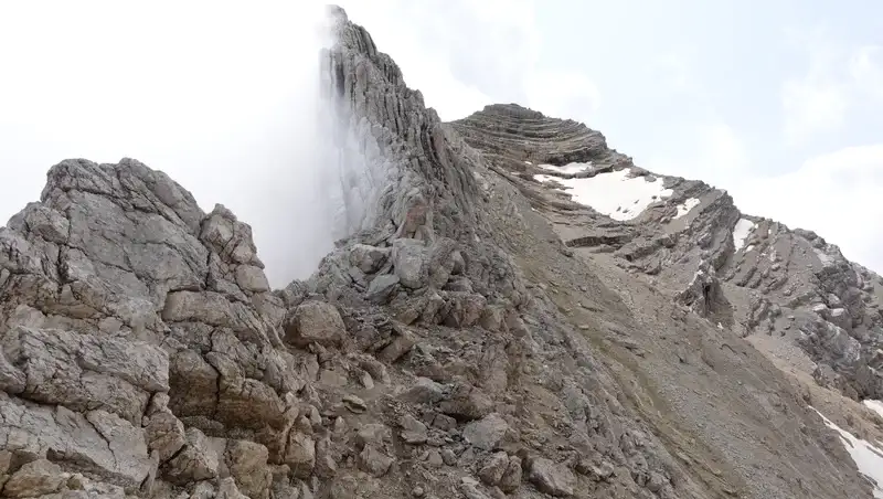
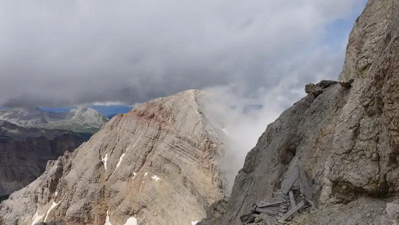
The ferrata starts close to the summit, on its south side. You will see some caves built during WWI, so keep descending from there. From the very beginning, the route is steep; the picture below shows how dramatic it looks when surrounded by clouds.
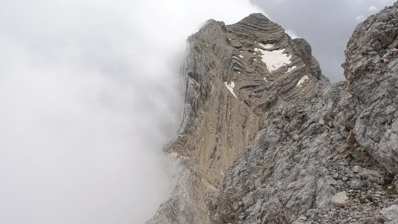
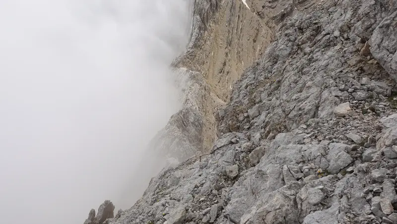
There are a few harder passages, especially as you approach the lower part of the route. The picture below shows one of them.
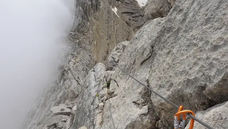
The most exposed sections are located in the lower area around Forcella Tofana. Below you have a view back, but this is not the summit of Tofana di Dentro; it is hidden behind the ridge.
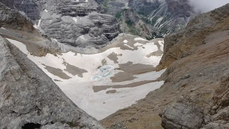
When you reach the lowest part of the route, you will see a lake on your right side, to the west. It is under ice almost all the time; the photo below was taken in the last week of July.
If you look closely, you will see the path above the lake; this is a descent option from both Tofana di Dentro and Tofana di Mezzo.
Following that route, you will arrive at Rifugio Giussani. Bear in mind that there is an extremely steep couloir above the hut, with very unstable gravel and snow often present until August.
From Forcella Tofana to Tofana di Mezzo
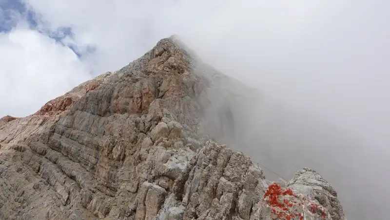
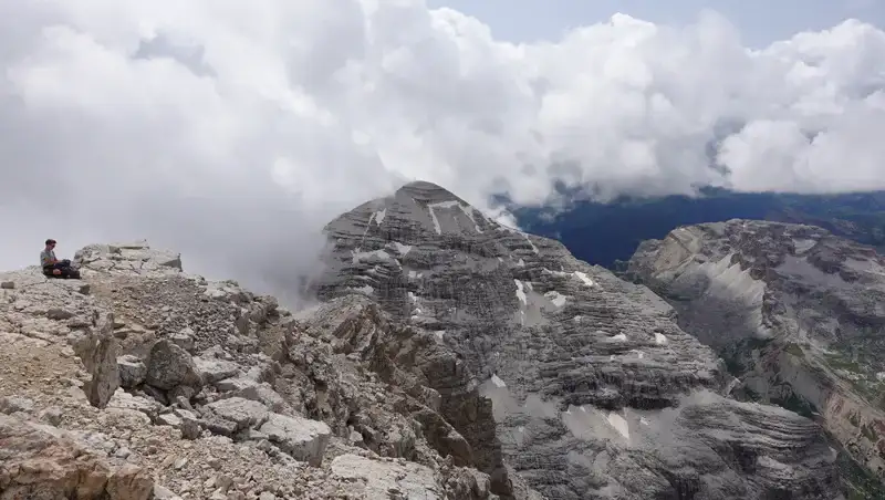
Once you pass Forcella Tofana, you are on an easier part of the route. The picture below shows it all the way up to Tofana di Mezzo.
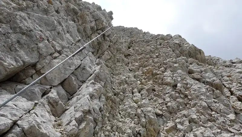
Cables are in place most of the time, and below you can see a typical passage. As a ferrata, this is technically a very easy ascent, but it is at high elevation, which you should keep in mind.
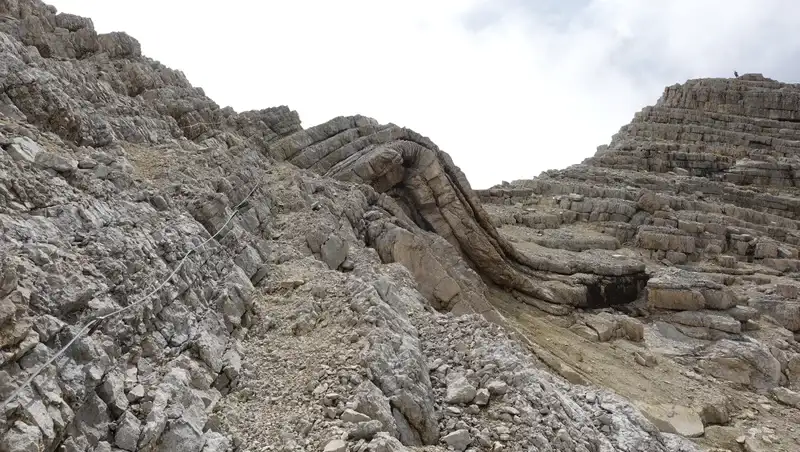
The rock layers are remarkable; I have never seen anything similar. They look like folded blankets, as shown in the picture.
Below is another view back toward Tofana di Dentro. On the right, you can also see remains of WWI trenches and fortifications.
Very soon, your route joins the path coming from the lift station. From there, you are directly below the summit, which you reach in a few minutes. Below is my view of Tofana di Rozes from the summit.
How to descend Tofana di Mezzo
I already mentioned the descent route by the lake toward Rifugio Giussani.
If this is too demanding, you can take the lift down to Ra Vales station and walk the rest of the way to the car. You can also continue to Col Druscie and walk from there to the parking at Pie Tofana.
If you feel strong enough, you can descend via Ferrata Aglio and Ferrata Olivieri, then take another lift down to Pie Tofana. All these options are visible on the map above.
My climb
This was part of a long tour for me. I walked from the parking at Pie Tofana and climbed Tofana di Dentro, then continued to Tofana di Mezzo.
The complete tour took me around 6 hours and 50 minutes, including a long rest at Bivacco Baracca degli Alpini and another on the summit of Tofana di Dentro, where I had a late breakfast. About 1 hour and 20 minutes of this time was spent on Ferrata Lamon.
As you can see from the pictures, the sky was not clear, and views were limited by clouds. However, the weather remained stable, and the clouds made the atmosphere more dramatic.
The first part is described in my previous text, which also includes a video. The Ferrata Lamon section is shown in the following video.
My rating of Ferrata Lamon
Ferrata Lamon has two very different parts, and the total length of cables is approximately 500–600 meters:
The first part, between Tofana di Dentro and Forcella Tofana, is more demanding, but overall it can be described as moderate.
Here you descend about 154 meters of elevation. This may not seem much, but there are exposed passages, as shown in the picture below.
The second part, between Forcella Tofana and the summit of Tofana di Mezzo, is technically very easy, and you almost do not need to clip into the cables.
However, this is an ascent of about 160 meters, which makes it physically demanding. There is a lot of unstable rock and gravel.
Here you can see how I rate the ferrata based on three essential criteria, assuming that you approach it from the lift station. This is the opposite direction of my ascent, but it reflects how most people do the route.
| Rating Criteria | Rating (A–E; 1–5) |
|---|---|
| Technical difficulty | C |
| Ferrata length | 5 |
| Access route difficulty | A |
| Overall Score | C5A |
Bear in mind that this is a high-elevation and very long route, and the weather can change several times during the climb. Do not attempt it without proper weather protection in your backpack.
Equipment, supplies & accommodation
For this tour, I used my Mammut Lithium 40 backpack. My boots were Mammut Sapuen GTX, and I carried full ferrata equipment, including a climbing helmet, harness, and Y-rope.
There is no water on the route, so you must carry enough with you. The last place to refill is at Pie Tofana parking. You must also carry your food, although you may plan a meal at the lift station after the tour.
As this is the Dolomites, make accommodation reservations well in advance.
Note that there are four campsites close to Cortina d’Ampezzo, one on the north side and three on the south side. I have stayed at them many times; they offer all basic facilities.
Final thoughts
Climbing Tofana di Mezzo via Ferrata Lamon is a long and demanding high-altitude tour that rewards good preparation and endurance.
The route combines steep, exposed sections with easier terrain and offers impressive geological formations, historical remnants, and wide alpine views.
While technically moderate, the length, elevation, and lack of water sources require careful planning and appropriate equipment.
For climbers with some ferrata experience, Ferrata Lamon is a memorable and varied route through one of the most striking parts of the Dolomites.
Thank you for reading, and feel free to ask questions in the comment box below. For more texts about mountains in this area, please check the category Italian Alps. In particular, see my article about what happens if you fall on a ferrata tour.
Please join our Facebook group Dolomites Visitors Hub.
Frequently Asked Questions
Is Ferrata Lamon suitable for beginners to via ferratas?
Ferrata Lamon is often described as one of the easier ferratas in the Tofana group, but it is not ideal as a first ferrata. While the technical difficulty is moderate, the route is very long, exposed in places, and located entirely above 3000 meters. Beginners should first gain experience on shorter ferratas at lower elevations before attempting this route.
What is the best time of year to climb Ferrata Lamon?
The optimal period is mid-July to early September. Earlier in the season, snow and ice can remain on ledges and in couloirs, increasing objective risk. Late summer generally offers more stable conditions, though sudden weather changes are always possible at this altitude.
Do I need a via ferrata set even though the route is easy?
Yes. Despite its relatively low technical grade, a complete via ferrata set (helmet, harness, and energy-absorbing lanyard) is recommended. The route includes exposed traverses, loose rock, and steep sections where a slip could have serious consequences, especially given the elevation.
How physically demanding is Ferrata Lamon compared to other Dolomite ferratas?
Ferrata Lamon is physically demanding rather than technically difficult. The sustained altitude, cumulative elevation gain, and length of the tour make it comparable in effort to harder ferratas at lower elevations. Good endurance, efficient pacing, and proper acclimatization are important factors for a successful ascent.
Leave a Reply