There are various options to climb Sasso delle Dieci, here you have my own first-hand description of the route from Rudiferia in Val Badia. Keep reading.
Sasso delle Dieci (Sass dales Diesc, Zehnerspitze) can be climbed either from Val Badia or from Fanes National Park area.
From Val Badia you have several different options. One is to get to Santa Croce Hospiz and then follow the ferrata route up to the Fanes plateau. Yet another option is to start from a free parking at Rüdeferia (Rudiferia) and to walk all the way up in the east direction to Forcella de Medesc (2533 m), and then continue to the summit which will be in the north direction.
If you climb from the Fanes area, your initial destination should be Lavarella and Fanes huts which you can approach from multiple sides. From the huts, you continue in the west direction and at some point your route will join the mentioned Rudiferia route.
Coordinates, numbers & details
- Sasso delle Dieci coordinates: 46.62256° N; 11.96065° E.
- Elevation: 3026 m (9928 ft).
- Route difficulty: walk up & short easy summit ferrata.
- Useful map: Tabacco number 07, Alta Badia Arabba-Marmolada, 1:25000.
- Free parking at Rüdeferia 1660 m (5446 ft).
- Time needed to the summit: around 4 hours and 45 minutes.
Access roads & location
There are many variants of the routes mentioned above. You can see them if you zoom into the map given below. To see access roads to this part of the Dolomites, please zoom out.
Note also that you can climb Piz La Varella from the same place. If you zoom into the map above, the route will be obvious, focus on the Forcella de Medesc area.
Route description
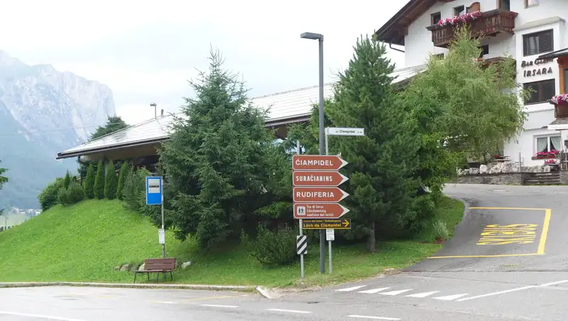
To get to Rüdeferia (Rudiferia), you will follow the sign on the main road in San Cassiano area, see the picture below. This you will see if you drive from Falzarego pass direction:
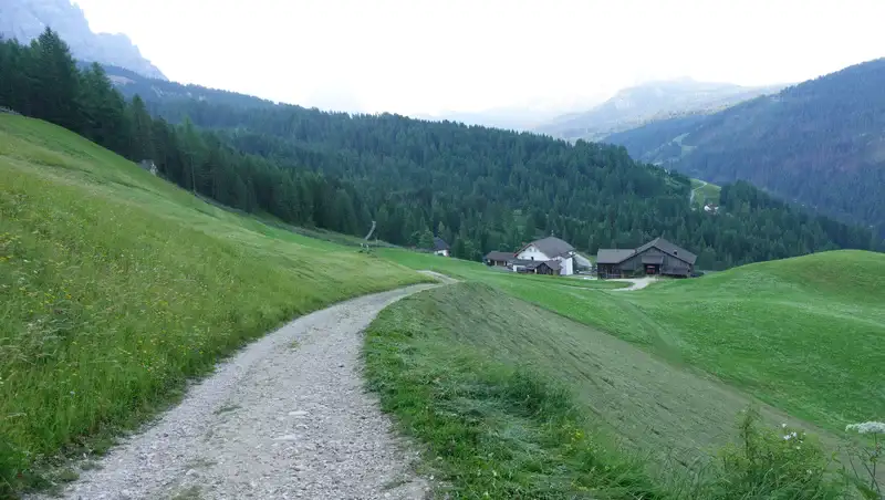
From here, keep driving up and this will take you to the end of the road with a small parking. The parking is free, but this is a small area with a space for two to three cars maximum.
From there you follow the signs in the direction of Forcella de Medesc (2533 m), the route 12 in the map. Here are a few photos from that initial part of the route:
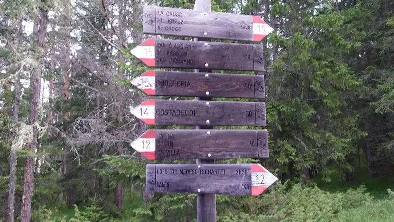
The lower part of the route goes through a pleasant forest. Observe that from here you can get also to the mentioned Santa Croce Hospiz and then follow the ferrata route, see the picture below. This is the route 12A in the map.
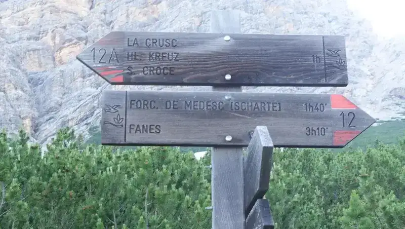
But if you continue in the direction of Forcella de Medesc, very soon you will be above the tree line and the pass will be above you as in the picture:
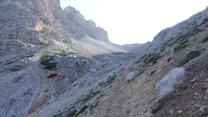
It took me a bit more than two hours from the parking to the pass. There are no exposed passages anywhere in this part.
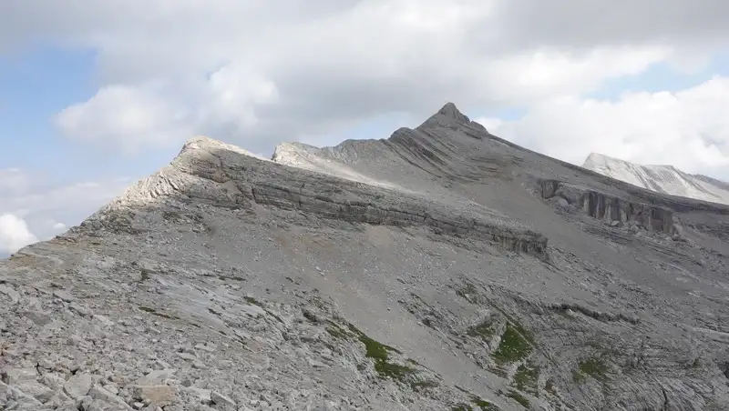
When you get there, you will have excellent views of the Fanes plateau. Very soon you will see the summit as well, it is in the middle of the picture below. Far on the right is Cima delle Nove which I also climbed and described here in the site.
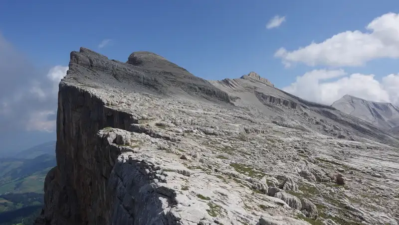
The cliffs on the left are vertical and now you realize why they look so impressive when you admire them from Val Badia far below. You can certainly approach cliffs, but the route is mostly at a safe distance from them. On the map, this is the route 12B and 7B.
In this area you will see the previously mentioned route from Lavarella and Fanes huts coming in your direction.
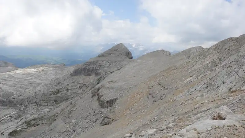
Do not miss to climb Le Ciaval (Sasso Cavallo, 2907 m), it is visible in the picture above. You will not need more than half an hour extra time for that. You can see it also below when it was already behind me as I was approaching Sasso delle Dieci.
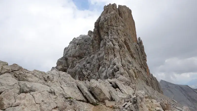
Till now, there are no exposed passages at all. However, directly under the summit of Sasso delle Dieci you might want to use your ferrata equipment if you have it with you.
There are a few exposed section here and the summit cliffs are steep, but if you do not have equipment, you can manage without it. I had it all in the backpack, but I was lazy to take it out and use. Below you can see how it all looks, but do not underestimate these cliffs.
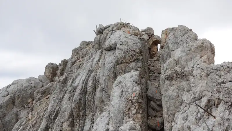
Cables are in place and they are in a good state, and you always have them at hand at exposed places. You can see some details here:
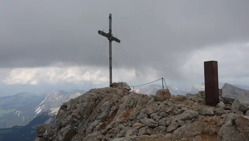
The impressive summit cross is among the largest I have ever seen, and it is made of wood:
Summit ferrata rating
My rating is based on three essential criteria:
| Rating Criteria | Rating (A-E; 1-5) |
|---|---|
| Technical difficulty | B |
| Ferrata length | 1 |
| Access route difficulty | E |
| Overall Score | B1E |
The ferrata is very short, but to get to the cables you have a long walk from the car parking, hence my rating E for the access.
My climb
I started from the parking at 7 AM. Luckily, it was completely empty, and it was so even when I returned from the tour.
The weather was perfect in the morning, with a completely clear sky, but during the day it changed and you can realize this from the pictures. The part through the forest was particularly pleasant, and there was nobody around.
After two hours, I was at the Fanes plateau and continued walking. I knew that part from my previous unsuccessful attempt when I had to give up because of the weather.
Only when I was already under the last 50 meters of the summit ferrata, I realized there were a few people behind me. They came from the Santa Croce Hospiz ferrata route.
I arrived to the summit at 11:45 AM, and this makes it 4 hours and 45 minutes in total. Very soon three people arrived, but they did not stay long, so I decided to stay as long as possible and enjoy the moment.
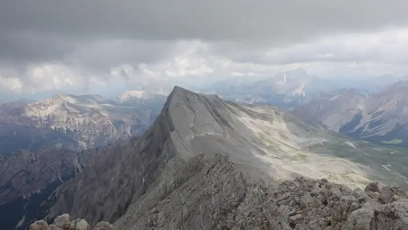
When you are there, the most impressive thing to watch is Cima delle Nove, and the picture below shows why this is so. I do not remember any other mountain in the Alps with such smooth slabs. That mountain is definitely harder to climb than Sasso delle Dieci.
On my way back it was lightly raining in some short intervals. I was thinking of descending by making a round tour and by following ferrata, but with the rain this did not look like a great idea.
As a result, I went back the same way. The picture below is my last view back towards the summit:
When I was in the forest it was raining quite a lot, but I had all what was needed for the rain so I was fine.
You can see more about the tour in my video:
Equipment, supplies & accommodation
For this tour I used my Mammut Lithium 40 backpack, so just follow the link to read my full review. The boots were Mammut Sapuen GTX, and they were perfect.
I mentioned rain, so as usual, I had a full rain protection set, and this includes a poncho, rain pants, and a rain jacket. I also had a pair of trekking poles, plus ferrata equipment in the backpack, but I did not use it.
There are a few food shops for supplies in the valley, you will find them easily.
As for accommodation, there is a camp in the area, just a few kilometers from the car parking and close to the main road.
Final thoughts
In summary, if you want to climb Sasso delle Dieci from Val Badia the way described here, you do not need any special equipment.
This holds also if you approach the mountain from the Fanes area because these two routes merge at the Fanes plateau. I have walked this route too, so let me know if you have questions.
But if you have problems with vertigo, bring ferrata stuff, you will need it only in the last 50 meters below the summit cross.
By following the route described here you will avoid paying for parking in the valley and for the lift from there, and you will enjoy climbing the mountain in a more purist way.
Please join us at our Facebook group Dolomites Visitors Hub.
Leave a Reply