• Home
  • ABOUT
  • HOW TO START
  • ALPS
    • Austrian Alps
    • German Alps
    • Italian Alps
    • Slovenian Alps
    • Swiss Alps
    • Huts and Shelters
    • Roads and Passes
  • TENERIFE TOURS
  • ABOUT EQUIPMENT
  • FAQs
  • WRITE FOR US

Mountains For Everybody

Site about mountaineering, climbing and equipment, for those who love mountains

  • Outdoor Sleeping
    • Tents
      • Solo tents
      • Tents for 2 People
      • Tents for 3 People
      • Tents for 4 People
      • Tents in general
    • Tarps and Shelters
    • Sleeping Bags
    • Sleeping Pads
  • Backpacks
    • Day Packs
    • Mid-Size Packs
    • Large Packs
    • Kids & Youth
    • Packs FAQs
  • Clothing
    • Men’s
    • Women’s
  • Footwear
    • Men’s
    • Women’s
    • Insulated
  • Gear
    • Camp stuff
    • Lamps
    • Poles
    • Filters
  • Newsletter subscribe

Climbing Fluela Schwarzhorn in Swiss Alps

Last Modified: 01/13/2025

I planned climbing Fluela Schwarzhorn from the moment I saw it first from the Fluela Pass several years ago, and I finally did it recently. This is my report about the tour, so keep reading.

Fluela Schwarzhorn as seen from my earlier tour to Fluela Wisshorn. The Fluela Pass is below.

Where is it

Fluela (Flüela) Schwarzhorn is a very sharp peak which rises directly above the Fluela Pass (2383 m; 7818 ft) on its south side, in the Davos area of Swiss Alps. The map below shows you its location and the access roads.

Coordinates

  • Longitude: 46° 44′ 6″ N (46.735).
  • Latitude: 9° 56′ 30″ E (9.941667).
  • Elevation: 3146 m (10322 ft).

Access roads

The only access road is the one that goes over the Fluela Pass, and in driving there the Pass should be your destination. So you can get there either from Davos in the north-west direction, or from Susch in the east.

The parking at the road on the east side of Fluela Pass.

Note that the start point for the route is some 600 meters from the pass, on the east side. There is a parking on the side of the mountain, it is shown in the picture.

The road is good and very attractive from both sides, worth passing even if you do not plan any climbing around. It is closed in the winter time.

The Fluela Pass seen from the summit.

Accommodation

There is a Hospiz directly on the pass; this is not a hut, and yes they have showers with hot water, and no they will not let you use it even with paying unless you are staying there for the night. Otherwise, continue in any of the two directions, and you will find a place to stay either in Davos or in the villages on the east side of the pass.
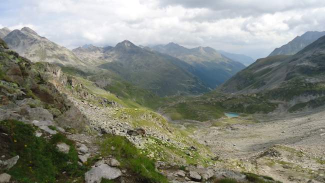

The route

The route goes around the mountain, so you will approach the summit from the south side. All the time this is a simple walk up, no exposed sections at any point. The path is visible all the time and markings are around, so orientation is never an issue.

View from the lower part of the route, the summit in the distance.

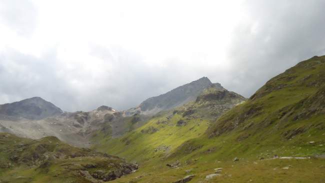
This is an easy summit in the true sense and this is mainly due to such a high car access. But the height difference is still around 750 meters, so do not underestimate it, and the route is longer than you may expect when you see the peak from the pass; see the map above.

The pass is closed in winter, therefore, it is advisable to plan climbing when you have the car access. I have seen the mountain in the winter time and it looked inaccessible.

In the middle of the route and view back.

Equipment & water

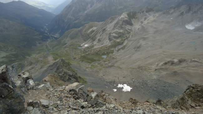
If you carry a water filter or purifier, no need to carry any water. You will be passing several streams, and there are some small tarns below the path on the lower part of the route. I was carrying my Pure2Go purifier & filter. The upper part, roughly above 2700 m, is without any water so refill the bottle in time.

You do not need any special equipment for this tour, just the usual stuff for a day tour on high altitudes. It was free from snow when I was there in August. But see my text about clothing in the summer in the Alps. Here is my summary:

  Recommended   Essential
  • Waterproof hiking boots.
  • A day pack.
  • Trekking poles.
  • Sunglasses.
  • Sun protection hat.
  • Crampons in the case of snow or ice.
  • NA

My tour

I was driving from Vent in Otzal Alps in Austria (see here what I was doing there) and I came to the pass quite late. A storm is expected afternoon and I knew I did not have much time, so climbing Fluela Schwarzhorn looked like a good idea for the day.

I knew the area well from my previous visits and passes, I climbed the Fluela Wisshorn which is on the other side of the road.

As mentioned above, the start of the route is not on the pass, it is below, on the south side, there is a sign so you cannot miss it.

I started the tour at 10:50 and I was on the summit at 12:50, so in two hours exactly. No doubt it would take me longer if the weather was good, I would simply enjoy the climb and go slow. But the storm was coming and I wanted to get to the summit in time.

There was nobody around until the place where I met the old man and his grandchild, you can see them in the picture. I asked for permission to make this photo. He told me there was yet another hour to the summit. He was right, but I did it faster because of the storm that was coming.

The best moment - a Swiss man with his grandchild, I met them at around 2800 m.
The best moment – a Swiss man with his grandchild, I met them at around 2800 m.

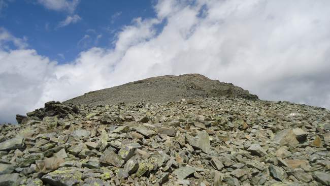
The upper part is a bit steeper in one section only, but this is a walk up all the time. It was very windy; rain and hail started as soon as I arrived at the summit. So I did not stay longer than 5 minutes, the place is very exposed and there is always a danger of lightning.

On the way back the weather improved but it was obviously still raining on the summit. I met several groups of people going up. Many of them were totally unprepared, in light walking sneakers, without warm clothes. I find this irresponsible regardless how easy the climb can look.

View back towards the Schur valley.
The final part below the summit is surprisingly mild for a peak that looks so sharp.

So, all in all, my climbing of Fluela Schwarzhorn was a nice and pleasant tour. Later, I spent a sleepless night in the car on the pass. It was raining all the time, with ice and snow sometimes, and with an incredibly strong wind. But in the morning it was calm, so I continued in the direction of Livigno and Bormio, and climbed Cima Solda after that.

Thank you for reading. It will be great to hear from you, there is a comment box below. So let me know if you know the area and if you could write something and publish here in the site, I have an open invitation for guest authors. Have a nice day. 

Spread the love

Mountains for Everybody site is reader-supported. This means that some of the links in the text are affiliate links, and when you buy products through our links we may earn some small commission to keep running the site. Filed Under: Swiss Alps Tagged With: Fluela pass, Schwarzhorn

Comments

  1. Pj says

    09/15/2017 at

    Wow! I feel like I took a little trip with you! That is very cool! I love that you are conscious about being prepared and have a well-laid plan for us if we would want to make the same trip to these Alps, as well! Thank you Jovo!?

    Reply
    • Jovo says

      09/15/2017 at

      Thank you Pj, great to hear that you like my story. This is a nice easy day tour when you are short in time for something more demanding. All the best.

Leave a Reply Cancel reply

Your email address will not be published. Required fields are marked *


My photo on the summit of Jalovec.Hi everybody and welcome to my site which I nurture with love and passion. Here I describe my own climbs and give reviews of equipment. I hope you will enjoy it. More about the site and about me here.

Categories


Cookies Statement

In this site we do not have any cookie tool. But we do use services by third parties that either use cookies or may be doing so, yet we do not have any control of it. This is covered in their privacy policies. For more details please check in our Privacy Policy page.


  • Contact
  • Privacy Policy
  • Affiliate Disclosure

My Most Memorable Tours

  • Magic Moments On Mount Teide Tenerife
  • Climbing Weissmies solo
  • Climbing Mount Fuji
  • Climbing Zugspitze solo
  • Lagginhorn my first 4000er

Recent Posts

Are Canvas Backpacks Good for Hiking featured picture.

Are Canvas Backpacks Good for Hiking?

Why Is There a Gap Between My Back and Backpack featured picture.

Why Is There a Gap Between My Back and Backpack?

Huts and Bivouacs in Dolomiti di Brenta Alps: Interactive Map featured picture.

24 Huts and Bivouacs in Dolomiti di Brenta Alps: Interactive Map

What Is the Easiest Way to Deflate a Self-Inflating Mattress featured picture.

What Is the Easiest Way to Deflate a Self-Inflating Mattress?

What Is the Most Uncomfortable Thing About Backpacks featured picture.

What Is the Most Uncomfortable Thing About Backpacks?

Affiliate Disclosure

I am a participant in the Amazon Services LLC Associates Program, an affiliate advertising program designed to provide a means for sites to earn advertising fees by advertising and linking to amazon.com. So when you buy something from this website, I may receive an affiliate commission. These are my opinions and are not representative of the companies that create these products. My reviews are based on my personal experience and research. I never recommend poor quality products, or create false reviews to make sales. It is my intention to explain products so you can make an informed decisions on which ones suit your needs best.

Categories

  • About mountains in general (33)
  • Alps (138)
    • Austrian Alps (5)
    • German Alps (3)
    • Great mountain roads and passes (10)
    • Huts and Shelters (27)
    • Italian Alps (84)
    • Slovenian Alps (25)
    • Swiss Alps (21)
  • Backpacks (248)
    • About Packs in General (76)
    • Day Packs (63)
    • Large Packs (79)
    • Mid-Size Packs (52)
    • Packs for Kids & Youth (2)
  • Clothing (22)
    • Men's Clothing (11)
    • Women's Clothing (8)
  • Equipment (61)
    • Camp stuff (37)
    • General Stuff (3)
    • Headlamps (8)
    • Trekking poles (3)
    • Water filters & purifiers (9)
  • FAQs (123)
  • Footwear (22)
    • Insulated Footwear (4)
    • Men's Footwear (17)
    • Women's Footwear (6)
  • Guest Author posts (5)
  • Hiking tours (22)
  • Sleeping Bags (109)
  • Sleeping Pads (90)
  • Tenerife (24)
  • Tents and shelters (256)
    • About tents in general (22)
    • Solo tents (23)
    • Tarps and Shelters (12)
    • Tents for 2 People (69)
    • Tents for 3 People (57)
    • Tents for 4 People (91)
    • Winter tents (25)

Copyright © 2025 · Mountains for Everybody · All Rights Reserved