The breathtaking Dolomiti di Brenta Alps are a dramatic limestone massif in Trentino, Italy, celebrated for its jagged peaks, sheer cliffs, and pristine alpine meadows. Here you have an interactive and zoomable map with all bivouacs and huts presented.
The map is your ultimate guide to exploring this UNESCO World Heritage site. Designed for hikers, mountaineers, and nature enthusiasts, it pinpoints the network of all mountain huts (rifugi) and bivouacs in the area, that serve as vital bases for unforgettable adventures.
If you are not familiar with the area, from this video you will realize why it is worth going there, have a look:
About the name: Why “Dolomiti di Brenta”?
Though physically separated from the main Dolomites range by the Adige Valley, the Dolomiti di Brenta are geologically and culturally linked to their eastern and much larger counterparts.
Like the broader Dolomites, these mountains are formed of dolomite rock. This is a magnesium-rich limestone that gives the peaks their pale, luminous hue and distinctive ruggedness.
This geological kinship, forged millions of years ago in ancient coral reefs, earns them the “Dolomiti” name despite their western isolation. In fact, the first western neighbors of these peaks, namely Adamello and Presanella, are made of a completely different type of rock.
The Brenta group’s unique position also shapes its character, blending Mediterranean influences with alpine severity, creating a haven for diverse flora and fauna.
Geology and mountaineering
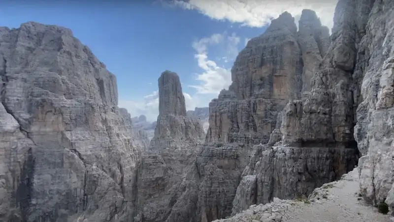
The Dolomiti di Brenta’s towering spires and karst formations are a geologist’s dream, sculpted by erosion and tectonic forces into a playground for mountaineers. The range is renowned for its via ferrata routes, such as the Via delle Bocchette, which weave through dizzying ledges and offer panoramic vistas.
Classic peaks like Cima Tosa and Crozzon di Brenta beckon climbers, while multi-day treks link huts for immersive tours.
Whether you are scaling exposed ridges or hiking serene valleys, the Brenta’s terrain demands respect and rewards with unparalleled beauty.
This interactive map below equips you to navigate trails, locate shelters, and uncover the stories of this extraordinary range.
Zoom in to see details of the trails, and zoom out to get an idea about access roads and geography. It will help you to explore the Dolomiti di Brenta and let its wild majesty inspire your next adventure.

Unlock the Full Premium Interactive Maps of Huts & Bivouacs in Brenta Dolomites
The overview and list above are free. Get instant lifetime access to two premium interactive maps: main version plus topo version with better contours and geography.
- 24 huts and bivouacs with precise markers (blue for regular huts, red for bivouacs)
- Clickable pins with details, coordinates, and links
- Main interactive map + bonus topo map for improved terrain view
- Fully zoomable, searchable, with terrain/satellite options, mobile-friendly
- Regular updates
- One-time payment – no subscriptions
- Coverage of the entire Dolomiti di Brenta group
Instant access after payment • Supports independent Brenta Dolomites content
Bivouacs are marked with red markers, and regular huts with blue markers. I hope I have collected them all, but if you realize that some are missing, do let me know in the comment section below, and I shall add them in the map.
When you hover above any of them, you will see the coordinates. But if you click, you will be linked to various sources with detailed information about them.
To help you even more, I have added below the Topo version of the map to better see the geography and contours:

Instant access after payment • Supports independent Brenta Dolomites content
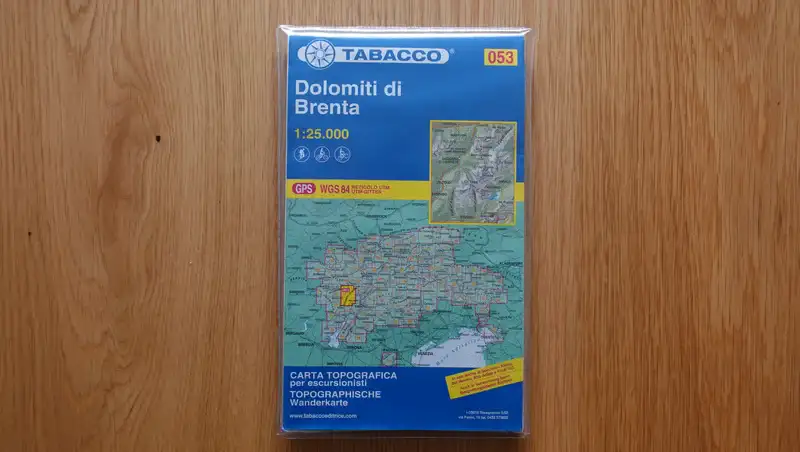
When you are there, you will need also a paper map, I have ordered recently one for me (the picture below), the Tabacco 053, Dolomiti di Brenta available at Amazon US and Amazon DE.
How about malgas?
If you zoom into the map above, you will notice numerous malgas that are not included into my markings. But they may be of great importance if you hike in the area.
The term “malga” refers to a traditional alpine pasture or dairy farm typically found in the mountainous regions of northern Italy, including the Dolomiti di Brenta Alps.
Derived from the Italian word for a mountain hut or shelter, a malga is a seasonal structure. It is used by shepherds and farmers during the summer months when livestock, such as cows or sheep, are brought to graze on high-altitude pastures.
These buildings often serve as both living quarters and small-scale dairies, where cheese and other dairy products are produced using traditional methods.
Unlike mountain huts (rifugi) or bivouacs, which primarily cater to hikers and climbers with lodging and meals, malgas are agricultural in purpose, focused on pastoral activities.
Some malgas, however, have evolved to offer hospitality, selling homemade cheeses, butter, or even simple meals to visitors, blending their rustic charm with tourism. In many of them you can even sleep.
In the context of the map, excluding malgas makes sense because my focus is on huts and bivouacs designed for mountaineering and hiking, as malgas serve a distinct function tied to alpine farming rather than trail-based exploration.
But bear them in mind, there are many of them on lower elevations. They add a cultural and gastronomic dimension, showcasing the region’s pastoral heritage.
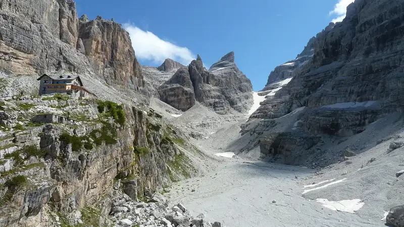
From the photo above you realize what kind of environment you have here. The area is famous for its extremely attractive ferratas so make sure you have appropriate ferrata equipment. This includes a harness, Y-lanyard, and a helmet.
There are complete ferata sets to buy all these elements together, you will find this on Amazon DE. Amazon US, and Mammut.
Adamello Brenta Natural Park
Note that this area is a part of what is known as the Adamello Brenta Natural Park. If you follow the link you can read more about it.
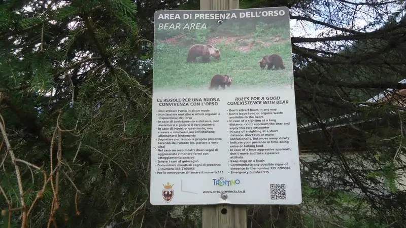
But here to stress that Brenta Alps area is a home for many brown bears. In fact, brown bear is the symbol of the national park. This just to know if you plan overnight tours from low valleys, you would not want to have a close encounter.
There is yet another map here in the site, with Adamello and Presanella bivouacs and huts, you might need it if you are visiting the area. But we have also a separate complete map with all bivouacs in the Italian Alps.
You might want to know that I have a book Dolomites Solo with my first-hand mountaineering reports, have a look:

Thank you for reading. Please join us at our Facebook group Dolomites Visitors Hub.
Leave a Reply