There are several routes to Lago Coldai, here I describe the access from the point which is on the main road one kilometer below Passo Staulanza. Keep reading.
At elevation of 2143 m above sea level, with a relatively easy access from the surrounding valleys, and with a pleasant mountain hut nearby, Lago Coldai is a very popular place.
If you visit it from the main road in Val di Zoldo, there are no exposed passages, and you do not need any special equipment to get to this beautiful alpine lake.
Coordinates, numbers & details
- Lago Coldai elevation: 2143 m (7031 ft).
- Lago Coldai coordinates: 46.3988231 N, 12.0625483 E.
- Route difficulty: walk up.
- Mountain group: Civetta, Dolomites.
- Useful map: Tabacco number 015, Marmolada – Pelmo Civetta, 1:25000, and Tabacco number 025, Dolomiti di Zoldo Cadorine e Agordine, 1:25000.
- Free parking elevation: 1700 m (5577 ft).
- Highest point on the route: Forcella Coldai 2191 m (7188 ft).
- Time needed to hike to the lake: 2 hours.
About Lago Coldai, access roads & location
Lago Coldai is a stunning alpine lake nestled in the Dolomites of Italy, specifically within the Civetta group. This gem of a lake sits at an altitude of approximately 2143 meters, offering breathtaking views of the surrounding jagged peaks, particularly the imposing wall of Monte Civetta.
The lake, known for its vivid blue waters and serene environment, is a popular destination for hikers and nature enthusiasts looking to immerse themselves in the natural beauty of the Dolomites.
The hike to Lago Coldai is accessible via several routes. One of the most common starting points is from Palafavera, where visitors can either take a chairlift part of the way or walk the entirety. This trail to the lake is generally considered of moderate difficulty, making it suitable for those with a reasonable level of fitness.
Along the path, hikers might encounter herds of sheep and a variety of alpine flora, enhancing the experience with the sights and sounds of mountain life. The lake itself, framed by the dramatic landscape, provides a perfect spot for a picnic or simply to enjoy the tranquility away from more crowded tourist spots.
The interactive map below shows all the details of the area. If you zoom out you will see the access roads, and if you zoom in you will se various routes to the lake. The markers are explained in the text below.
Route description
The route described here starts around one kilometer below Passo Staulanza. So from the pass you continue in the direction of Palafavera and park at a sharp turn that is impossible to miss. This is marker 1 in the map above. You will see water available at this place, so this is a chance to fill your bottles.
From this place there is a gravel road in the west direction, and some people drive for another kilometer or so and park by the road.
You keep walking in the direction of casera Vescova (1722 m) which is shown in the picture below, this is the marker 2 on the map.
The picture was taken when I passed the casera and was high above it. Can you guess the name of the mountain on the right? The area with the start point on the man road is visible in the distance.
From the casera follow the route 561 to rifugio Coldai. Very soon you will be on a high and pleasant plateau which is shown below. This is view back to it from a point below Coldai hut. There are lift lines from various sides to this area, but I think that some of them operate in winter only.
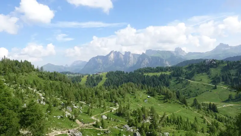
The part below the hut is the steepest, and the path zigzags through the area which is now above tree line so it can be hot on a sunny day. Monte Pelmo is in sight all the time, the picture below shows its view when you are below the hut.
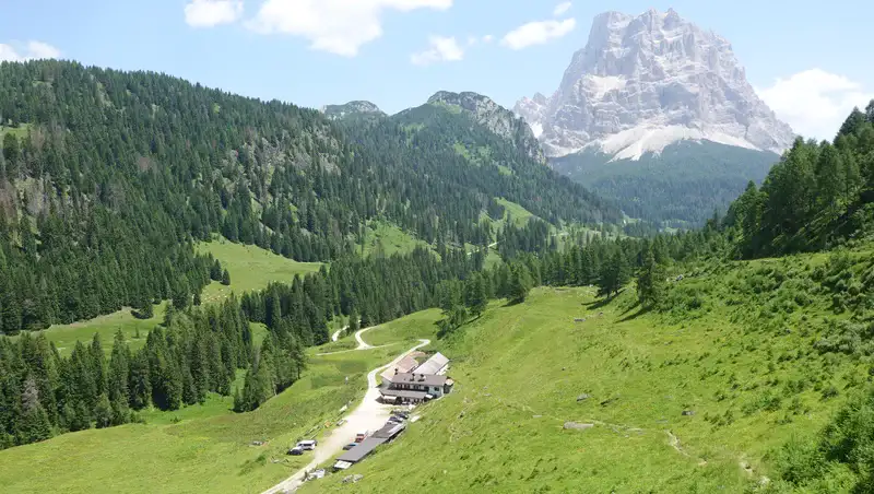
Eventually, you get to the hut (the marker 3 in the map above) and it will appear in front of you as the photo below shows.
Rifugio Coldai
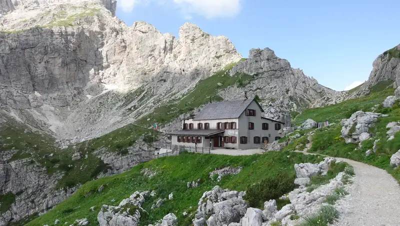
The official name of the hut is Rifugio Adolfo Sonino al Coldai, it belongs to the CAI Section of Venice, and there are 93 beds, toilets with hot water, lighting with generator and photovoltaic system. The hut is open during the summer season, from mid-June to the end of September.
The hut was built in 1905, and in 1931, with the financial contribution of the Sonino family, it was expanded. It was named in memory of Adolfo Sonino, a mountaineer who died in 1930 at Punta Fiames.
The hut was set on fire in the autumn of 1944 during a Nazi raid on some partisan units that were in the area. It was rebuilt and reopened in 1948.
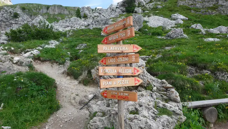
Rifugio Coldai is at an elevation of 2135 m above sea level. This is a busy place with several routes from the valleys around converging here, see the sign with routes below. It is also on Alta Via 1 route, so it may be hard to find a place to sleep here.
Rifugio Codau contact details:
- Coldai Locality
I-32012 Val di Zoldo – BL – Dolomites. - Telephone +39 0437 789160.
- https://rifugiocoldai.com/
From the hut to the Coldai lake
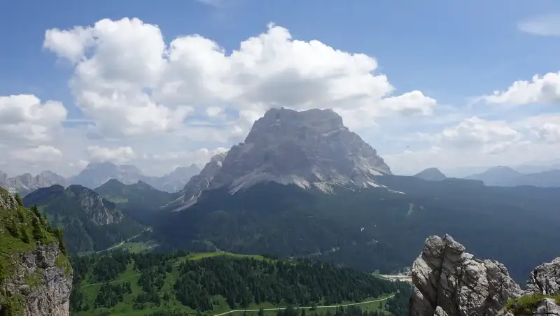
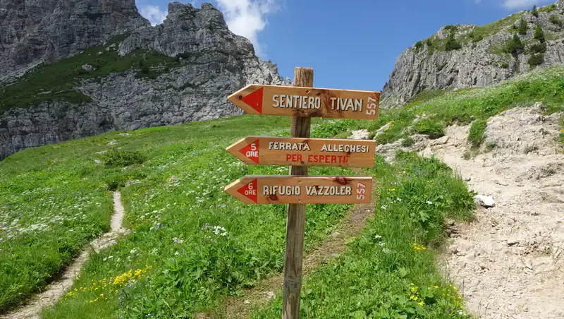
From the hut you keep going up towards Forcella Coldai (2191 m) which is the highest spot on the route. But before getting there you will see the signs shown below, this is the direction to ferrata routes in the Civetta group.
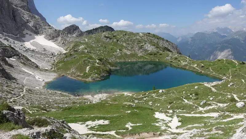
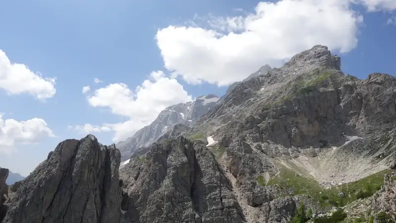
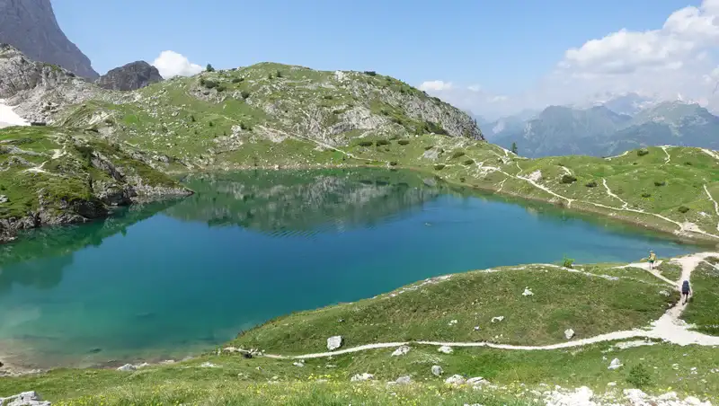
Monte Civetta is on your right side, see the picture, and from the Forcella Coldai you descend to the lake.
The lake water is crystal clear, the picture shows its true color under sunlight. It is cold yet full of tiny fish that is just a few centimeters in length. I took a long rest on the right side in the picture and the curious fish was coming to me all the time.
I was puzzled with the presence of fish in such a high alpine lake, and this was not the first time that I see it in such places.
Earlier, I have seen a video where it was mentioned that fish gets pooped out from ducks. When they eat fish eggs elsewhere, from a thousand eggs statistically two may survive. Now, if a duck comes to such a lake and poops, there will be eggs in the water, hence the fish.
I do not remember seeing any sign against bathing and swimming, but I have read somewhere that it is not allowed.
However, one couple from America who were on their Alta Via 1 tour, have jumped in the water to wash out their sweat, without thinking too much about respect for environment. I knew they were from the US because, on my walk up, they were in a group not far from me, and the man was very loud.
Please see more in my video:
Equipment, supplies & accommodation
Lago Coldai is at a higher elevation than Lago Sorapis and Lago Federa, just to know if you are familiar with these other lakes in the Dolomites. But here again this is just a simple walk up and without any exposed passage.
For me, this was a short day tour so I used my Osprey Stratos 24 backpack. Regarding footwear, you can use whatever you have, I had my Nortiv 8 boots. I also had a pair of Komperdell trekking poles.
Regarding water, as mentioned, you have it at the main road, and there is also the casera plus the hut on your way up. You can carry your food or have meals at the mentioned two places.
As for accommodation, this is about the Dolomites, so make sure you make a reservation in time. Note that there is a large camping place in Palafavera below in Zoldo valley, and one smaller also in Pecol, check the map to see more.
Final thoughts
In summary, if you plan hiking to Lago Coldai, you can do the tour up and down before lunchtime. But in my view this would be pity. It is better to enjoy the place and spend the day on high elevation as long as you can.
The area around the lake is with grass so you can stay there and enjoy the day. You can even climb the nearby Cima Coldai (2403 m) which is directly above the hut and the lake on the north side, I have seen a few people on the summit.
Thank you for reading and let me know if you have questions, there is a comment box below. For more texts about mountains in this area please check under the category Italian Alps. In particular, read my text about Lago Sorapis and Lago Federa.
Please join us at our Facebook group Dolomites Visitors Hub. Subscribe to my weakly newsletter and stay informed, the subscription form is given below.
Leave a Reply