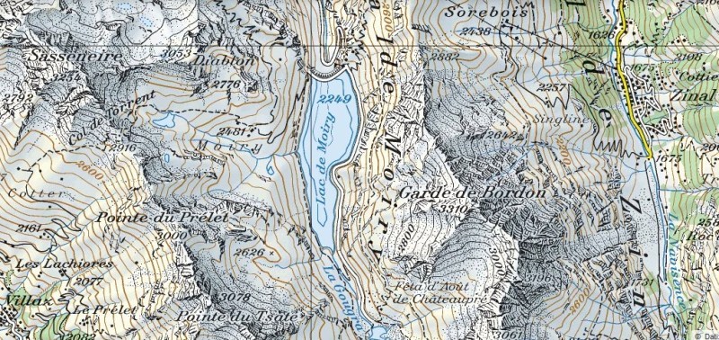
By height, Garde de Bordon (3310 m) is not so prominent compared with other mountains in the area. However, it covers a larger area than any of the nearby mountains. Garde de Bordon splits Val d’ Anniverse into two parts. On maps, you will find it between village Zinal and the Moiry lake, in Wallis province of Switzerland. In this page, you have the description of the route to the summit from the Moiry lake side.
[Vivaldi: Cum dederit (Nisi Dominus)]
The coordinates of the mountains are:
- Latitude 46.120782
- Longitude 7.597307.


Access road
The only access road is from the Rhone valley in the north. You take the road from Sierre, along Val d’ Anniverse in the direction of Zinal and Grimentz. If you choose Grimentz, you will pass the village and continue toward Moiry lake. The road is good regardless which direction you take.
Routes
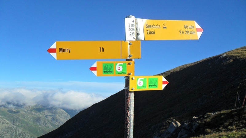
From both valleys, you will follow the signs to Corne de Sorebois and Col de Sorebois (2835 m). If you are not purist, from the Zinal side you may use a lift up to 2438 m. From the Moiry lake dam (2249 m), walk to Col de Sorebois. The lake dam can be reached by car or by a post bus from Grimentz. This is the same access as in the case of Sasseneire and Pigne de la Le described within this site, and also at Peakware.
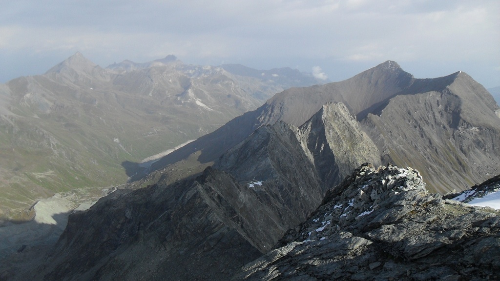
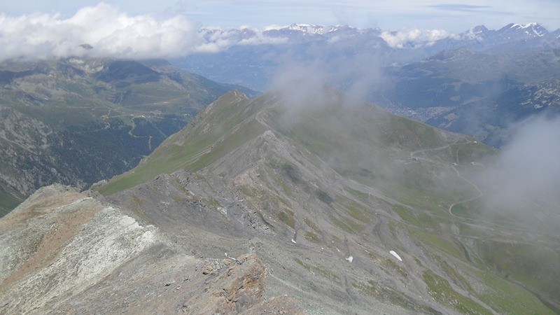
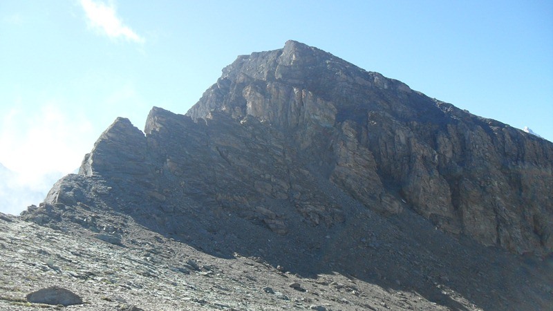
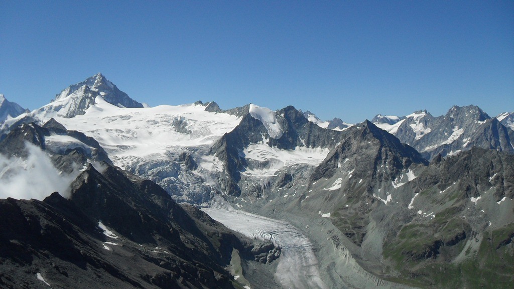
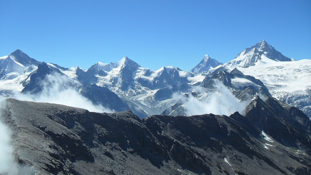
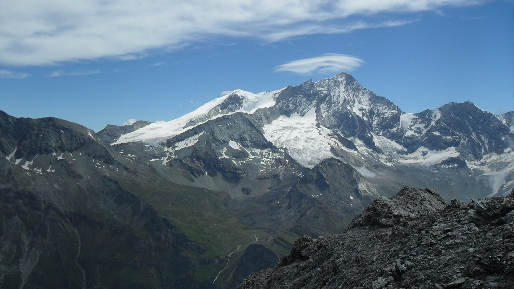
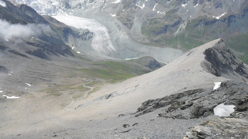
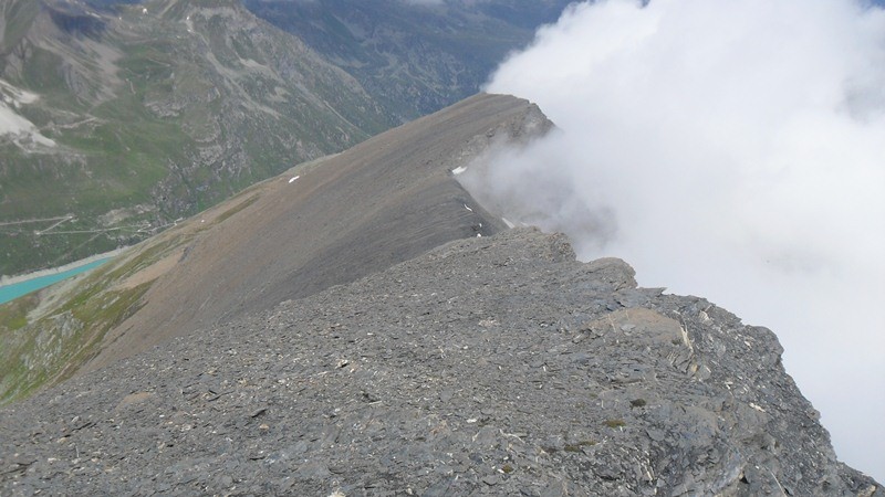
From Col de Sorebois the route follows the long ridge for at least 2.5 km in the south direction. You are almost all the time above 3000 meters so you can imagine views on every side. Photos given below will show you how it all looks like. On the right are Becs de Bosson (3149 m), Tsevalire (Tsavolire, 3026 m), Sasseneire (3254 m) etc. Far in front of you are Pigne de la Le, Dent Blanche (4357 m), Zinalrothorn (4221 m) and even further Matterhorn (4478 m). On the left, you will see Bishorn (4153 m), Weisshorn (4506 m), and many others. The list is far from complete.
The route is marked only by cairns, but it is visible and obvious. Only one place may be difficult, it is at 2/3 of the route from the Col to the summit. This is a steep stone wall with a couloir which you enter from the lake side of the ridge. The rock is unstable and the area is steep. It continues with a cliff where a rope of about 6-8 meters is fixed, and you will have to climb along the rope.
After this section, the rest is a very simple walk to the summit. From the summit, it is possible to descend along the southwest ridge to Comba Rossa and further toward the glacier lake and the car parking. This is the starting place for the route to Pigne de la Le.
About equipment
| Recommended | Essential |
|
|
My climb
I climbed Garde de Bordon in 2012. I was camping below Moiry hut and in the morning went by car to the car parking at the Moiry dam. From there I followed the route towards Sorrebois pass. This was a pleasant walk over meadows.
After arriving at the the pass (2835 m), I continued the long ridge walk which is in the south direction. At the rocky couloir with the fixed rope, by mistake I left my walking poles. My original plan was to traverse the mountain, but due to that mistake, later I had to descend the same way.
I was at the summit for more than one hour, enjoying breathtaking views and perfect weather conditions. The photos above depict these memorable moments. From the car parking to the summit it took me 3 hours and 40 minutes. Only two other people were on the mountain that day, they arrived at the summit when I was about to leave, therefore only pure nature on my photos here.
No particular equipment is needed for this mountain. For the accommodation please visit my separate post.
I shall be happy to answer any question regarding this mountain, so please use the comment area below.
Darren says
This looks like a truly amazing part of the world, and I’m so glad you are sharing it all on your website. Is this where you live? Somewhere near this region?
I can imagine Bear Grylls out there with his crew filming one of those survival shows. You could spend your entire life exploring those mountains and still not see everything. Thanks for another great post.
Jovo says
Hi Darren, no I do not live there. I am based 1000 kilometers away in Belgium, the lowest part of Europe, and presently on Tenerife island. Many thanks.
Dylan says
This is a really amazing website. You obviously care a lot about mountain climbing and it shows,it how well your site looks and how much information you have.
Garde de Bordon looks really a,axing and if,I ever find my self in the Swiss also I’m going to have to get over there.
How long have you been climbing for?
Thanks for reading my comment
Jovo says
Hi Dylan, thank you. Garde de Bordon is a huge massive and great for mountaineering. There are some other nice peaks around like Sasseneire, Pigne de la Le, Becs de Bosson which I climbed. I have been climbing in the past 30 years or so.
Kaveh says
Hello,
That was a good description and good good pictures as well and completed with that google map, I really liked that. Just one thing that I was not able to find was that if any amateur can follow that way or have to follow some professional mountain climber?
really interesting post, thank you for that.
Regards,
Kaveh
Jovo says
Hi Kaveh, thank you. Great to see your comment. As for your question, you will not need any guide or professional climber. You can do it on your own. Though having somebody with you is surely always better.
Shawn says
Hi!
LOL< I love your statement, "After this section, the rest is very simple walk to the summit" I have never had a simple walk on top of a mountain, lol. Love your article and your story! I bet the other route would still be awesome, even without the thrills. You caught the beauty in your pictures, very well done :) If I ever get over there this will be on my agenda! Shawn>>
Jovo says
Hi Shawn, great to read your comment. If you ever manage to get there you will realize, after you pass the obstacle described in the text it is indeed just a walk on a very high terrain, with a very gentle slope toward the summit.
TheDopestMatrix says
oh ok, Switzserland! I was trying to figure out where this mountain was. What a beautiful looking climb! Funny story, I have a friend in Switserland right now visiting, maybe I can inspire him to check out this place by him visiting your website 😉
Thanks for sharing, definitely want to go there one day
Matt TheDopestMatrix
Jovo says
Point taken, many thanks, I have now added a Google map of the mountain so it is easy to locate it geographically.
JellyB says
Hi Jovo
I am a keen mountain climber and hill walker and found your website awesome! I’ve never done the alps and its my dream to trek the alps one day. Brilliant photos and I just enjoyed reading your information. I love the geographical stats you’ve included. Well done! Keep me informed as I will use your information for my future trekking endeavors!
Cheers!
Jelly.
Jovo says
Hi Jelly, great to read your comment. Thank you for kind word. I wish you to experience Alps someday. Best luck.