Recently, I climbed Antelao solo after sleeping in a tent on the mountain, and here you have my first-hand report about the tour, so keep reading.
There is only one normal route to the summit of Antelao, and the most convenient way to get to it is to start from the car parking above San Vito di Cadore. But elevation difference is 2124 m (6969 ft), so splitting the tour in two parts by sleeping in one of the huts, or taking a tent for an overnight stay, are the best options.
Antelao coordinates, numbers & details
- Elevation: 3264 m (10709 ft).
- Nearest city: San Vito di Cadore, Cortina d’Ampezzo.
- Mountain group: Dolomites, Italian Alps.
- Coordinates: 46.4517944 N, 12.2619078 E.
- Route difficulty: walk-up and scramble passages with many very exposed passages.
- Elevation difference from the car parking: 2124 m (6969 ft).
- Parking coordinates: 46.4623783 N, 12.2162672 E.
- Hardcopy map for the tour: Dolomiti di Auronzo e del Comelico, Tabacco 017, 1:25000.
- Huts on the route: Rifugio Scotter, Rifugio Galassi.
Note that the Alta Via 3, Alta Via 4, and Alta Via 5 routes go very close to the north side of the mountain, so if you are on any of them, this can be a detour to add to your adventure.
The interactive map below is with markers that show the following:
- Marker 1 – car parking.
- Marker 2 – Rifugio Scotter.
- Marker 3 – Rifugio Galassi.
- Marker 4 – my camp position.
- Marker 5 – Laste area.
- Marker 6 – Antelao summit.
Please zoom out to see access roads and cities around. You will realize that there is access to the marker 4 from the east side as well.
Antelao climbing route description
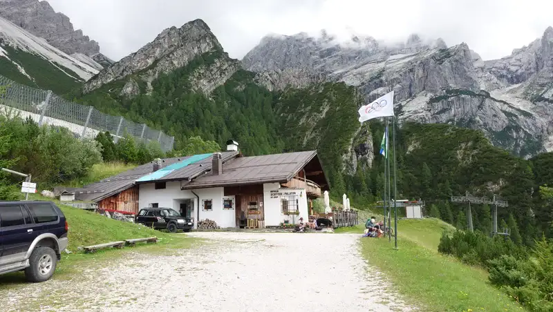
The car parking above San Vito di Cadore village is very large and free. From there, the first part of the route is a gravel road (closed for public) that goes through a forest. Very soon you will arrive at Rifugio Scotter, the photo below, which is at an elevation of 1570 m (5151 ft).
As you realize, this is still very low, so if you plan to sleep and to continue next day, it is better to continue to Rifugio Galassi which is at around 2030 m (6660 ft) of elevation. The path between the two huts zig-zags over a scree area, and it is quite hard.
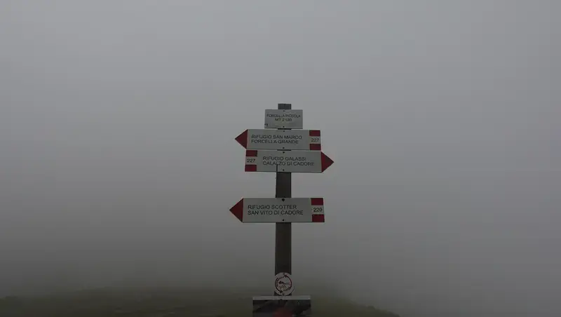
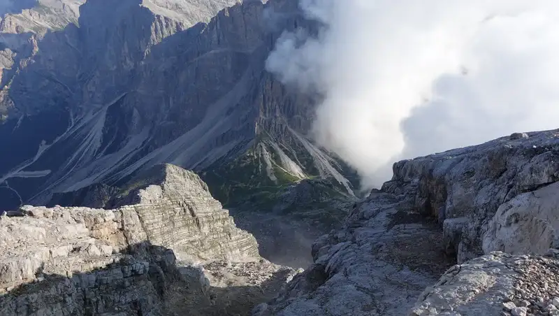
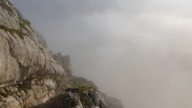
Note that you do not have to go to Galassi hut, the route to Antelao splits to the right when you are at Forcella Piccola (2120 m, 6955 ft). It is visible in the map above, but see also the photo with some info that is available there. This place is accessible from the east as well, from the village Calalzo di Cadore.
Observe the clouds, for my climb it looked hopeless to go farther. From that point, you walk up in the south direction, first over a pleasant grassy area until you get to a plateau at around 2200 meters of elevation.
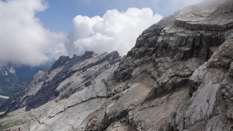
After that the route follows numerous ledges with pure rock, and this remains so all the way to the summit. From the very beginning of that rocky part there are many exposed passages, and it is necessary to be very careful.
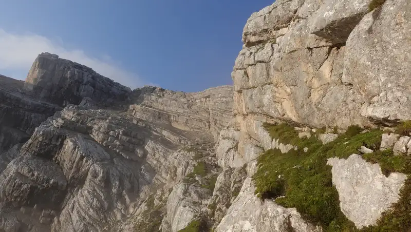
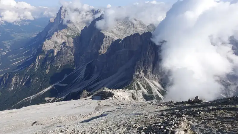
The photo below shows my view back towards Forcella Piccola pass when I was already high on the mountain. Rifugio Galassi is somewhere on the right close to the cloud in the photo. On the left is the ridge where the route to Antelao goes. The mountains on the opposite side belong to Sorapis group.
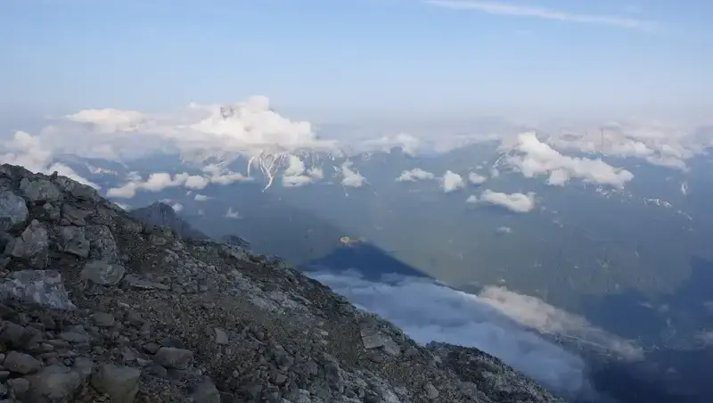
This is a high mountain, and it is quite separated from the rest, so prominence is exceptional and the same holds for views. Below you get a bit of it, with the view of Monte Pelmo in the clouds, and the Antelao shadow far below.
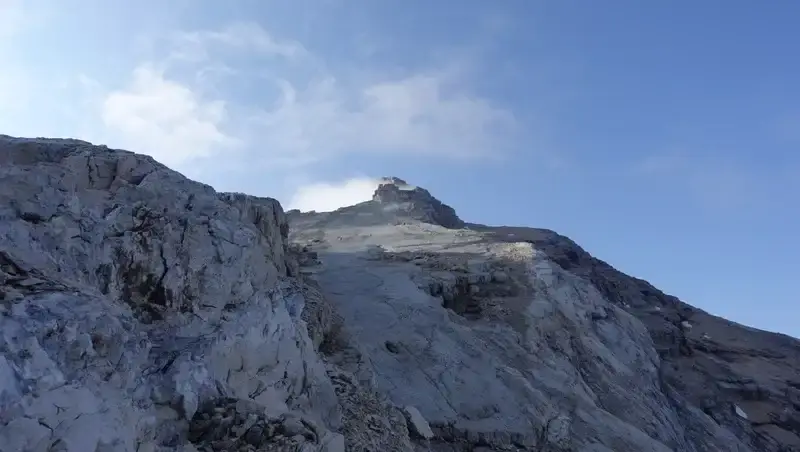
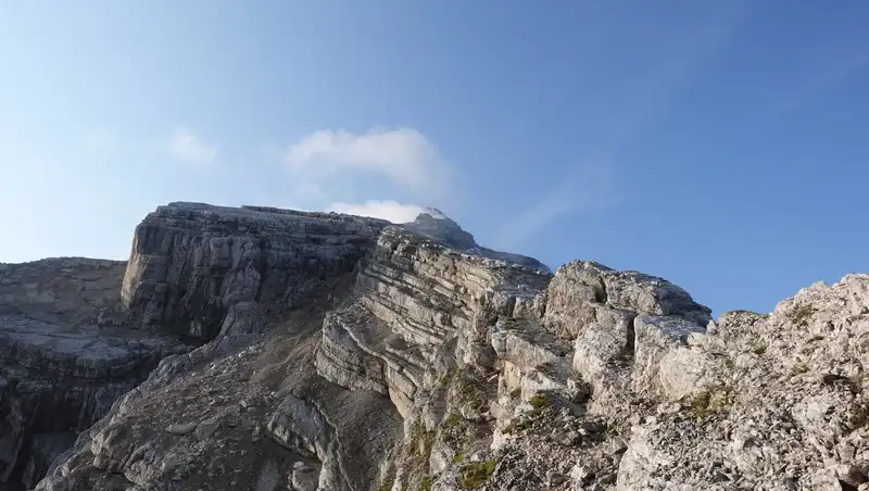
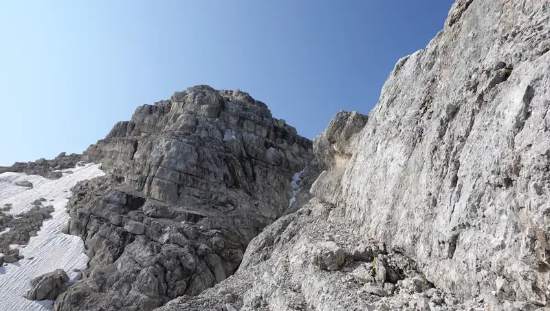
When you first see the summit, as in the photo below, then bear in mind that the hardest part is still to come. The summit is far behind, only slightly visible.
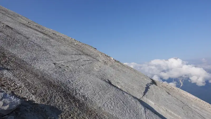
The ridge in the middle of the climb ends up with what is known as Laste, a smooth and beautiful area, but with a huge drop underneath it, and this is what makes it scary. It looks like made of concrete. Going up here is far easier than descending, bear this in mind:
After Laste comes the hardest part below the summit. It includes walking on narrow and occasionally very exposed ledges, sometimes with scree, so this is where you have to measure every step. There is a huge half a kilometer drop on the left (north side), with a small glacier on the bottom of it.
I did not really take great photos of the drop and exposure to show all this, and this is simply because I was too scared and concerned for my safety. When you are at such places alone, you feel vulnerable and weak.
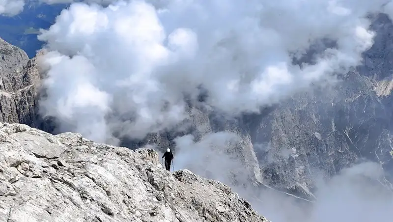
The photo below shows the summit, and the route goes below it, completely from the right to the left, following the natural ledges.
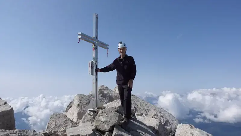
The summit is with a cross, you can see it in one of the photos below. Here are two photos of me, both taken by Daniele Fontana who passed me below the summit and was watching me approaching him.
On the way back you follow the same route. Make sure you memorize it when you go up, it may be a bit tricky to find and follow it on descent.
My Antelao tour
I decided to split the tour in two nearly equal parts, and even then this was a hard tour. So I took my outdoor sleeping equipment with me and stayed on the mountain during the night.
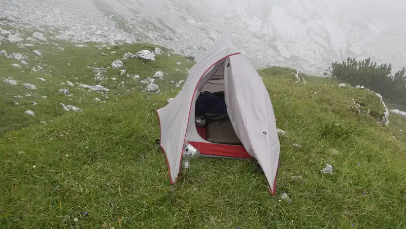
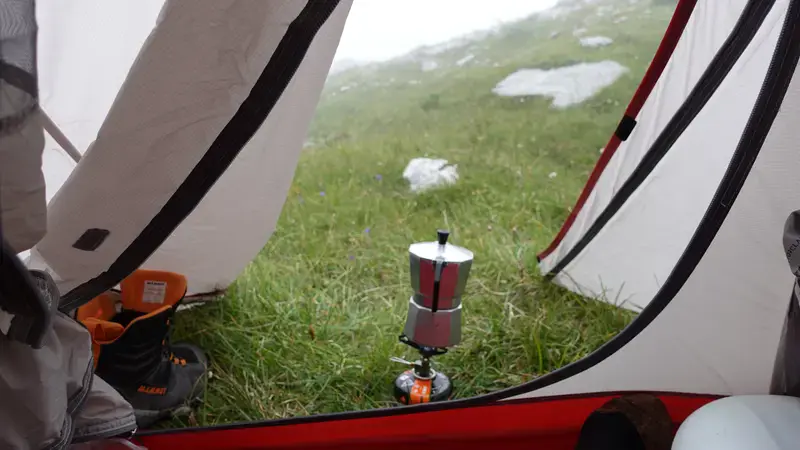
Below you can see my camp area, it is in the clouds, and I arrived here late afternoon, with enough time before the dark to put the tent in place and to prepare my coffee. The elevation here is around 2200 m (7218 ft).
During the night, there were some animals walking close to the tent, most likely ibex or Alpine goats. At some moment, probably around 1:30 after midnight, I also heard a single gunshot. It was far from clear to me what this was about.
Also, several times during the night I could hear rocks falling from the nearby Croda Marcora mountain that was crumbling for months already. One day later I was able to see such an event with my own eyes.
The weather forecast was bad, and the actual weather was the same. Frankly, I was not convinced that I would be able to get to the summit next day.
But I decided to be ready and to try, so I left everything there in the morning and started walking at 6 am. This was a late start for my standards. The reason was the weather, it looked hopeless, so I waited for the daylight to access my situation better.
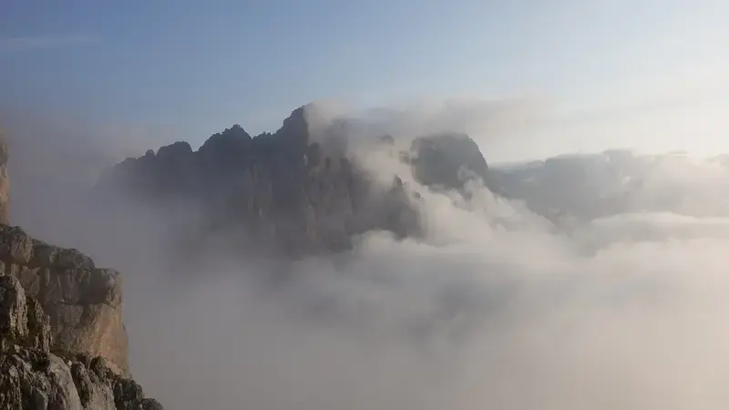
I was completely in the clouds, and the visibility was just a few meters. As I kept walking, the clouds were becoming thinner, and indeed, at one moment I was in the sun, the photo below shows that moment.
Very soon I was above the clouds, and that atmosphere you can see in the second photo which looks like a watercolor painting. It remained sunny all the way to the summit, showing once again how worthless even short-term weather prediction in the Dolomites can be.
I was convinced that I was alone on the mountain. However, as I was approaching Laste, I suddenly noticed somebody descending. I could not believe my eyes.
This was an Italian, Mattia from Calabria. When we met on Laste, he told me he started at 3 am from the valley. This in spite of the bad actual weather when he started, and in spite of a very bad weather prediction. I admit, he made my day.
We exchanged a few friendly words, and he directed me how to navigate the Laste area, we were in the middle of it. I expressed my appreciation for his efforts, and he said, “I love mountains so much, so I had to try”.
He also mentioned he hadn’t seen my tent although it was very close to the path, clearly this was due to clouds and because he passed my camp when it was completely dark.
We then continued in the opposite directions, and he was far below when I heard him calling me back, “Hey, what is your name?” I told him, and then asked for his name, so he told me, and that is how I know it. Then I heard him again “Nice to meet you Jovo”, and I replied in the same manner.
Salute Mattia, my friend, it was such a pleasure to meet you there and to see again how much desire and determination for a climb one can have. He was probably three time younger than me, I was 66, and he reminded me from my younger days.
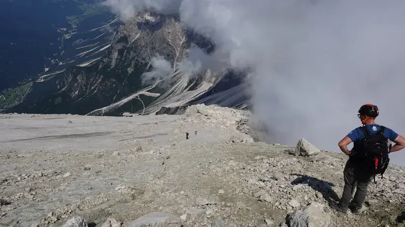
Below the summit, somebody suddenly appeared behind me. To our surprize, we both realized that we met one month earlier at Bivacco Fanton. This was Daniele, salute to you too my friend. He was going faster so he passed me, and later we joined at the summit where we stayed for 45 minutes or so.
He suggested that we descend together at least through the more dangerous parts before getting to Laste, perhaps he was worried for an elderly person like me to be alone on such a place.
This is what we did, and at Laste I suggested him to keep going without me because he was clearly able to walk much faster than me. I did not have any reason to rush in any case.
So we said goodbye to each other, but we stayed in touch later, and I hope I shall see him again.
Much later, at my camp, I collected my stuff from the camp and continued my long and slow descent towards the parking area. What a great day and what nice people, and what a beautiful mountain!
Please see more in my video:
How to climb safely: Antelao mountain climbing gear
If you decide to sleep on the mountain, you can follow my example. I carried my Naturehike Cloud Up 1 Person Tent, Sea to Summit Camp Plus Pad, Crua Outdoors Graphene sleeping bag, and Forclaz pillow.
The Naturehike tent with its inner layer has taffeta that goes quite high from the ground, and this worked great to prevent cold drafts. I also staked the fly close to the inner tent reducing the drafts even more.
This was a part of my testing of the tent in real mountaineering conditions, so here to add that cooking under the closed vestibule is not a good idea, it is too low and could get damaged.
The pad was thick and I did not feel the cold ground at all. This was a pleasant grass as you realize from the photos, so my bed was very comfortable.
For the climb, you do not need any special equipment. There are no cables, but there are many exposed passages, therefore I would strongly advise to have a climbing helmet. I used one as you can see in the photos.
I used Mammut Sapuen GTX boots, a pair of trekking poles, and my Deuter Futura 50+10 backpack. In addition, you should always have a rain protection layer like a hardshell jacket, a rain poncho and rain pants.
Do you want to climb this mountain?
As you realize, I go solo, but I have been in this for 40 years already. This is a serious tour, so if you want to do it and to play safe, which I warmly advise, get in touch with some experts and guides who can help you getting to the summit.
Final thoughts
In summary, climbing Monte Antelao solo is a journey that tests both physical endurance and mental resolve, offering a profound connection to the rugged beauty of the Dolomites.
The challenging ascent, with its exposed ledges and unpredictable weather, rewards climbers with breathtaking vistas and a sense of accomplishment that lingers long after the descent.
My night spent camping at 2200 meters, surrounded by the sounds of wildlife and distant rockfalls, added a layer of intimacy to this adventure, reminding me of the raw, untamed spirit of the Marmarole mountains group.
The encounters with fellow climbers like Mattia and Daniele underscored the camaraderie that thrives in these high places, making the journey as much about human connection as it is about climbing the peak.
For those considering this climb, preparation is key. Equip yourself with a helmet, sturdy boots, and a willingness to navigate the mountain’s demanding terrain. The route is scarcely marked, but there are cairns, so try to locate them as you walk.
Whether you are drawn to the solitude or the thrill of the summit, Antelao delivers an unforgettable experience.
Thank you for reading. Let me know if you have questions or comments, there is a comment section below.
For more texts from the same area, please check the texts about the nearby Bivacco Fanton and also about Bivacco Tiziano and Bivacco Toso.
Please join us at our Facebook group Dolomites Visitors Hub.
Frequently Asked Questions About Climbing Monte Antelao
What is the best time of year to climb Antelao?
The ideal time to climb Antelao is from late July to early September, when snow is minimal, and trails are more accessible. However, the Dolomites’ weather is notoriously unpredictable, so check short-term forecasts and be prepared for sudden changes, especially in the Marmarole group, where clouds can obscure routes.
Are there guided tours available for climbing Antelao?
While the post describes a solo climb, guided tours are available through local alpine clubs or certified guides in Cortina d’Ampezzo or San Vito di Cadore. These tours provide expert navigation and safety for less experienced climbers tackling Antelao’s exposed scrambling sections.
What wildlife might I encounter in the Marmarole area?
The Marmarole group, including Antelao, is home to ibex, chamois, and marmots, often spotted near trails or grassy plateaus. At night, as experienced during the camping described, you may hear these animals or even foxes. Always store food securely to avoid attracting wildlife to your campsite.
How does Antelao compare to other Dolomites peaks?
Antelao, at 3264 meters, is the highest peak in the Marmarole group and one of the most challenging in the Dolomites due to its significant elevation gain and exposed ledges. Compared to peaks like Monte Pelmo or Tofana di Rozes, Antelao offers a more isolated climb with fewer crowds, ideal for those seeking solitude.
Leave a Reply