Here you have some basic information about all 10 Alta Via Routes in the Dolomites together with interactive maps that show access roads and all other details related to the routes.
The Dolomites, a UNESCO World Heritage Site in northern Italy, are renowned for their dramatic limestone peaks and extensive trail network.
Among the most celebrated ways to explore this alpine wonderland are the 10 Alta Via routes, high-altitude, multi-day treks that traverse stunning landscapes, connecting mountain huts and bivouacs.
Below is an essential overview of each route, highlighting starting and ending points, elevation extremes, and accommodation options, with special equipment noted where required. General equipment for all routes is outlined separately.
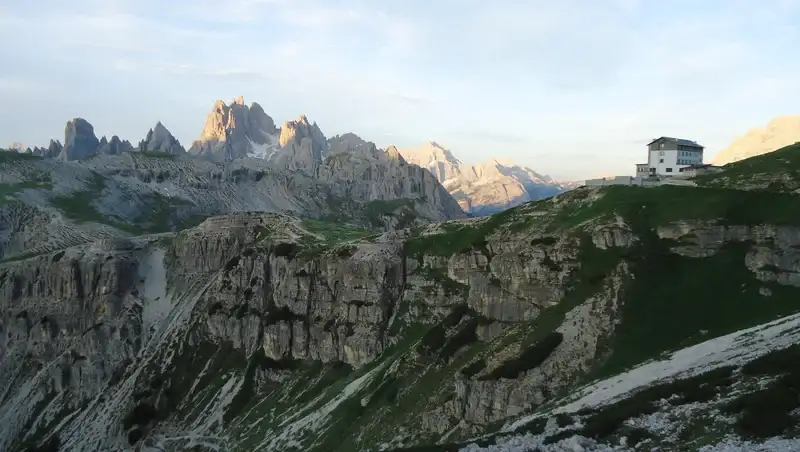
Note that some Alta Via routes cross each other or share some short sections. The picture below shows one of such points at Tre Cime di Lavaredo. This means that sometimes you can switch from one route to another.
The directions regarding start and end points given below are based on what people mostly do when they walk the routes. But of course, you can reverse start and end points and walk the routes as you wish.
Observe also that various sources may give different numbers for the length of the route, different highest points, and also different numbers for huts and bivouacs.
But such highest points may sometimes be optional, and the route length and the number of shelters may be affected by the fact that there are usually many variants of the same route, so do not be worried if you see some small discrepancies.
Alta Via 1: The Classic Dolomite Traverse

- Start: Braies lake.
- End: Belluno.
- Typical time needed: 12 days.
- Trail length: about 125 km.
- Huts on the main route: around 22.
- Bivouacs on the main route: 1.
- Longest section: from Lagazuoi hut to Palafavera, 7th leg, crossing time 6 hours.
- Shortest section: from Braies Lake to Biella hut, 1st leg, crossing time 3 hours and 30 minutes.
- Total altitude gain on ascent: about 7300 m.
- Total altitude on descent: about 8400 m.
- Maximum altitude: Lagazuoi hut, 2752 m.
- Minimum trail altitude: Belluno, 389 m.
- Opening period of the shelters: from June to September.
- Maps: Tabacco maps 1:25000
- No. 03 Cortina d’Ampezzo and Ampezzane Dolomites.
- No. 015 Marmolada-Pelmo-Civetta-Moiazza.
- No. 024 Prealps and Bellunesi Dolomites.
- No. 025 Zoldo, Cadorine and Agordine Dolomites.
- No. 031 Dolomites of Braies.
- Special equipment: none. Via ferrata gear only for optional side routes.
Here you have AllTrails Alta Via 1 interactive map:
Alta Via 2: The Rugged High Route
- Start: Bressanone (Brixen).
- End: Feltre.
- Typical time: 13 days.
- Trail length: about 180 km.
- Huts on the main route: more than 21.
- Bivouacs on the main route: 2.
- Longest section: from Feltre Bivouac to Dal Piaz hut, 11th leg, crossing time 9 hours.
- Shortest section: from Treviso hut to Cereda Pass 9th leg, crossing time 4 hours and 30 minutes.
- Total altitude gain on ascent: about 11300 m.
- Total altitude difference on descent: about 11200 m.
- Maximum trail altitude: Farangole pass, 2932 m.
- Minimum trail altitude: Feltre, 324 m.
- Opening period of shelters: from June to September.
- Map Tabacco 1:25000
- No. 06 Val di Fassa e Dolomiti Fassane.
- No. 07 Alta Badia-Arabba-Marmolada.
- No. 015 Marmolda-Pelmo-Civetta-Moiazza.
- No. 022 Pale di San Martino.
- No. 023 Alpi Feltrine-Le Vette-Cimónega.
- No. 030 Bressanone/Brixen-Val di Funes/Vilnöss.
- Special equipment: Via ferrata gear and glacier equipment (helmet, harness, crampons, ice axe) for eventual Marmolada ascent.
More details in this AllTrails interactive map:
Alta Via 3: The Dinosaur Trail
- Start: Villabassa (Niederdorf).
- End: Longarone.
- Typical time: 8 days.
- Trail length: about 100 km.
- Huts on the main route: around 8.
- Bivouacs on the main route: 2.
- Longest section: from Villabassa-Niederdorf to Vallandro Refuge.
- Shortest section: from San Vito di Cadore to Venezia Refuge, 3 hours and 30 minutes.
- Difficulty: hiking, equipped trekking.
- Total altitude gain on ascent: about 6200 m.
- Total altitude difference on descent: about 6800 m.
- Maximum trail altitude: Forcella Ciadin del Loudo, 2378 m.
- Minimum trail altitude: Longarone, 474 m.
- Opening period of the shelters: from June to September.
- Tabacco maps 1:25000
- No. 03 Cortina d’Ampezzo and Ampezzane Dolomites.
- No. 025 Zoldo, Cadorine and Agordine Dolomites.
- No. 031 Dolomites of Braies.
- Special equipment: Via ferrata gear for technical sections.
- Here you can read a very detailed report about Alta Via 3.
More details in this AllTrails interactive map:
Alta Via 4: The Via Ferrata Challenge
- Start: San Candido (Innichen).
- End: Pieve di Cadore.
- Typical time to complete: 4-7 days.
- Distance: 92 km.
- Elevation gain: approximately 4500 m.
- Elevation loss: 4500 m.
- Highest point: Forcella del Ghiacciaio, 2584 m.
- Difficulty: moderate to challenging.
- Huts: around 9.
- Bivouacs: around 3.
- Special equipment: Via ferrata gear (helmet, harness, lanyard) mandatory for multiple sections.
- An incredibly detailed report (in Dutch) is available in this text.
Here you have a video with both Alta Via 4 and Alta Via 5, please have a look:
Alta Via 5: Titian’s Path
- Start: Sesto (Sexten).
- End: Pieve di Cadore.
- Typical crossing time: 7 days.
- Trail length: about 90 km.
- Huts on the main route: 8.
- Bivouacs on the main route: around 4.
- Longest section: from Tiziano hut to Musatti Bivouac and to Voltolina Bivouac, 9 hours.
- Shortest section: from Carducci hut to Ponte da Rin, 3 hours.
- Difficulty: trekking, equipped trekking.
- Total altitude gain on ascent: about 5700 m.
- Total altitude difference on descent: about 6100 m.
- Maximum trail altitude: Forcella Jau de la Tana, 2644 m.
- Minimum trail altitude: Auronzo di Cadore, 866 m.
- Opening period of the shelters: from June to September.
- Tabacco maps 1:25000
- No. 010 Dolomites of Sesto.
- No. 016 Dolomites of Centro Cadore.
- No. 017 Dolomites of Auronzo and Comèlico.
- Special equipment: Via ferrata gear for exposed sections.
- To find out more, please read this detailed report about Alta Via 5.
More details in this AllTrails interactive map:
Alta Via 6: Alpine Trail of Silence
- Start: Sappada.
- End: Vittorio Veneto.
- Typical crossing time: 11 days.
- Length: about 185 km.
- Huts on the main route: 7.
- Bivouacs on the main route: 2.
- Longest section: from Casera Laghét de sora to Bivacco Greselin, 8 hours.
- Shortest section: from Casera Laghét de sora to Bivacco Greselin, 3 hours.
- Difficulty: hiking, trekking, equipped trekking.
- Total altitude gain on ascent: 9000 m.
- Total altitude difference on descent: about 10000 m.
- Maximum trail altitude: 2694 m on Monte Peralba.
- Minimum trail altitude: 130 m Vittorio Veneto.
- Opening period of the shelters: from June to September.
- Tabacco maps 1:25000
- No. 01 Sappada – S.Stefano – Forni Avoltri.
- No. 02 Forni di Sopra – Ampezzo – Sauris – Val Tagliamento.
- No. 012 Alpago – Cansiglio – Piancavallo – Val Cellina.
- No. 021 Dolomiti di Sinistra Piave.
- No. 024 Prealpi e Dolomiti Bellunesi.
- Special equipment: Via ferrata gear for select passages.
An excellent description of the route you can find in this detailed report. More details in this AllTrails interactive map:
Alta Via 7: The Geological Journey
- Path: Rifugio Dolomieu al Dolada (BL) – Tambre (BL)
- Typical crossing time: 5 days.
- Trail length: about 36 km.
- Huts on the main route: 2.
- Bivouacs on the main route: 2.
- Difficulty: trekking, equipped trekking.
- Total altitude gain on ascent: about 3100 m.
- Total altitude difference on descent: about 3700 m.
- Maximum trail altitude: Cimon del Cavallo, 2251 m.
- Minimum trail altitude: Tambre, 922 m.
- Opening period of the shelters: from June to September.
- Tabacco map No. 012 1:25000 Alpàgo – Cansiglio – Piancavallo – Val Cellìna.
- A detailed Alta Via 7 description of around 55 pages you can download and read here.
More details in this AllTrails interactive map:
Alta Via 8: The South-Eastern Explorer
- Start: Feltre (province of Belluno).
- End: Bassano del Grappa (province of Vicenza).
- Typical crossing time: 4 days.
- Trail length: about 63 km.
- Huts on the main route: 1.
- Bivouacs on the main route: 5.
- Difficulty: medium and high.
- Total altitude gain on ascent: about 3100 m.
- Total altitude difference on descent: about 3200 m.
- Maximum trail altitude: Bassano Hut to Cima Grappa, 1745 m.
- Minimum trail altitude: Bassano del Grappa, 130 m.
- Opening period of the shelters: from the end of May to the beginning of November.
- Special equipment: none required.
- More information is available in this text. But see also the details in this AllTrails interactive map:
Alta Via 9: The West to East Traverse
- Start: Bozen (Bolzano).
- End: Santo Stefano di Cadore.
- Typical duration: 12 days.
- Length: 176 km.
- Total altitude gain on ascent: 11447 m.
- Total altitude difference on descent: 11742 m.
- Huts: more than 17.
- Highest point: 2613 m.
- Lowest point: 900 m.
This route traverses from the west to the east, and it crosses Alta Via 2 and Alta Via 4 routes. More details in this AllTrails interactive map:
You might want to see this video about Alta Via 9 route:
Alta Via 10
- Start: Bolzano (Bozen).
- End: Gardone Riviera.
- Length: 200 km.
- Typical duration time: 18 days.
- Difficulty: easy to medium.
- Total altitude gain on ascent: 14.461 m.
- Total altitude difference on descent: 14646 m.
- Highest point: 2782 m.
- Lowest point: 75 m.
- Special equipment: none typically required.
- An excellent description of the route you can find in this text.
More details you can find in the map:
General Equipment for All Alta Via Routes
For all 10 routes, hikers should pack:
- Sturdy hiking boots with ankle support.
- Weather-appropriate clothing (layers, waterproof jacket).
- Backpack (40-50 liters).
- Trekking poles (recommended).
- Sleeping bag liner (for huts).
- Water bottle and purification tablets.
- First aid kit.
- Headlamp.
Thank you for reading. Let me know if you have questions or comments, there is a comment box below. Please read my text about crowd on Alta Via routes and about options of going with a tent.
Subscribe to my weakly newsletter and stay informed, the subscription form is given below.
Leave a Reply