Rosablanche is not so prominent mountain in Swiss Alps, with its 3336 meters it is, in fact, a rather moderate in comparison with its neighbors on the south side like La Sale (3646), Le Pleureur (3704), La Luette (3548), and Mont Blanc de Cheilon (3870). However, it is a rather unique mountain in view of its normal north glacier routes.
[Chopin Nocturne in C sharp Minor (No.20)]
Both normal routes, from Barage de la Grande Dixence (Dix lake) in Val d’ Heremence, and from Siviez in Val de Nendaz are relatively long glacier walks. There are crevasses on the routes, in particular from the Siviez direction.
Within this page, you will find all necessary information about these glacier routes to the summit and many useful photos. I passed these routes myself so I give here first-hand details about the climb.
It may be interesting to compare Rosablanche with Barrhorn in the same region, which is far higher but in summertime it is without any snow whatsoever.
Below is a map describing access roads to the Rosablanche region.
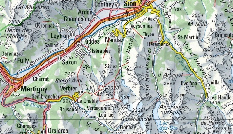
Roads
The maps above show access roads from Sion in the Wallis region of Switzerland. By car, the nearest destinations are the Dix lake in Val d’ Heremence, and Siviez in Val de Nendaz. The former is at around 1900 m altitude and later at 1730 m. Those are good mountain roads in both cases. There are some simple hotels just below the Dix Dam.
Huts
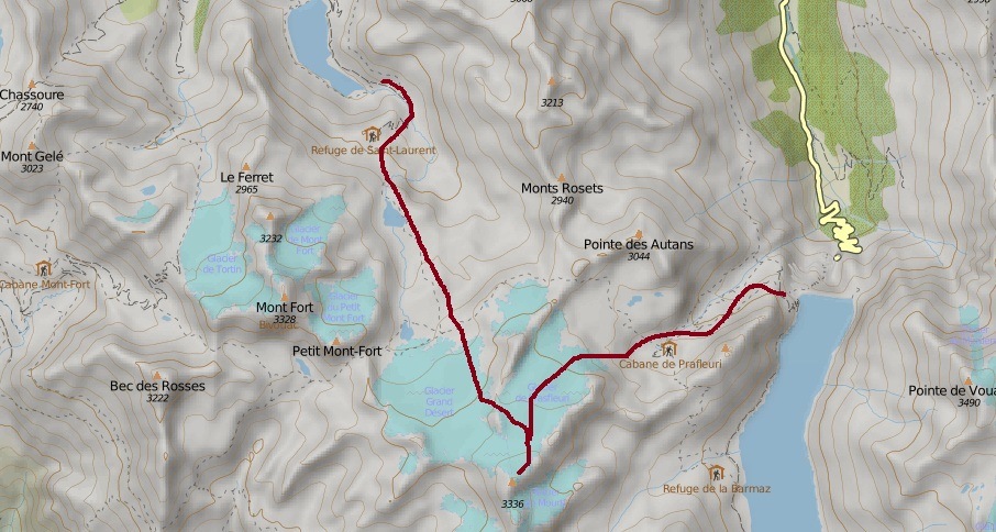
There are many huts around, at all sides of the mountains. The closest from Val d’ Heremence side are: Cabane de Prafleuri (2624 m), Cab. de Ecoulaies (2575 m), Ref. de la Barmaz (2458 m). From Siviez side, this is Ref. de St. Laurent (2485 m) above Lac de Cleuson.
There is also Cab. de Louvie in Val de Bagnes (Fionnay). This is not the complete list, a bit farther are Igloo des Pantalons Blancs (3280 m), Cab. des Dix (2928 m), and Cab. Mont-Fort (2457 m).
Routes to Rosablanche
The north-east route is over Glacier du Prafleuri, and the route from the northwest over Glacier Grand Desert. Those are simple glacier walks but there are crevasses in lower parts.
All precautions and equipment for glacier walks are required. This includes at least 12-points hybrid Petzl), and a rope and harness if you go in a group.
If you start from Siviez (1730 m) you may reach the summit in about 5 hours. You will first walk either along the road towards the lake Cleuson, the east side of the river, or you may follow a pleasant hiking trail along the west side through the woods. From the Cleuson dam, you will continue along either side of the lake following the signs to Ref. de St. Laurent.
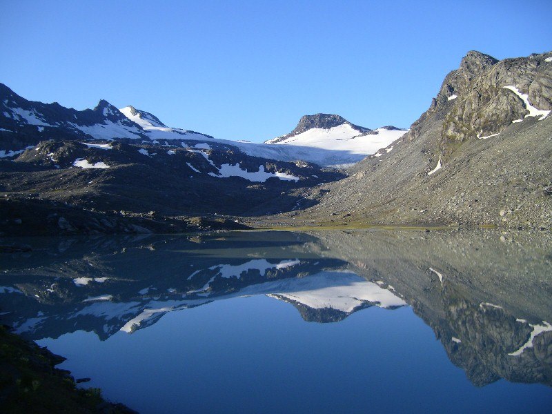
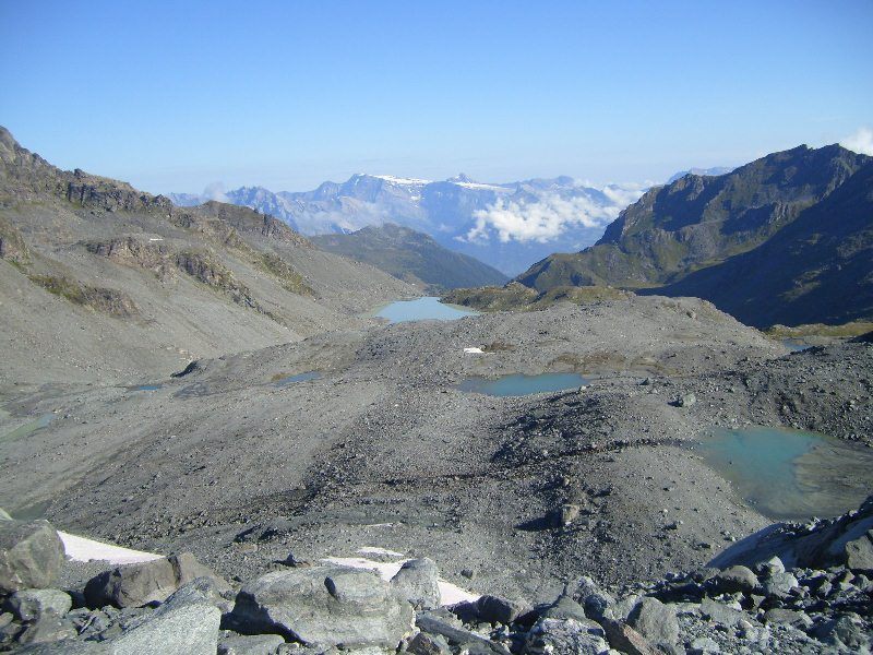
After the hut, you are on your own, no signs of civilization any longer and you should continue toward the lake Grand Desert which is at around 2650 m of altitude. I dream to go there again for camping and to walk around.
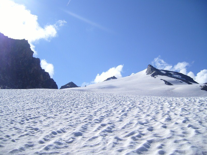
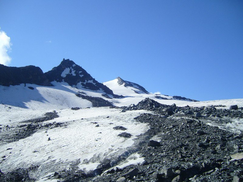
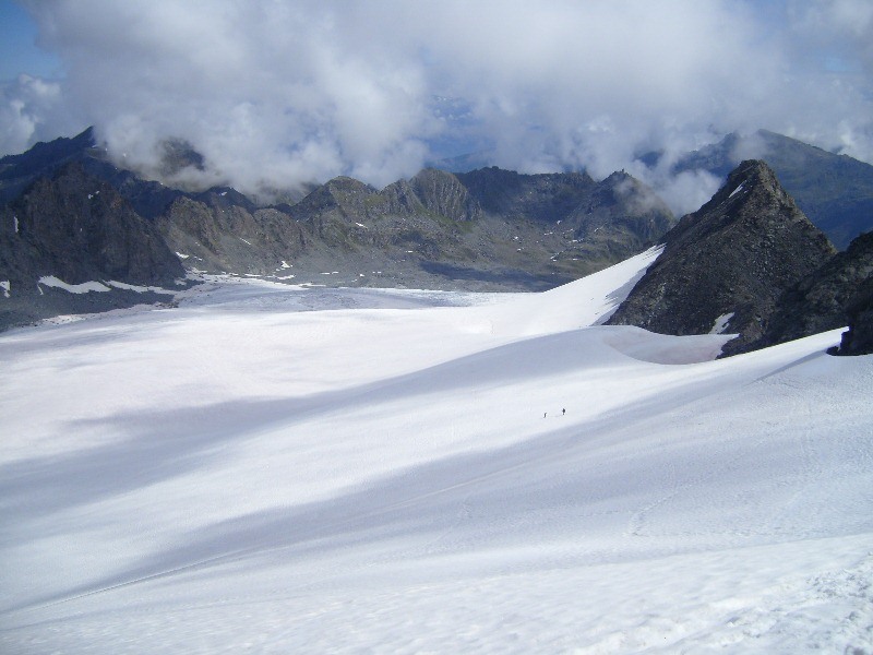
The glacier Grand Desert is visible from there, and you will continue to the southeast and at one point you will cross the route which goes to Col de Louvie in the southwest direction and to Col de Prafleuri in the north-east direction. Early in the season, the crevasses on the glacier may not be visible but there are many, I have seen some pictures when it is without the snow.
For this reason, I would recommend keeping left as much as possible close to the rock of Mt. Calme. This is because there is far more snow in this area and crevasses are effectively closed all the time.
From Dix lake, you should follow the signs toward Cab. de Prafleuri. You can get to this hut also from the south, i.e., from the La Barma hut on the west side of the lake Dix. This implies passing Col des Roux (2804). From Cab. de Prafleuri you should continue toward an area where the material was excavated for the building of the barrage on the Dix lake.
The summit of Rosablanche will soon be in sight and it will remain so for the rest of the climb. You will walk along the Prafleuri Glacier toward the summit. Cannot give timing for the ascent because I only descended partly this way, but you will see from the map that this part is shorter than the route from lake Cleuson.
About necessary equipment
This is a glacier climb, so here is the list with some items you need:
| Recommended | Essential |
|
Note, the type of boots depends on the type of crampons, read more in my separate text.
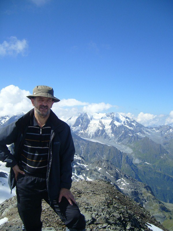
My climb
For me, this was a solo climb from Siviez, in July 2009. I started at 4:30 am, I passed Lac de Cleuson and Ref. de St. Laurent, and I was at Lac du Grand Desert at 7:15. At 8:35 I crossed the point where the path splits towards Col de Prafleuri and Col de Louvie. There were no obvious signs for Rosablanche but I could guess the direction.
I saw just a few clearly visible crevasses in the lower part but I must say I was terribly concerned about them. The snow on the glacier was not hard. I used crampons. Later at the summit, I have seen a group of three roped girls without crampons. I arrived at the summit at 10:30 am.
I spent about 40 minutes on the summit, the weather was simply perfect. I descended along the Glacier Du Prafleuri, this was scary again of course although a beautiful walk, and then I continued up to Col de Prafleuri. I was at the Col at 1 pm. From there, I descended in the Siviez direction, passing a few small and beautiful glacier lakes.
Far below, just after I passed Ref. de St.Laurent, the rain started. I had all waterproof stuff but I still took a shelter at a small shepherd hut above Lac de Cleuson. There was a shepherd there, he even offered me tea from mountain herbs as he said. I thanked but said no need. Tired, sitting on the porch, and with a nice noise of rain on the roof, I even took a nap for a few minutes.
Later, I continued and arrived in Siviez at 18 h. What to say more, it was a beautiful full-day walk. I met just a few people all the day long. I would highly recommend it for everybody, but please remember crevasses; they are there even if you do not see them. Better not to go solo if possible.
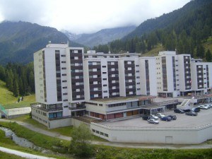
In this particular case, I was renting a flat in the building on the photo which you can see here left. The hiking routes start immediately from the building. There are flats of various size in the building and I am sure you will find something suitable. You may find a flat for less than 200 E per week for two people.
So to summarize, routes to Rosablanche from the north require glacier equipment, crampons, ice axe, rope. There are crevasses, therefore it is better not to go solo.
If you are in the area and want to play it safe and hire a guide, please follow this link, they will find you somebody from the local area who will take you safely to any of the summits around.
Please leave some comments below, share your thoughts if you have been there or if you plan to go someday.
In the following YouTube video you will see the approach from the south:
Janko says
Hello Jovo,
Thanks for your amazing and very informative article about Rosablanche. At the moment we are in north west England where you can run across mountains – they are not big enough to cause problems. We will be staying in Siviez and I am putting itinerary for our trip. We want to climb this peak crossing Grand Dessert Glacier depending on weather ( if the weather turn nasty to turn via Col de Louvie and then Col de la Chaux to climb Mont Fort ) following your advise to keep to left beside Mont Calme. Are crevasses only dangerous during lower part of glacier or when you are exposed above Petite Mont Calme and peak itself crevasses are possibility ?
Jovo says
Hi Janko, great to hear from you. The glacier is not steep at any place so yes only crevasses can be a problem, but if you are roped in a group all will be fine, they will be visible in late season. The upper part is a bit steeper but I have seen people without crampons. There are no exposed sections anywhere.
I do not know about your plans for Mont Fort, did not pass the route from that side. In some other occasion, I have approached Mont Fort from the other side. It would be great to hear about it. Note I have an open invitation for guest authors, so if you have time please send me some text with first-hand information. This is very useful for everybody.
Are you from former Yugoslavia? The name is Serbian, this is my native language.
James Stern says
Wow! Thank you for the information, the music, and the excellent website as a whole. This website is loaded with information that is accessible to people like me who have almost no experience mountain climbing. I am going to bookmark your site. I appreciate your honest reviews and the depth of each article. Keep up the great work!
Jovo says
Hi James, thank you, much appreciated. I am glad that you like my text. This is all my own experience of course and I love to write about mountains. You noticed my music, thank you.
Steve says
Very cool website. You have a great array of images that, I think, are well placed on the blog. Including the maps of areas you were talking about was a good move as well so that people interested in the place could get an idea where it is. I think your inclusion of you personal experience with that climb helps to really “humanize” the site and let people feel like they’re making a friend. I also appreciated the great list of links related to your website and blog for people to be able to do further research if they want.
Jovo says
Hi Steve, thank you, great pleasure to read your comment. In this text I describe my own climb to Rosablanche, the same is with all other pages within this site. This is all first-hand experience, I write only about mountains I climbed myself.
Dominic says
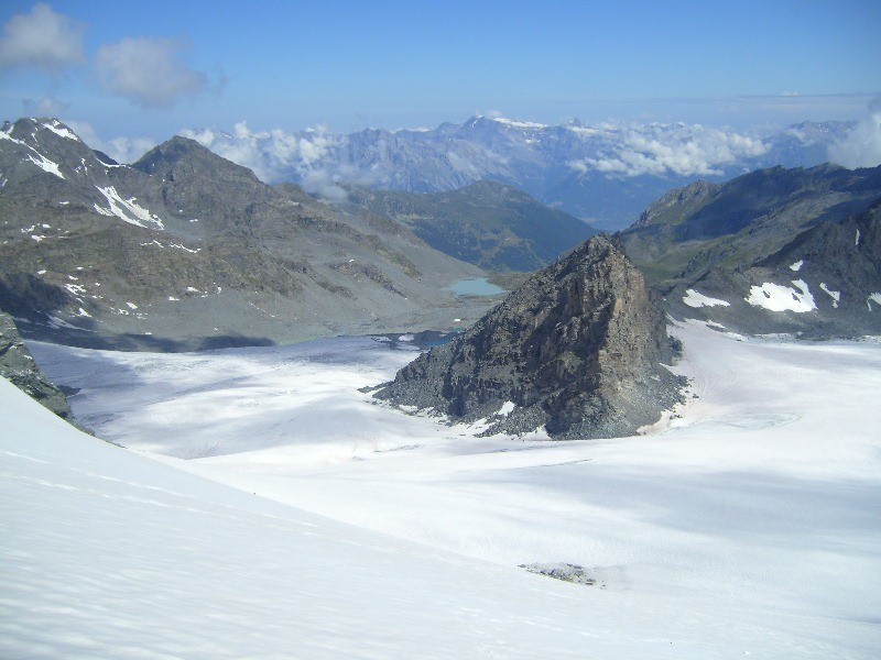
My goodness…. the view of the Lake Grand Desert towards Rosablanche is simply breathtaking. This is just my view from my laptop. I imagine that it must be even better if I am there physically. By the way, you mentioned that this particular is a glacier climb am I right? Does it mean that it is not as steep to climb as you mainly passing through ancient ice glacier? Sorry I have to ask since I am not familiar with mountain climbing, whatmore if glacier is involved. Would be great if you can maybe enligtened me a bit on this? Thanks
Jovo says
Hi Dominic, thank you for reading my text. You are right about that photo and about views in reality, they are simply fantastic. You have seen my photos, so those north routes are not so steep. But glacier routes can be very steep, it all depends on the particular mountain.
Cindy Fielding-Smith says
Jovo, after a visit to your website, and about Rosablanche, I realise I have not really even begun to know about mountain climbing.
I live in Australia, and climb the local ‘hills’ as you might say, in comparison to your amazing mountains.
Just reading all about the climbs and best of all, how it was for your climb, is exhilarating to say the least.
I am inspired to do some climbing in the future, and look forward to the opportunity to climb some of your recommended mountains.
Thank you for sharing your passion…..truly inspirational!
Best Regards
Cindy
Jovo says
Hi Cindy, I must say your words are equally inspirational. There is beauty in every mountain if our soul is open for it. So enjoy those around you even if they are much lower. Many thanks for the comment.
David says
Thank you, Jovo, for sharing your love of mountain climbing. Your trip up Rosablanche was beautiful, and I appreciate the opportunity to share it vicariously through your journey. I am writing from Iowa in the U.S., land of flat to gently rolling corn and soybean fields; so the Swiss alps look pretty amazing. I realize you were taking some risks doing this trip alone, knowing the risk of crevasses. How did you prepare for the possibility of stepping into a snow covered crevasse?
Jovo says
Hi David. Great to read your comment. My answer to your question may be disappointing to you: I did not. I stepped on the glacier hoping for the best. We have a proverb in my native language that God takes care about fools. It worked for me so far.
TheDopestMatrix says
WOW! So you took these photos? that’s awesome! I want to go to the Swiss Alps one day! 🙂
also, I don’t get what you mean by huts, are they like peoples homes you stay at like at a hotel? Or are they like shelters in the wilderness? LOL
Thanks for sharing!
Matt TheDopestMatrix
Jovo says
Hi there, thank you for reading my page about Rosablanche mountain. Yes, I took all photos, I do not borrow from the Internet. Huts and shelters are described a bit in my another text, have a look. Those are not hotels in any case.
Emily says
hi there!
I only wish I could go to Switzerland! My sister is going in the fall though so I will pass along the info. Very detailed post you wrote. Wonderful that you could include your own personal experience. I loved the anecdote with the shepherd offering you tea. It seems like the view at the top is absolutely breathtaking
Jovo says
Hi Emily, great that you had time to see my text and I am grateful for the comment. Everything there is indeed breathtaking. Jovo