Hochfeiler or Gran Pilastro is the highest mountain in Zillertal Alps. It is located on the border between Austria and Italy. The normal route to the summit goes from the south Italian side, and this is my only reason for placing this mountain in the Italian Alps within this site.
Basic data about the mountain:
- Height: 3510 m.
- Coordinates: 46°58′22″N 11°43′34″E (46.973092, 11.727834).
[F. Tarrega: Tango]
Route description
The route starts from the road, at some 1700 meters above the sea level. You arrive here by following the road to San Giacomo or St. Jacob, from Vipiteno or Sterzing, which is on the south side of the Brenner Pass.
You realize that all places here, including the mountain itself, are with two names, the German and the Italian. You will follow the signs for Vizze valley (Val di Vizze, or Pfitsch).
After you pass the last houses in the tiny Sasso village, the asphalt road ends up and you will continue along a rather good macadam road which you will follow for another couple of kilometers.
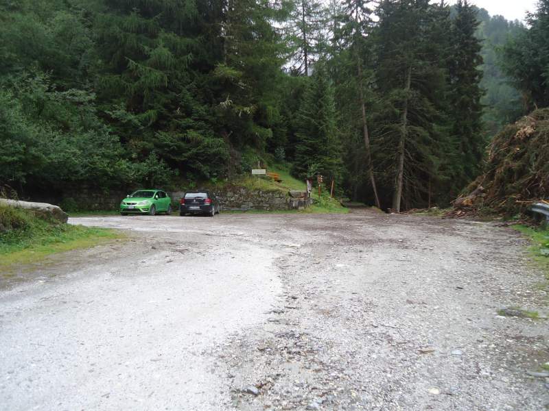
This is the general direction towards the Vizze pass (Passo di Vizze, Pfitscherjoch). The road is not completely open to the public, you can follow it only till the 4th turn where there is a parking at the start of the route to Europa hut.
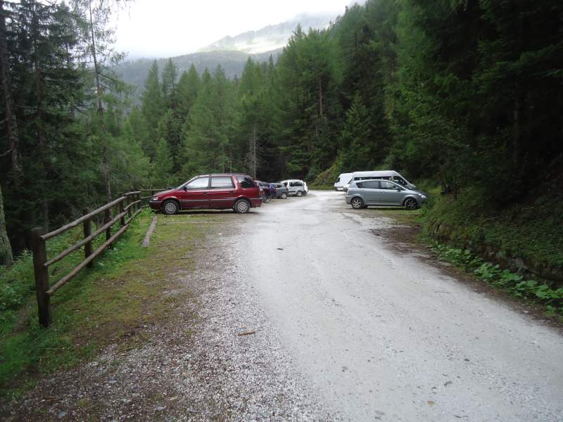
The car parking for the Hochfeiler route is exactly at the beginning of the route, but it is quite small. This is at the third turn above the valley. But there is a bigger one just 300 meters down the road, and this was my actual start point.
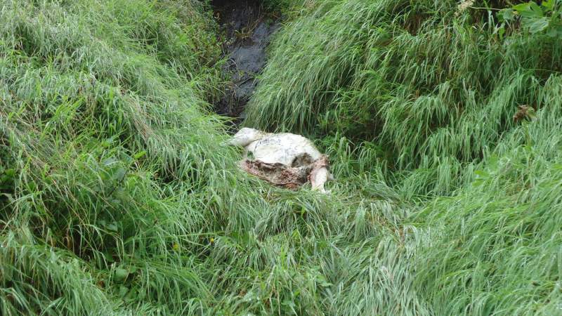
The parking is surrounded by a nice pine forest, there is a water stream running exactly at the spot, I am not sure if the water is indeed drinkable but it looks so, but think about the photo above.
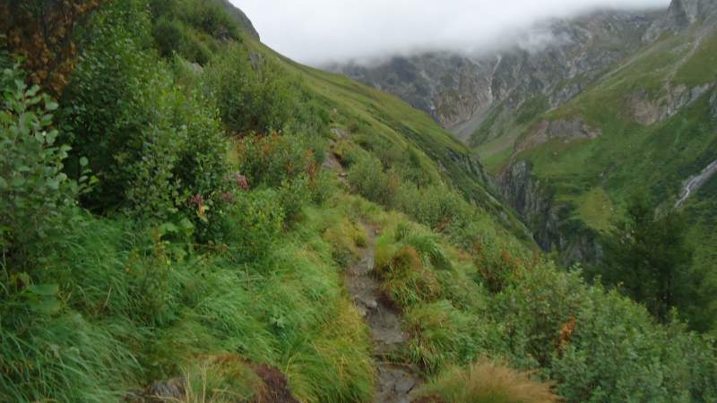
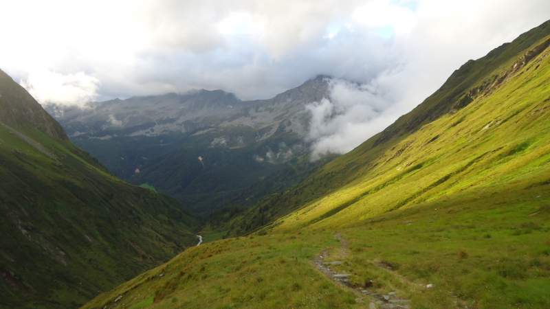
As soon as you start your tour, you will enter the woods and you will turn right and descend toward a bridge that goes over a very noisy water stream. After that, you will follow the narrow path through the woods, then through the bushes, and then over meadows and grassy slopes high above the valley which is on your right side most of the time.
You will gradually gain altitude all the time. So this is a lengthy approach and this seems to be the only one. The line on the map below is far from showing the exact route, it only depicts the general direction.
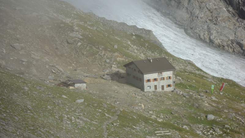
At some point, you will pass the spot where the route splits and one branch of it continues towards the Hochfeiler hut, while the other goes to the left towards the summit.
If you continue towards the summit, you will get to yet another point on a rock high above the hut, where the route again splits and you will see one branch of it going towards the hut.
So now if you continue towards the summit there are no other routes, the direction is obvious, and you will need some 2-3 hours from this point to the summit.
Here is a video with some people climbing Hochfeiler also directly from the road like myself. But they have had just perfect weather condition, have a look:
The hut
- Phone: +39 0472 646071.
- E-mail: info@hochfeilerhuette.it
- Site: www.hochfeilerhuette.it
- Beds: 94.
- Winter room: yes.
- Access time from the road: 3 hours and 10 minutes.
Equipment
There are no exposed sections on the route to the summit, no fixed cables or ropes. You do not pass glaciers (although they are around you), and in the summertime, the route is free of snow. Therefore no special equipment is needed to climb Hochfeiler. Have a pair of hard mountaineering boots, and I warmly suggest you have trekking poles. Here is my summary:
| Recommended | Essential |
|
|
Permits & fees
No permits. Car parking is free. Note, there is no space to pitch a tent around the car parking, and I am not sure of this is allowed at all. I slept two nights in the car, and I was not the only one.
Supplies
If you plan to buy some food or fuel, you’d better do this in Vipiteno (Sterzing). I have not seen any shop in the villages along the road, except for one pizzeria.
My climb to Hochfeiler – Gran Pilastro
I did it in a hard way, directly from the road. I ascended from the car parking and descended to the same spot without staying in the hut. For this, I needed a bit more than 10 hours in total, 6 hours for the ascent and around 4 for the descent. If you are in a good shape and some 20-30 years younger than me, I am sure you can do it considerably faster. My story is as follows.
I arrived at the car parking from Belgium at 8 pm. After spending the night in the car, I wanted to start at 5 am, but it was raining all night and the same was in the early morning. It looked very bad. So initially I gave up. But it was obvious I would have a long day and next night till a possible attempt next day, so later, shortly after 10 am I decided to go regardless of the rain.
I had waterproof pants, a jacket and gloves and the weather was changing all the time, so I was changing my clothes 6 times during the climb. This was rather annoying and took a lot of time. In the lower part of the route, I met several groups of people who were coming from the Hochfeiler hut.
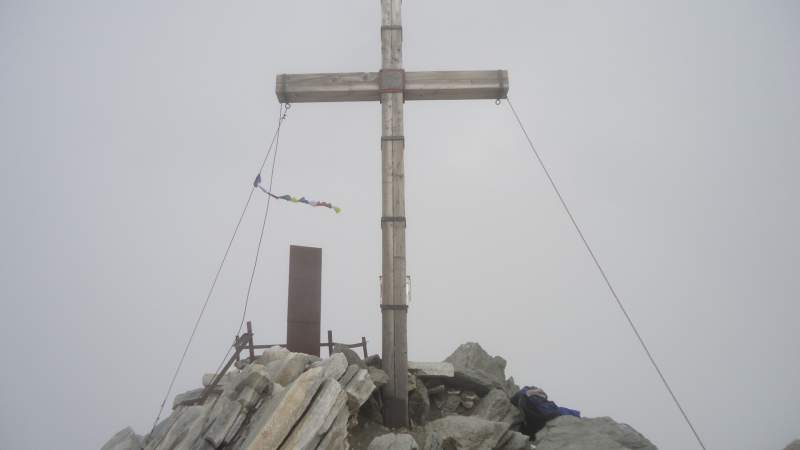

It seemed that the only people who actually climbed the mountain that day before me were a German man and a girl from the Check Republic. I met them at the spot where the route splits and one branch of it descends towards the hut. I was taking the rest at that spot and was watching the hut when they appeared from the clouds above. Note, the first (zoomed) photo with the hut above was taken from that point. They descended towards the hut and I continued up. There was nobody else on the mountain, I had it for myself all the way up and down. This was not so surprising in view of the weather conditions.
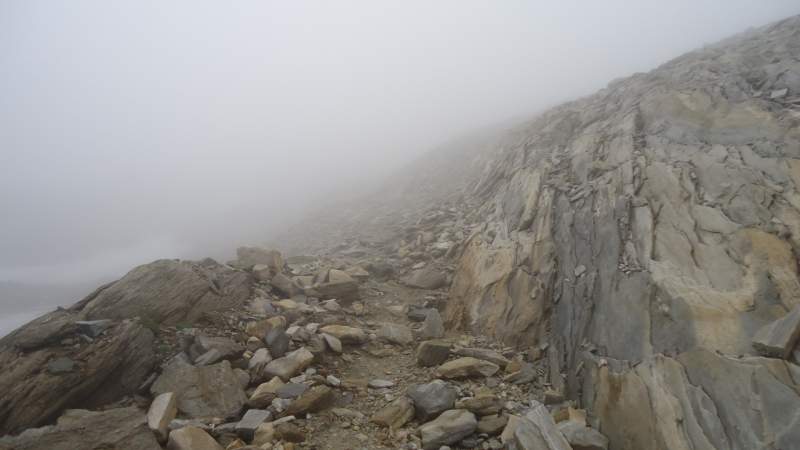
From this spot above the hut, it is a long walk, some 3 hours or so. I was completely in the clouds all the time and with no views at all. There are no signs in this upper part, only cairns, plenty of them, and they do the job, so I did not have problems to navigate in spite of so low visibility.
I must say it was harder than I expected, most likely partly due to the fact that I was not acclimatized at all. I arrived from the sea level the night before.
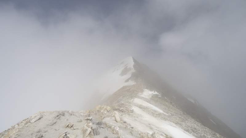
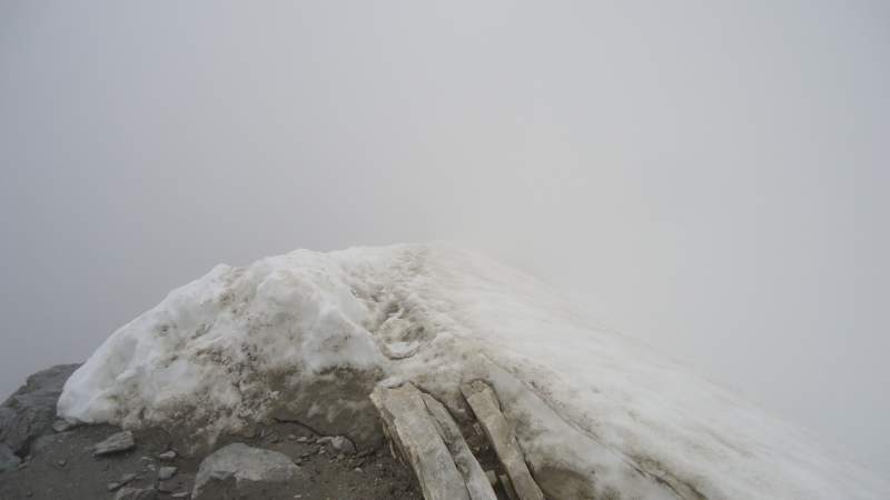
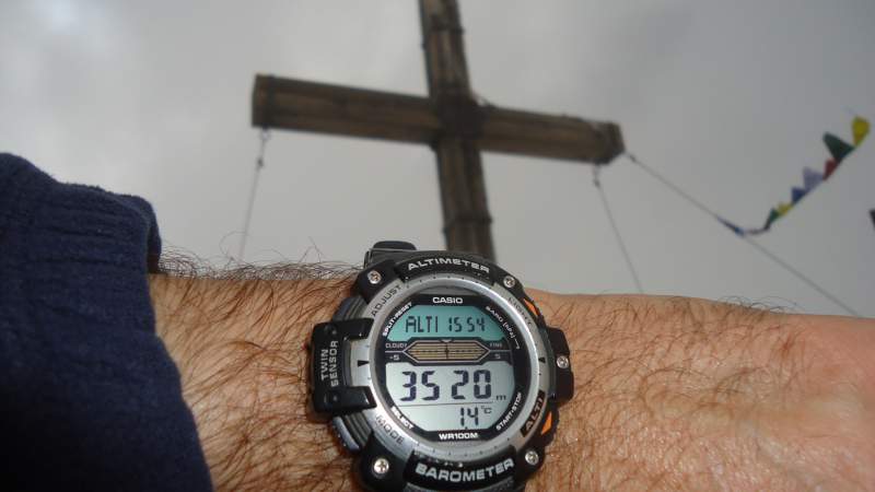
The final ridge was with a lot of very soft snow, and I had to go along the right slope through the rock. I was on the summit just a few minutes before 4 pm, see one of the pictures above. Did not stay long on the summit because it was late already and the weather was becoming even worse, it started snowing and it was very cold.
So after a long walk back and a lot of rain, I was at the car after 8 pm, totally wet and exhausted.
Conclusion
So what to say more in the end of my report about Hochfeiler – Gran Pilastro tour? I had this mountain in the list for many years. As you realize, the weather conditions were far from favorable, cannot show you much of the beauty around, sorry for this. But I do not regret it, I enjoyed every minute of the tour.
This is indeed not a technical climb, but do not underestimate it if you do it the same way as I did it, directly from the road and back to the road. It is long and you will need a lot of stamina. I have included this mountain in my list of best mountains to climb in Italy in one day.
How to compare Hochfeiler with some other mountains in the Alps? By the height, it is a bit higher than Kreuzspitze which is on the other side of the border in Austria, but it is more demanding because of the access route. It is also a bit lower than Barrhorn in the Swiss Alps, but again I find it more demanding. None of these peaks has snow or glacier passages and this is what makes them similar, apart from the height.
Thank you for reading. It will be great to hear from you, there is a comment box below.
Mindy says
Hi! Thank you for this informative blog posting. What time of year did you do this hike?
Jovo says
August 22, yet lots of snow on the final ridge, and no views at all, pity. If you go, send some pictures to add, I have an open invitation for guest authors.