• Home
  • ABOUT
  • HOW TO START
  • ALPS
    • Austrian Alps
    • German Alps
    • Italian Alps
    • Slovenian Alps
    • Swiss Alps
    • Huts and Shelters
    • Roads and Passes
  • TENERIFE TOURS
  • ABOUT EQUIPMENT
  • FAQs
  • WRITE FOR US

Mountains For Everybody

Site about mountaineering, climbing and equipment, for those who love mountains

  • Outdoor Sleeping
    • Tents
      • Solo tents
      • Tents for 2 People
      • Tents for 3 People
      • Tents for 4 People
      • Tents in general
    • Tarps and Shelters
    • Sleeping Bags
    • Sleeping Pads
  • Backpacks
    • Day Packs
    • Mid-Size Packs
    • Large Packs
    • Kids & Youth
    • Packs FAQs
  • Clothing
    • Men’s
    • Women’s
  • Footwear
    • Men’s
    • Women’s
    • Insulated
  • Gear
    • Camp stuff
    • Lamps
    • Poles
    • Filters
  • Newsletter subscribe

Igueste de San Andres – Playa Antequera Tour – Tenerife Hiking

Last Modified: 01/13/2025

Here is my short description of the Igueste de San Andres – Playa Antequera Tour, from my Tenerife hiking collection. This is a whole day tour in a remote part of the island without any access roads, so you will enjoy the nature of the island.

First view of Playa Antequera from the hill above Igueste de San Andres.

The tour overview

Igueste de San Andres is a remote village on the east-southeast side of the island, but with a good bus connection so getting there from Santa Cruz is easy. Take the bus 945 and enjoy scenic views along the south-east coast. Alternatively, use the car and park anywhere in the village.

I am writing this a few years after I did the tour, so I forgot some details, but here below are some photos which will help both you and me.

At the beginning of the route above Igueste de San Andres. The scenic road towards Santa Cruz is far behind.

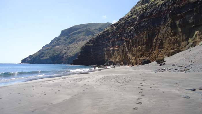
This is a circular tour but you can make it differently, just go to Antequera and back if you prefer so. Enjoying the Antequera beach is optional, dependent on the season. I was there in September, the period when the sea water is the best for swimming, so I stayed there for a couple of hours.

The area behind the Antequera beach is a protected Ijuana zone which I described in my separate text. So this is an empty quarter all the way to Chamorga.

Here is the Wikiloc map and the route I passed is marked. The indicated timing is probably correct, perhaps you can do it faster but better not doing so. This is an area of exceptional beauties so why rushing, better enjoy the day and make it a long whole day tour.

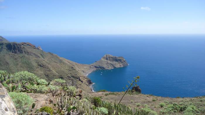
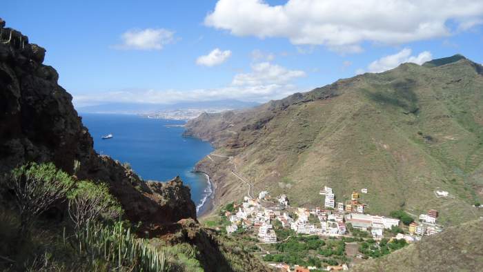
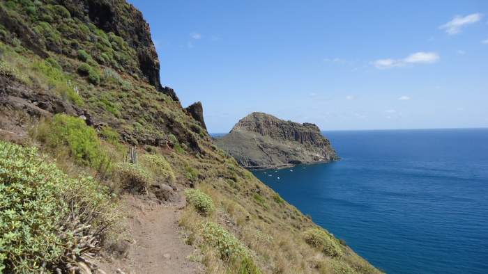
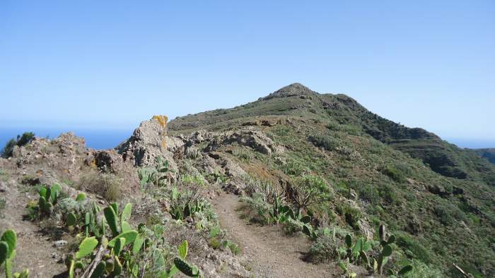
If you come by bus, go to the last stop and then continue walking between the houses in the east direction and follow the signs for Faro. But do not continue to the faro (lighthouse), rather turn up the hill, there is a wide path and in some 30-40 minutes you will be on the top of the hill and Igueste will be below you in the west direction. From here you will have breathtaking views and the big part of the road towards Santa Cruz will be visible. You have seen a couple of photos above, they are taken from the spot. The elevation here is around 420 meters above the sea.

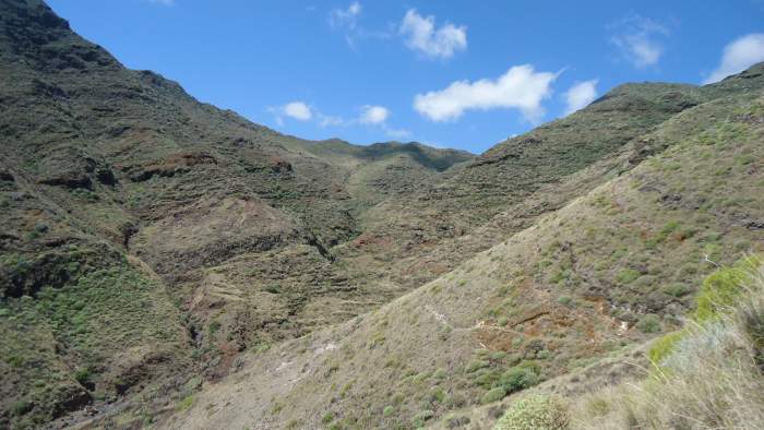
Now you start descending into a gorge on the east side of the hill, there is a very tiny path which you should follow; it goes in the north direction opposite to the sea. The photo below shows what you will see. When you get to its lowest part, the path turns towards the sea and now it is more visible and wider.

Descending the hill and Antequera in the distance on the right.

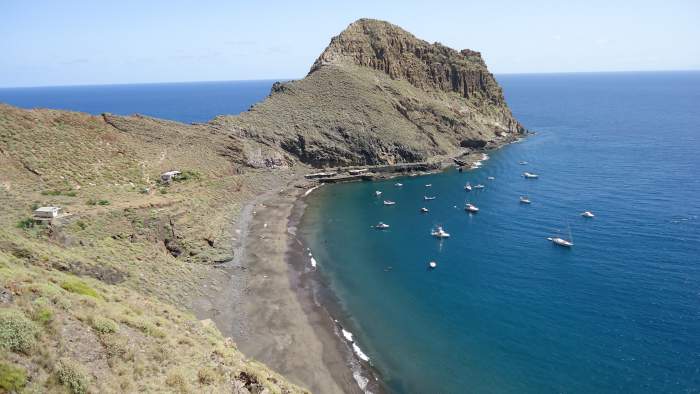
I did not check the time so have no idea how much time is needed to get to the beach, the weather was just perfect, so I did not care about the timing. But it probably took me 90 minutes or so. There was nobody on the route, and there were only a few people on the beach in the distance, but this is a large area so I had a big part of the beach for myself.

View back.
View back.
Approaching Antequera.

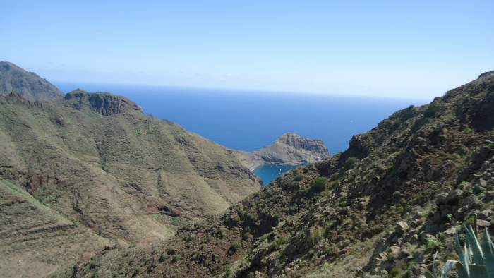
Here are a few photos taken as I was approaching the Playa. The weather was just perfect and the view of Antequera was breathtaking, you realize this from the pictures. You see a number of boats but the beach was quite empty. There are no roads here so the only access is from the sea:

Above Antequera.
Above Antequera.
On the beach.
On the beach.
I took a long rest here.
I took a long rest here. Can you imagine why?

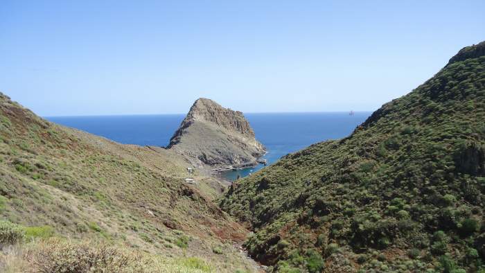
After the beach, I continued along another gorge (Barranco de Antequera) which goes in the north-west direction, see the picture below. So this is now harder because you will be gaining the altitude up to the point which is 520 meters above the sea (this according to my Casio watch which was showing me the elevation). The Wikiloc map shows nearly the same. The highest point is shown in the picture below.

Continuing along Barranco de Antequera, the second part of the tour.
This is the highest point of the route, around 520 meters above the sea.
This is the highest point of the route

At this highest point, Las Casillas houses are close above you, but you will turn to the south and start descending to Barranco de Igueste and towards the village. This is still a long way to go, so if you are with kids they might find it very annoying. I have had such experiences with kids, but this was decades ago and in some other country.


Equipment

You will have to carry water for you, it is not available on the route. The same is about food. As far as I know, there are no shops or restaurants in Igueste or anywhere close to it.

As for the equipment, have some sun hut, glasses, I have used trekking poles as usual. Any hiking shoes or boots will be good enough, this is a walking tour, the path is always visible. Any day-hiking backpack will be fine, I had my old Deuter Futura.


Thank you for reading, please let me know if you are familiar with this area, and share your experience with us. There is a comment box below, so use it for that purpose or if you have any question. Have a nice day.

Spread the love

Mountains for Everybody site is reader-supported. This means that some of the links in the text are affiliate links, and when you buy products through our links we may earn some small commission to keep running the site. Filed Under: Hiking tours, Tenerife Tagged With: Tenerife hiking

Leave a Reply Cancel reply

Your email address will not be published. Required fields are marked *


My photo on the summit of Jalovec.Hi everybody and welcome to my site which I nurture with love and passion. Here I describe my own climbs and give reviews of equipment. I hope you will enjoy it. More about the site and about me here.

Categories


Cookies Statement

In this site we do not have any cookie tool. But we do use services by third parties that either use cookies or may be doing so, yet we do not have any control of it. This is covered in their privacy policies. For more details please check in our Privacy Policy page.


  • Contact
  • Privacy Policy
  • Affiliate Disclosure

My Most Memorable Tours

  • Magic Moments On Mount Teide Tenerife
  • Climbing Weissmies solo
  • Climbing Mount Fuji
  • Climbing Zugspitze solo
  • Lagginhorn my first 4000er

Recent Posts

The Physiological Impact of Thru-Hiking featured picture.

The Physiological Impact of Thru-Hiking: Body’s Response and Effects

Are Canvas Backpacks Good for Hiking featured picture.

Are Canvas Backpacks Good for Hiking?

Why Is There a Gap Between My Back and Backpack featured picture.

Why Is There a Gap Between My Back and Backpack?

Huts and Bivouacs in Dolomiti di Brenta Alps: Interactive Map featured picture.

24 Huts and Bivouacs in Dolomiti di Brenta Alps: Interactive Map

What Is the Easiest Way to Deflate a Self-Inflating Mattress featured picture.

What Is the Easiest Way to Deflate a Self-Inflating Mattress?

Affiliate Disclosure

I am a participant in the Amazon Services LLC Associates Program, an affiliate advertising program designed to provide a means for sites to earn advertising fees by advertising and linking to amazon.com. So when you buy something from this website, I may receive an affiliate commission. These are my opinions and are not representative of the companies that create these products. My reviews are based on my personal experience and research. I never recommend poor quality products, or create false reviews to make sales. It is my intention to explain products so you can make an informed decisions on which ones suit your needs best.

Categories

  • About mountains in general (33)
  • Alps (138)
    • Austrian Alps (5)
    • German Alps (3)
    • Great mountain roads and passes (10)
    • Huts and Shelters (27)
    • Italian Alps (84)
    • Slovenian Alps (25)
    • Swiss Alps (21)
  • Backpacks (248)
    • About Packs in General (76)
    • Day Packs (63)
    • Large Packs (79)
    • Mid-Size Packs (52)
    • Packs for Kids & Youth (2)
  • Clothing (22)
    • Men's Clothing (11)
    • Women's Clothing (8)
  • Equipment (61)
    • Camp stuff (37)
    • General Stuff (3)
    • Headlamps (8)
    • Trekking poles (3)
    • Water filters & purifiers (9)
  • FAQs (124)
  • Footwear (22)
    • Insulated Footwear (4)
    • Men's Footwear (17)
    • Women's Footwear (6)
  • Guest Author posts (5)
  • Hiking tours (22)
  • Sleeping Bags (109)
  • Sleeping Pads (90)
  • Tenerife (24)
  • Tents and shelters (256)
    • About tents in general (22)
    • Solo tents (23)
    • Tarps and Shelters (12)
    • Tents for 2 People (69)
    • Tents for 3 People (57)
    • Tents for 4 People (91)
    • Winter tents (25)

Copyright © 2025 · Mountains for Everybody · All Rights Reserved