I climbed Sasso Vernale (Sas Vernel) from Passo San Pellegrino, and this was an incredibly beautiful tour, so here is my report.
Sasso Vernale (Sas Vernel) can be climbed from several valleys, from the east, from the north-west, and from the south. The highest car access point is from the south, and this means from Passo San Pellegrino. For this tour you should plan 4-5 hours from the car parking to the summit.
The mountain is never mentioned on any sign on the routes. The final summit ridge has a few exposed passages, and the route in that part is not marked.
Sasso Vernale (Sas Vernel) coordinates, numbers & details
- Elevation: 3058 m (10033 ft).
- Nearest places for supplies: Falcade or Penia at Canazei.
- Mountain group: Dolomites, Italian Alps.
- Coordinates: 46.4189192 N, 11.8403611 E.
- Route difficulty: walk up.
- Elevation difference from the car parking: 1140 m (3740 ft).
- Parking coordinates: 46.3778033 N, 11.7939628 E.
- Time needed from the road to the summit: 4-5 hours.
- Useful map: Val di Fassa e Dolomiti Fassane, Tabacco, 06, 1:25000.
Access roads and map
Here below you have my interactive and zoomable map with markers showing the following:
- Marker 1 – Parking at Passo San Pellegrino 1918 m.
- Marker 2 – Rifugio Fuciade 1970 m.
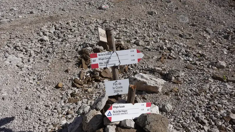
- Marker 3 – Pas de le Cirele 2684 m.
- Marker 4 – Passo di Ombrettola 2861 m.
- Marker 5 – The summit of Sasso Vernale.
Please zoom in for more details, and zoom out to see access roads and cities around.
Sasso Vernale route description
There is plenty of free place to park the car around the main road at Passo San Pellegrino. But if you want to shorten the walk a bit, you can enter the road to rifugio Albergo Miralago where you can leave the car on a paid parking. After that just keep walking in the direction of rifugio Fuciade.
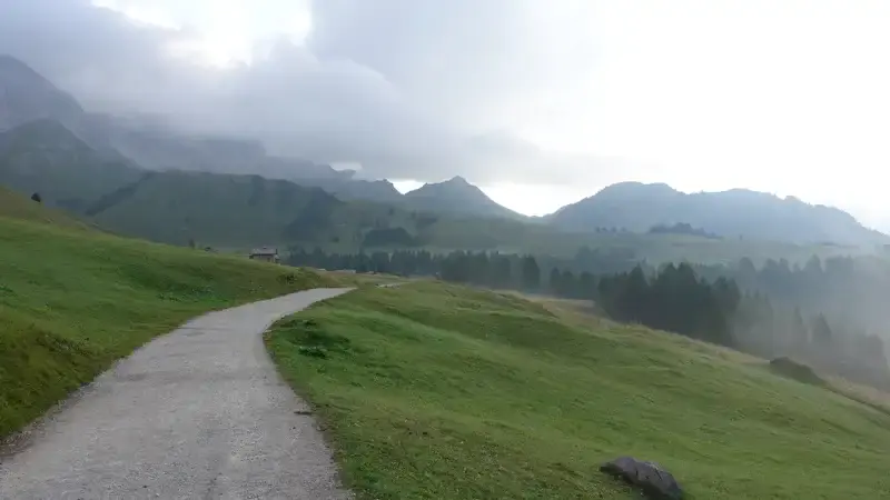
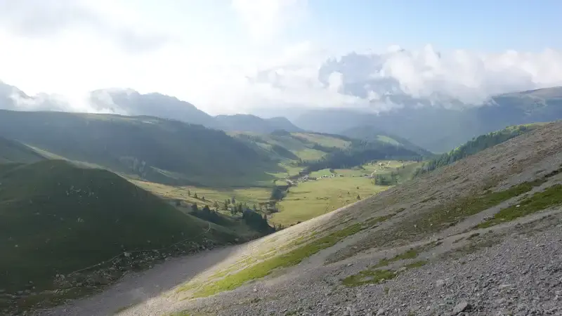
The photo below shows the area after you exit the forest, it was misty in the early morning, but this is an incredibly beautiful environment.
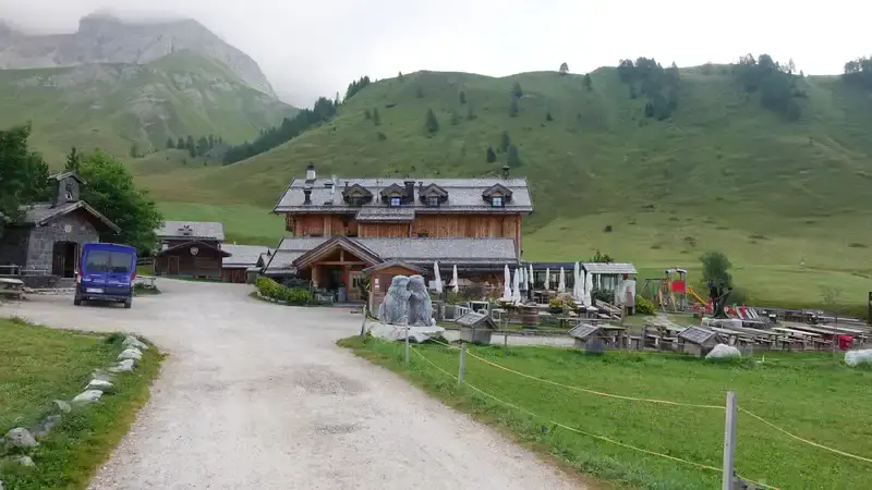
There was nobody around at Rifugio Fuciade in the early morning, see the picture below.
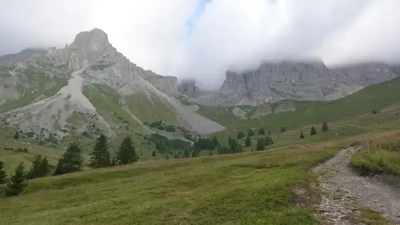
When you pass Rifugio Fuciade, the direction is up to the clouds in the middle of the photo below. This is the direction to Pas de le Cirele, and also to Contrin valley and Canazei area in the north.
Here, sweating is guaranteed, but see how it looks, worth every effort:
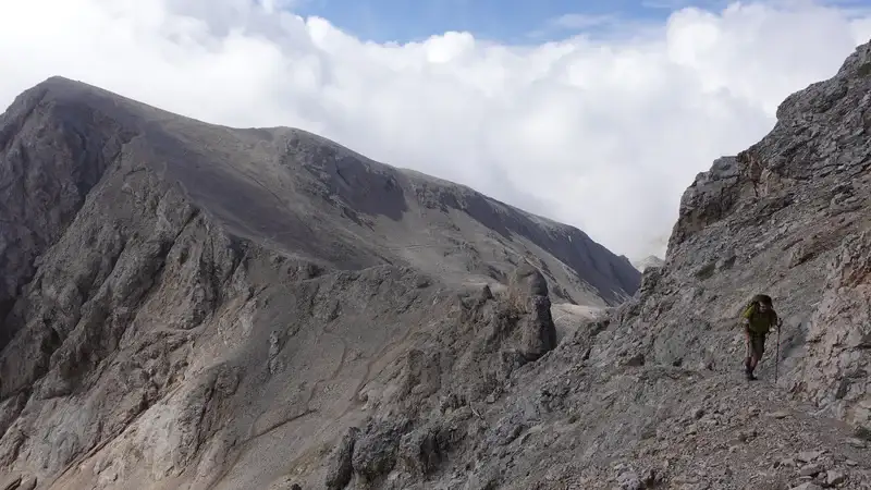
When you climb to more than 2300 meters of elevation, you arrive at a pass, and then you will have this in front of you, with the obvious route to follow:
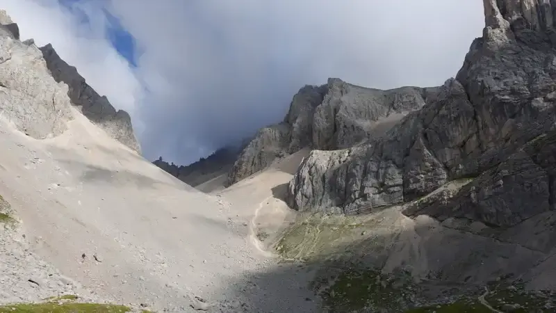
The route in the picture above goes to the right behind the rock, and this is the hardest part, steep and with scree all the time. But once you are over it, you get to a very pleasant plateau with great views, and this is the Pas de le Cirele:
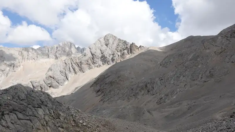
Below is the first view of the summit, this is from the Pas de le Cirele, and the route that goes in the direction of Passo di Ombrettola is visible.
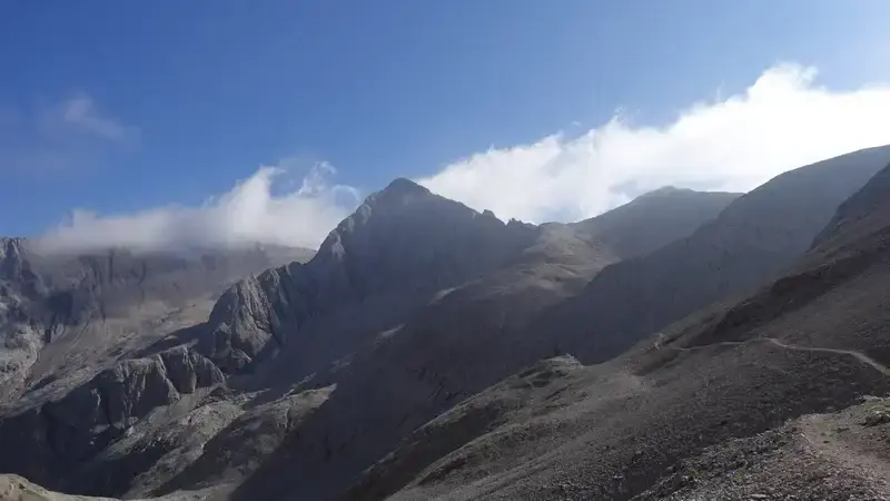
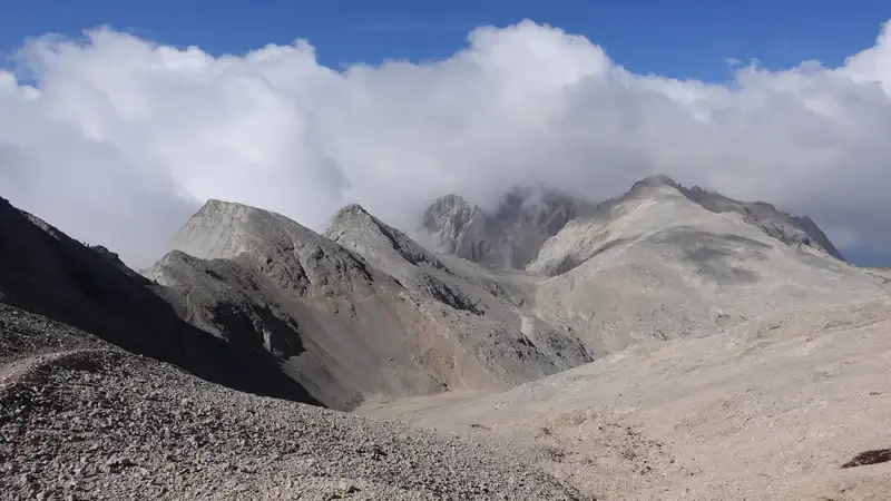
The route after that is quite easy, on a very high elevation and through a lunar-like landscape. Here is the view back to the Passo de le Cirelle when you get close to Passo Ombrettola, Cima dell’ Uomo (3010 m) is in the clouds behind. Note that this is a part of Alta Via 2 (AV2).
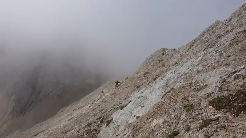
When you get to Passo Ombrettola, it is not obvious where to go, there are no signs for the summit. So descend a few meters to the east side and you will notice a tiny path that goes up to the final summit ridge. The picture below shows the ridge, it is sometimes with exposed passages, so be ready for that.
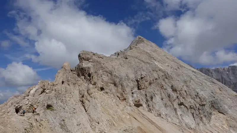
There are no cables or ropes, and no signs, just a few cairns. The summit is with a small cross, pleasant and wide, to stretch and enjoy the views if you have a great weather.
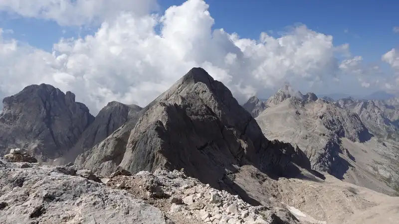
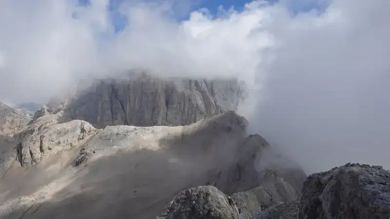
It was cloudy and Marmolada was not really visible, the picture below. The “small” peak in the middle is Cima Ombretta Orientale (3011 m).
Please see more in my video:
My tour to Sasso Vernale
I started from the main road at 7 am, and I was on the summit at 11:10 am. There were no people on the route at all. I truly enjoyed the walk. But it was quite cold higher up, in spite of all the sweating below Cirelle pass. I was happy to be in the sunny area on the pass.
At Pas de le Cirelle, I met a group of three rangers in uniforms, equipped with binoculars. They told me they were there to monitor wild animals.
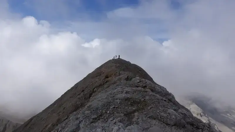
Apart from that, the only other person I met was a young man from Scotland, Felix, I found him resting at Passo Ombrettola. He was on the AV2 tour. He decided to join me to the summit so we walked together. Below you can see him in the photos.
Later at the summit, two Italians arrived, and this is why you can see three people on the summit in one of the photos above. The Italians left very soon, and a bit later we followed. A storm was supposed to come later in the afternoon, but it looked it was already there.
I made a rest at the Ombrettola pass and Felix left. There were a few other people coming and continuing to the summit, I was surprised because it looked hopeless in view of the clouds.
But the weather improved later, and it remained stable all the day. Below you can see my last view back, and now Marmolada is visible in the background.
When I was back at Rifugio Fuciade, hundreds of people were around, and the road back to Passo San Pellegrino was full of people walking in both directions.
Other Sasso Vernale climbing routes
The north-west side route
Sasso Vernale (Sas Vernel) can be climbed from the north side by starting from the village of Penia which is on the road to Fedaia pass. You can park at the lift station, but it is not free, and it can be full. Another option is to park on some places along the road as I did.
I am familiar with the complete route because I used it on my tour to Cima Ombretta Orientalle, one part on the way up, and another part on my descent round tour route. So I walked the entire route.
Note that you start at the elevation of 1550 meters, so this is quite lower compared to the Passo San Pellegrino route described above. You can see the route if you explore the map above.
From the parking, your direction is Rifugio Contrin, and from there you continue to Val de le Cirele. This route joins the route described previously at Passo di Ombrettola. Of course you can stay at Rifugio Contrin and make the tour much easier.
The east side route
The east side route is from Rifugio Onorio Falier, and there you get from Malga Ciapela. But I did not walk from that side so cannot provide first-hand information here.
If you know more, do share your knowledge in the comment box below.
Equipment for Sasso Vernale tour & accommodation
For this tour you do not need any special equipment. I used Mammut Sapuen GTX boots, a pair of trekking poles, and my Mammut Lithium 40 backpack. In the backpack, as usual, I had a rain poncho and rain pants, plus a rain jacket like the Mammut Crater Pro HS.
Regarding water, there is a source at the parking. Later, above Rifugio Fuciade there is a water stream, so you can refill if you have a water filter/purifier. Higher up the terrain is bone dry, no water around.
As for places to stay, there are plenty of options in the valleys around, please check the map:
Do you want to climb this mountain?
As you realize, I go solo, but I have been in this for 40 years already. This is a serious tour so if you want to do it and to play safe, which I warmly advise, get in touch with some experts and guides who can help you getting to the summit.
Final thoughts
In summary, climbing Sasso Vernale from Passo San Pellegrino was a demanding but rewarding experience.
The 4-5 hour ascent from the parking lot at 1918 meters to the 3058-meter summit offered stunning views and a mix of straightforward paths and challenging sections, especially the steep, scree-covered climb to Pas de le Cirele and the exposed final ridge.
With no signs marking the summit route and only a few cairns for guidance, the trek required focus and confidence, but the lunar-like plateau and panoramic summit views made every step worthwhile.
The solitude of the early morning ascent, interrupted only by a chance meeting with a Scottish hiker and two Italians at the summit, added to the raw beauty of the Dolomites.
The route’s high elevation, minimal equipment needs, and accessible starting point at Passo San Pellegrino make it a solid choice for experienced hikers seeking a less crowded alpine challenge.
Check the interactive map and video for a clearer sense of the terrain, and plan for variable weather to ensure a safe climb.
Thank you for reading. Let me know if you have questions or comments, there is a comment section below. You might want to read also my text about climbing Cima della Vezzana in Pale di San Martino group.
Please join us at our Facebook group Dolomites Visitors Hub.
Sasso Vernale (Sas Vernel) FAQs
What is the best time of year to climb Sasso Vernale from Passo San Pellegrino?
The optimal time to climb Sasso Vernale is late spring to early autumn, typically June to September. During these months, the weather in the Dolomites is generally stable, with milder temperatures and less snow on the trails.
July and August offer the warmest conditions, but early morning starts are recommended to avoid afternoon thunderstorms, which are common in the Alps. Always check local weather forecasts, as conditions can change rapidly at high elevations.
Are there any safety considerations for the exposed summit ridge of Sasso Vernale?
The final summit ridge of Sasso Vernale has exposed sections that require caution, especially for those without experience on rocky, unmarked terrain. While no technical climbing gear is needed, good balance and confidence on steep, loose scree are essential.
Hikers should wear sturdy boots with strong grip, carry trekking poles for stability, and avoid the ridge in wet or windy conditions to minimize the risk of slips or falls. Traveling with a partner can also enhance safety.
What wildlife might I encounter while hiking Sasso Vernale?
The Dolomites are home to diverse wildlife, and on the Sasso Vernale route, you might spot chamois, marmots, or ibex, particularly in the open alpine meadows above the tree line. Birds like golden eagles or alpine choughs are also common.
While encounters with larger animals like bears are rare in this area, it’s wise to stay alert, make noise to avoid surprising wildlife, and keep a safe distance if you spot any animals.
Can beginners attempt the Sasso Vernale hike from Passo San Pellegrino?
This hike is not ideal for complete beginners due to its steep sections, scree, and exposed summit ridge. It’s better suited for intermediate hikers with some experience in mountainous terrain. The 1140-meter elevation gain and 4-5 hour ascent demand decent fitness and navigation skills, as the summit route lacks clear signage.
Beginners should consider shorter, less technical trails in the Dolomites, like those around Rifugio Fuciade, before tackling Sasso Vernale. Here are a few routes in that area.
Leave a Reply