John Ball was one of the earliest foreign trailblazers in the Dolomites, arriving in 1857, years before Tuckett (1860) and Grohmann (1862). Yet despite his early lead, Ball failed to claim the ‘crown’ of the Queen of the Dolomites. This is the story of how, and why, he missed it.
When you go through table of contents of Ball’s book A guide to the Eastern Alps (1868), you realize that the highest mountain of the Dolomites, Marmolada, is not there. This is strange because some other mountains are there, like Pelmo, Civetta, Antelao.
But if you search the book carefully, you will realize that Marmolada is indeed described starting from page 477, buried in the dense text of this huge book, and the reason is both simple and slightly embarrassing:
When you read what he wrote there, you realize that Ball climbed Marmolada, but he chose the wrong peak, Punta Rocca, more about this below.
In case you are not into mountaineering history, John Ball is the first person ever to climb Monte Pelmo. The normal route to that mountain is the one he established on September 19, 1857. During this historic climb, he was accompanied by a local hunter and guide named Giovan Battista Giacìn (also recorded as Giovanni Battista Giacin).
About the Ball’s book
John Ball was both respected and occasionally cursed by 19th-century travelers. His writing style was incredibly dense, essentially a wall of text designed to pack as much geological, botanical, and topographical data into a portable pocket-sized book as possible.
Because he prioritized the route (the physical path from Campidello to Caprile) over the peak, the ascent of the Marmolada gets treated as a “detour” rather than a headline event, so it is in the section Trent to Caprile, by the Valley of the Avisio.
Why Marmolada is “buried”
It is about the Victorian aesthetic. At the time, guidebooks weren’t meant for skimming. They were meant to be studied over a candle in an inn. Ball expected his readers to read every word of a section before setting foot on the trail.
It is likely also about scientific humility. By “burying” his 1860 climb, he was being a good Victorian gentleman. Since he realized he hadn’t reached the absolute highest point, he likely felt it didn’t deserve a bold subtitle that might mislead a climber looking for the “true” summit.
Why Ball missed the highest Marmolada peak
In 1860, the Marmolada was still a mysterious, glacier-covered massif. From the vantage point Ball and his team had, the peak they climbed, Punta Rocca, appeared to be the highest point. It wasn’t until they actually stood on top of it that they realized they were looking across a gap at a slightly higher neighbor.
Here is the breakdown of why Ball missed the crown:
1. The optical illusion of the ridge
The Marmolada is not a single spire but a long ridge with several high points. When looking up from the Fedaia pass or the glaciers on the north side, Punta Rocca (3309 m) looks incredibly dominant.
The reality is that the true summit, Punta Penia (3343 m), is only 34 meters higher. Between the two lies a sharp drop and a jagged ridge. From the ground, it is almost impossible to tell which of the two is taller without professional surveying equipment.
2. The difficulty of the final gap
Even once Ball, Birkbeck, and Tairraz reached the summit of Punta Rocca and looked across at Punta Penia, they couldn’t simply hop over to it. The ridge connecting the two (the Cresta di West) is a technical and sharp arête.
In 1860, they were climbing with very primitive gear, heavy hemp ropes, and basic alpenstocks. They weren’t prepared for a technical ridge traverse at that altitude in what were likely deteriorating conditions.
3. Lack of reliable mapping
At the time, the official maps of the Austrian Empire (which controlled the area) were notoriously inaccurate regarding the high peaks of the Dolomites.
Ball was essentially a geographical explorer. He was mapping the mountain as he climbed it.
For many years after his climb, his ascent was still recorded in some circles as the “conquest of the Marmolada,” simply because nobody had yet proven Punta Penia was higher.
The final correction and first Marmolada Punta Penia climbs
Grohmann’s climb
It took another a few years for the mistake to be officially corrected on the ground. In 1864, the Austrian pioneer Paul Grohmann, the man who would become Ball’s great rival in Dolomite exploration, hired local guides and deliberately targeted the true highest point.
Grohmann reached Punta Penia on September 28, 1864, officially claiming the “Queen of the Dolomites” and proving that Ball had settled for the silver medal.
Grohmann was guided by Angelo Dimai, a legendary guide from Cortina d’Ampezzo, Fulgenzio Dimai, Angelo’s brother, and Pellegrino Pellegrini, a guide from Rocca Pietore. Pellegrini was a key figure; he had actually guided Grohmann to the lower Punta Rocca two years earlier, in 1862.
It appears that Ball wasn’t too bothered by the miss. For him, the Marmolada ascent was more about scientific observation and the thrill of the glacier than the ego of being at the absolute highest centimeter. I have read that he remained one of Grohmann’s biggest admirers.
Tuckett’s climb
The second climb was the group of Francis Fox Tuckett’s in 1865. He reached the summit of Punta Penia on June 2, 1865, less than a year after Grohmann. He was accompanied by a “dream team” of the most famous climbers and guides of the Victorian era.
His party included Edward North Buxton, Sir Thomas Fowell Buxton and the elite guides Michel Devouassoud from Chamonix, and Peter Michel from Grindelwald.
Note that at that time British climbers often brought their own “imported” guides from the Western Alps (Chamonix/Grindelwald) because they trusted their technical ice-climbing skills more than the local Dolomite hunters, who were better at rock but less experienced with large glaciers.
While Tuckett was second to the summit of Punta Penia, he eventually claimed a major “first” for himself on the Marmolada. In 1872, he made the first ascent of the west ridge (cresta ovest), which is now the most popular Via Ferrata route to the summit.
His guides for that 1872 climb were:
- Santo Siorpaes, a legendary local guide from Cortina d’Ampezzo. Siorpaes was arguably the most skilled climber born in the Dolomites during this era. He was the secret weapon for many British climbers, including Douglas Freshfield and Tuckett, because he possessed an intuitive understanding of Dolomite limestone that the glacier-focused Swiss guides often lacked.
- Christian Lauener, an elite Swiss guide from Lauterbrunnen. Tuckett often traveled with a Swiss or French guide for consistency and high-altitude ice experience, and Lauener was a frequent partner for these expeditions.
Note that Ball, Tuckett, Grohmann, and Freshfield cycled through the same few inns, often using the same guides to “correct” each other’s mistakes.
Ball’s original Marmolada description
Here is the part from the book where he describes the Marmolada tour on page 478:
The ascent of the Marmolata is an expedition which will be attractive to all practised mountaineers who may visit this district.
Although the writer, in company with Mr. J. Birkbeck and Victor Tairraz of Chamouni, arrived within a few feet of the summit of the second peak of the mountain in 1860, the weather was so utterly unfavourable that his acquaintance with the mountain is mainly derived from the narratives of Dr. Grohmann, who reached the same peak in 1862, and made the first ascent of the highest summit in 1864, and from notes kindly communicated by Mr. Tuckett, who effected the second ascent in 1865.
The name Vedretta Marmolata, often given to the mountain because its northern declivity is covered with névé, or glacier, should be rejected. The description given by Mr. Churchill, who likens the form of the mountain to a wooden case for stationery, vertical on one side, and sloping at a high angle on the other, conveys very well the impression gained when the mountain is viewed in profile from the W. or E. side.
To speak more accurately, the mountain may be described as a ridge extending from E. to W. with two central peaks, divided by a comparatively slight depression, and flanked by two attendant summits, one on the E. the other on the W. side. On the S. side the ridge falls in a range of precipices, in great part nearly vertical, and averaging about 3000 ft. in height.
On the N. side four massive buttresses project from the main mass, and between these three tongues of glacier, fed by the continuous slope of névé that covers the range on this side, descend towards the basin of Fedaya.
Viewing the mountain from the N. side-the most favourable point being the Forcella di Padon (Rte. I), the eastern flanking peak, called Saranta (9947′), is seen to the l.; to the Marmolata di Rocca, or second peak, which, according to the ‘ Kataster measurement, is 402 ft. lower than the W. peak.
Separated from the latter by a well marked depression in the ridge, is the westernmost summit near Penia, called by Dr. Grohmann, Vernel; but the writer doubts whether that name is known in the Val di Fassa.
The most direct and easiest course for the ascent seems to be that taken by Mr. Tuckett. Approaching the base of the peak by the central tongue of glacier, which is that nearest to the Fedaya châlets, he ascended thus until the rock-buttress on his rt. hand disappeared beneath the névé, and then bore to the rt. until he reached the lower part of the trough or couloir which divides the two main peaks.
Finding the rocks on his rt. hand to be unexpectedly easy, he climbed up them, and so reached the topmost calotte of névé, when the actual summit was easily attained.
Under favourable circumstances, the expedition seems to be free from all serious difficulty, but it would be unwise to attempt the ascent without at least one guide well used to ice-work, a qualification not possessed by any of the natives of Fassa.
The ‘Kataster’ measurement of the highest peak is 11466 ft., while a careful barometric determination by Dr. Grohmann gives only 11045 ft. As the Kataster’ measurements do not inspire complete confidence, and a single barometric measurement is subject to many chances of error, it is allowable to infer that the height of this crowning summit of the Fassa Alps is not yet satisfactorily determined.
Dr. Grohmann is persuaded that one of the Primiero summits, doubtless the Cimon della Pala, nearly equals, if it do not actually exceed, the height of the Marmolata. This question also remains for further investigation.
Just to know, the height of Marmolada Punta Penia is 3343 m (10968 ft), so Grohmann’s measurement was much better than the mentioned Kataster’s.
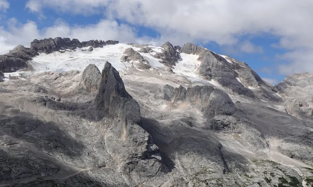
Ball is right regarding the best overview of the Marmolada massif. The top picture above is indeed from the Padon area which he mentioned. I took it from my tour to Ferrata Trincee.
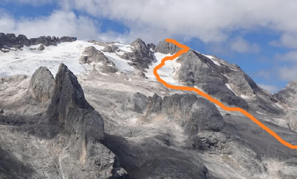
The photo below shows the current normal route to Marmolada Punta Penia which Grohmann’s team followed. This is also the route that I followed in my solo tour to Marmolada.
In a way, Ball’s failed Marmolada ascent makes the story even better. It shows how deceptive mountains can be, even for the best explorers of the era, and how easily a few meters of height can hide behind a ridge of rock and ice.
And it also explains perfectly why Marmolada feels like an afterthought in his book: Ball did not want to advertise a summit he knew was not the true one.
Thank you for reading. Please use the comment section below if you have questions or comments.
Leave a Reply