Lacedelli and Grohmann climbed Tofana di Mezzo the hard way from the south side, but nowadays there is a lesser-known walk-up route to the summit. So why did they avoid it?
Lacedelli and Grohmann ascent of Tofana di Mezzo
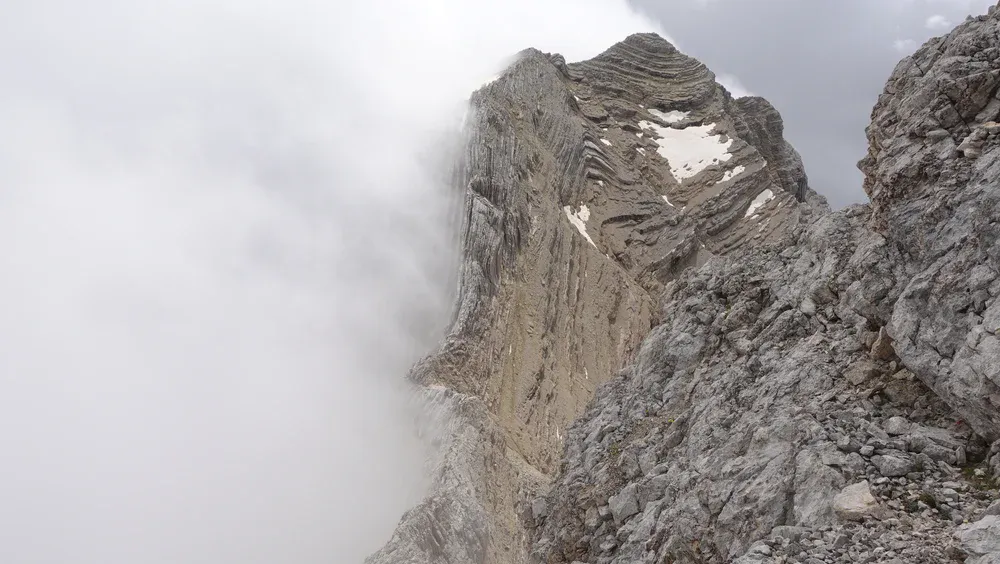
On August 29, 1863, Grohmann climbed the mountain along with guide Francesco Lacedelli. They approached it from the south face/southeast flank. This is a vertical, tiered rock climb. It was technically hard because they were essentially free-climbing limestone chimneys and steep ledges without a path.
This is the area where several hard ferratas now lead to the summit. This was true exploration. They had to navigate the complex, crumbling terrain of the massive southern amphitheater. Unlike the other peaks, Mezzo required navigating high-altitude chimneys and steep, unstable rock steps.
Even today, if you strip away the steel cables of the modern Ferrata Gianni Aglio, the exposed ridges and the final summit “tower” are technically more demanding than the trekking terrain found on the other two Tofanas.
The zoomable map below shows some details that are discussed here in the text. Marker 1 is the place where Rifugio Giussani now stands. Marker 4 is the summit of Tofana di Mezzo. The remaining markers are mentioned further in the text.
Grohmann’s own description of the Tofana di Mezzo climb
These are lines from his book Wanderungen in den Dolomiten (1877), translated from German:
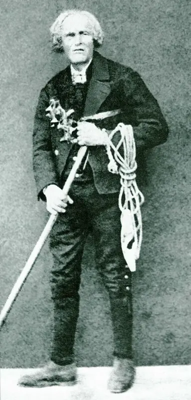
When I began climbing the high peaks of Ampezzo in the summer of 1863, my first guide was Francesco Lacedelli da Meleres. He wasn’t the best guide I could have found simply because it would have been difficult to find another at that time, but because of his truly outstanding qualities: strength and endurance, agility, a courage that didn’t shy away from any obstacle, temperance, the ability to find his way anywhere, and finally—ambition!
The man didn’t go for the meager profit; he was, and still is, among the wealthy farmers of Ampezzo—he went largely out of ambition. This robust man had only one flaw: his age. When I met him, he was already well over sixty. This circumstance, however, only had an impact on speed, a disadvantage which I, quite rightly, did not overestimate.
One must not forget that at that time I knew neither Fulgentio Dimaj, nor Alessandro Lacedelli, nor Angelo Pizzo, nor Santo Siorpaes! With the exception of the excellent Angelo Pizzo, who unfortunately passed away, they were then foresters, chamois hunters, and farmers—but they had no guides. All of them, without exception, made their first journeys as guides with me and, I think I may say, progressed with their greater aims and goals.
They all proved themselves, are without exception good people, reliable guides, and for the most part, excellent people.
I had been a foreman. But that shouldn’t prevent me from especially remembering the man here who first and foremost supported me, and who was always and at all times ready for any attempt. When I told Francesco (Geccho for short) of my wish to climb the Tofana, he was immediately ready to accompany me, and the departure was set for the next morning.
Since Geccho had also never reached the summit, we took the direction that, in his opinion, would lead us most safely to our goal, that is, the same direction as if we were going to Falzarego, leaving Monte Crepa to our left, to Pocol, etc.
After about 1 hour and 45 minutes from Cortina, we entered a meadow called Ciamp Zoppè. Here I first got an idea of what kind of climb lay ahead of us, and I confess that I was anything but pleased when Geccho presented the Tofana to me.
It wasn’t the walls that bothered me, but on the contrary, what stretched up between them: an immeasurably long scree slope. Anyone who has ever had to climb such steep, long scree slopes will understand my delight at such a sight.
The ascent that followed was long and not easy; finally, we approached a huge boulder that divided the scree into two arms.
Here, Geccho challenged me to decide which of the two Tofana peaks, T. di R. or T. di Mezzo, I wished to climb. You can laugh easily, dear reader, at this question!
I had explained that I wanted to reach the highest peak, and the only slight difficulty was that none of us knew where the culmination point was. The cadastral survey of Tyrol was probably underway at the time, but its results were not yet known to me, and since such questions cannot be answered with certainty from below, we had postponed the search for a solution.
However, our current position was not very suitable for solving the problem. I decided on the Tofana to the right and fortunately achieved my desired goal. First, we had to climb the right arm of the Schütt (the steepest section) to reach the Tofana ridge.
An almost magically wild view of the walls towards Travenanzes surprised us here. But how to proceed? The rocks seemed inaccessible! But Geccho skillfully climbed around a corner, and the rest of the way lay before us.
First, we traversed a narrow strip slightly downwards across the wall, then suddenly and exceptionally steeply upwards for just a short distance, and we reached the snowfield which, as mentioned above, stretches out on the traverse side between the two Tofana peaks.
Crossing this snowfield, we headed directly onto the ridge leading up to the summit and along it, reaching the highest point without further difficulty. By then, however, it had grown late.
I hadn’t anticipated that the route would prove so lengthy, and we had therefore not left Cortina very early; moreover, Geccho had climbed rather cautiously, so it was half past two when we reached the summit! An enormous waste of time; but what did I care, for I had achieved my goal, having climbed the first high peak of Ampezzo!
The return journey had to be fun, down over the scree slopes, and accomplished in an incredibly short time. The summit offers enough space for a number of people and presents a magnificent panoramic view. It was my first time in this mountain world, and I was content, without further study, to take in the magnificent scene.
A few comments here:
• He describes Lacedelli as “ambitious”. I think this is projection; such a label best describes Grohmann himself.
Ambitious for what, to become a world famous climber? Lacedelli was too old for such ambitions. He simply had a genuine passion for the heights. Did you know that he was the first to climb Croda Marcora (3154 m) on September 2, 1864, alone, at the age of 68?
Also, as a city boy from an imperial capital, Grohmann did not understand simple things about peasant life. Perhaps the “wealthy” farmer had land and cows, but those precious things had to be preserved. One needs cash for daily life and to pay taxes. But clearly Lacedelli would go to the mountains even without money.
On the other hand, there is a sentence in Ball’s book, p. 505: “3 fl. a day, said to be the rate established by Dr. Grohmann; very moderate pay for arduous ascents, but too much for mere ordinary excursions.” So Grohmann was not really too generous, but that extra money was needed.
But based on what I am able to find online, Lacedelli was also a clockmaker, so he was able to earn in that way as well. Being a clockmaker required a level of education, a sign of a middle-class status in a rural mountain society. This brings us to the following:
• Grohmann writes he was “a foreman”. I find this statement ridiculous, he was obviously completely dependent on the old man.
Grohmann was a classic 19th-century academic explorer. Even though he relied entirely on the Lacedellis’ physical strength and knowledge of the terrain, he viewed himself as the “project manager” or “director” of the climb.
He was the one who owned the barometer. To him, the locals were the engine but he was the navigator ensuring they were actually making a scientific contribution. By calling himself the foreman, Grohmann was asserting that the intellectual achievement of the climb belonged to him, while the physical labor was the guides’.
Essentially, Grohmann provided the ego and the scientific tools, but the old man provided the raw power and survival skills. It’s the classic mountaineering irony: the person hiring the guide thinks he is the leader, but the guide is actually the one keeping the leader alive.
• Grohmann writes respectfully about his guides in general, but he describes those hours to the summit as a “waste of time”.
For the record, his guide Lacedelli was 67 years old. Grohmann himself was 25. So Lacedelli was considered very old at that time, the average life expectancy was much lower then.
So yes, following a 67-year-old man on an incredibly harsh and dangerous, never-climbed mountain might have looked slow and boring to an impatient young “foreman”.
But hey, how about climbing alone and carrying your rope and gear yourself, and saving time and money? Just as Lacedelli did on Croda Marcora. No, Grohmann was not a foreman built of such a material. If he did any minor unrecorded solo hikes, they weren’t historically significant enough to be noted in the literature.
One can question his motives and character, but to be fair, this doesn’t diminish his achievements. He was a driving force in mapping, documenting, and opening the Dolomites to wider mountaineering through his writing and advocacy.
There are a few reasons why he likely never did a major solo climb:
1. The era of the “gentleman alpinist”
In the 1860s, the social structure of mountaineering was very rigid. Figures like Grohmann were wealthy urbanites (he was from Vienna) who hired local “peasant” guides (huntsmen or farmers) for their physical strength and local knowledge.
Climbing alone would have been seen as eccentric, if not borderline suicidal, given the lack of maps and established routes.
2. Scientific logistics
Grohmann’s mission was mapping and measuring. He carried a heavy mercury barometer to calculate the height of peaks. Carrying delicate scientific instruments while navigating unclimbed limestone faces in the Dolomites is a two-or-three-person job.
3. Safety and technology
The equipment of the time, heavy hemp ropes, leather boots with nails, and primitive wooden axes, wasn’t designed for soloing. Grohmann was a methodical, disciplined climber, not a daredevil. He viewed guides as essential “tools” of the trade, much like his barometer.
Confusing descriptions in Ball’s book
On page 505 in the book A guide to the Eastern Alps by John Ball, 1868, there is the following statement:
Dr. Grohmann, having gained the crest of the ridge connecting the SW summit (Rozes) with the highest (Mezzo), turned to the rt. and followed the ridge chiefly by the side overlooking Val Travernanze (Travenanzes), finally attaining the summit by a rather steep ice-slope.
Now, what is “the crest of the ridge”? The only area connecting Rozes and Mezzo is Forcella Fontana Negra (2616 m), where the Giussani hut now stands. But nobody would describe this area as a crest. Yet Ball was a true alpinist and the first person ever to climb Monte Pelmo, so he knew what he was talking about.
Grohmann used the same “crest” (Forcella Fontana Negra) one year later when he climbed Tofana di Rozes.
Note also that Ball writes about an ice slope on Tofana di Mezzo. Clearly, the conditions were very different then: there is no ice on Tofana di Mezzo now, but see more below.
But which crest is this? I have no answers to these questions.
The mentioned Forcella Fontana Negra is the pass between Rozes (right) and Mezzo (middle) peaks shown below, view from my tour to Bivacco della Pace:
Alternative walk-up west side route
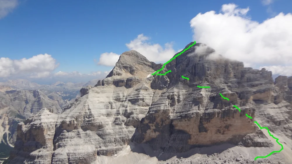
Nowadays, people who do not take the lift and want to climb Tofana di Mezzo usually do attractive ferratas from the south side. But perhaps not many people are aware of a hidden walk-up route that starts from Rifugio Giussani.
From there, there is a barely visible route that goes north to Forcella del Valon (marker 2 on the map). I walked it partly and can confirm that it is very steep and very hard, with lots of soft scree. It leads into the hidden cirque with a lake (marker 3) between Dentro and Mezzo, as you can see below. You can see the route on the map above.
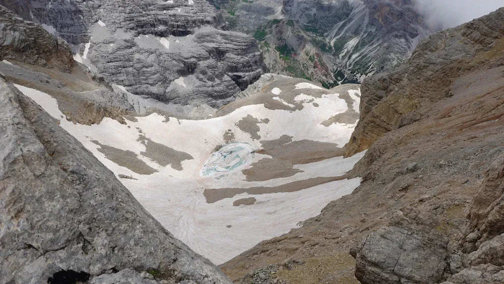
This photo was taken from Forcella Tofana. The lake is at around 2950 meters of elevation and is frozen even in late July, as you can see from my photo. Below you can see the mentioned walk-up route in the snow on the left:

My guess is that nowadays this is used as a descent route by people who climb Tofana di Mezzo via ferratas on the south side.
The following photo below is my view from Tofana di Rozes, and I added the green line that roughly shows the walk-up route. The broken-line part indicates the fact that the route is not visible in the photo, as it goes behind the rock; there is a passage over the mentioned Forcella del Valon.
So, why didn’t Grohmann take this simplest west side ascent?
I could not find an answer, and here is my guess about the possible reasons.
In my recent post, I showed a painting of Monte Pelmo with its upper cirque filled with a glacier. This is from a book published in 1864, and the authors were in the area when Grohmann climbed.
In fact, if you follow the link above, you will read that Grohmann himself writes in his book that Pelmo was under a glacier. The same is true of Ball, the first person who climbed Pelmo: in his book he also writes about the glacier. This Pelmo glacier is at nearly the same elevation as the lake area in the previous pictures.
My guess is that this high-elevation bowl/cirque below Tofana di Mezzo was also completely filled with ice. This would make access over Forcella del Valon far more difficult.
Grohmann climbed with a local person, Francesco Lacedelli. He almost certainly knew the area where the frozen lake now is, and advised Grohmann to access the mountain from the south, which nowadays looks far more difficult. This makes no sense.
If there was ice, how thick was it?
Here again, I have my guess based on some indirect evidence. In my text about the cave below Marmolada summit, it is described that it was carved out in 1875 at the level of the glacier. Nowadays, this cave is on the cliffs 80 meters above the glacier.
So the glacier melted over one and a half centuries, and its thickness was reduced by 80 vertical meters.
Therefore, even if the glacier below Tofana di Mezzo was 80 meters thick, it would have completely vanished by our time. Note again that the elevation is similar to the mentioned Marmolada area.
On the other hand, such a huge mass would have created a major physical obstacle hanging above the steep slopes and cliffs behind Forcella del Valon.
You have seen above that Grohmann wanted to be on his first summit no matter what. No doubt he would have chosen an easier way if it had been available. This logic was used in his other two Tofana climbs:
Grohmann climbing Tofana di Rozes
This was on August 29, 1864, and it is widely assumed that Grohmann was the first to climb this mountain together with his three Italian guides. But there are claims in various places that locals climbed it several times years before. You can see it on page 505 in Ball’s book.
They bypassed the terrifying 1000-meter south face (which wouldn’t be climbed for decades), above Rifugio Angelo Dibona, which was not there at the time.
Instead, they attacked the mountain from the back (the northwest). This is now the normal walk-up route to the summit, which I followed myself. It passes Rifugio Giussani.
Here are his original lines translated from German:
Since the route to this high peak largely coincides with the previous one (Tofana di Mezzo), I will include its ascent here. From Cortina, we again go over the Boite and to Meleres, Pocol, and the meadow Ciamp Zoppè, where one can see the large depression between the two peaks, filled with an immense flow of scree and sand.
The path continues for some time from the valley floor, leading upwards along a green trail until we reach the end of the vegetation and the beginning of those sad, yet magnificent, slopes. For those who perhaps only wanted to commit the image of destruction to memory and do not wish to go any further from here, it should be noted that here, on the edge of the desert, a quite worthwhile panorama of the Ampezzo mountains unfolds.
We left the large scree slope, which we climbed last year, to our right and entered the one on the left. It is easier to traverse and leads, after about half an hour, into a kind of high cirque and from there directly up to the Forcella della Fontana Negra, a pass to Travernanzes, which descends near the shepherd’s hut in the latter valley. It is used only by chamois hunters.
Now we stood on the narrow saddle, with Travernanzes far below us, the formidable walls of the Tofana to our right, and Monte dei Cavalli towards Fannes in front of us. From Ampezzo to here, you can expect a journey of 2.5 to 3 hours.
Our destination is still visible high above us to the left. Snow-creased slopes rise towards it, but the incline is not very steep. We first aim to reach the crest of the mountain, about 30 meters, then continue uphill for another half hour or so along the broad ridge, and the summit is reached.
It was livelier this time than over on the other peak, because Angelo Dimaj and Santo Siorpaes had voluntarily joined Geccho and me to learn the route. Consequently, to commemorate the numerous visitors, one more cairn was erected than on our opposite peak.
From this description you can see again which access route they used to Mezzo, and also realize that Forcella della Fontana Negra was clear of snow. So the description by Ball given above remains confusing.
Note: he uses Travernanzes instead of Travenanzes, as it is called now.
Grohmann climbing Tofana di Dentro
Grohmann climbed it guided by the local man Angelo Dimaj on August 27, 1865. This was again the first ever recorded climb of the mountain.
They ascended it from the northeast by following a straightforward ridge climb, which is now the normal walk-up route that I also used on my tour.
So you see the point: for the other two peaks in the Tofana group he used the easiest walk-up routes. Then why not also for Tofana di Mezzo?
Based on what is presented above, I think this was because there was a huge obstacle on the way up: a glacier. So far this is all pure guesswork but keep reading.
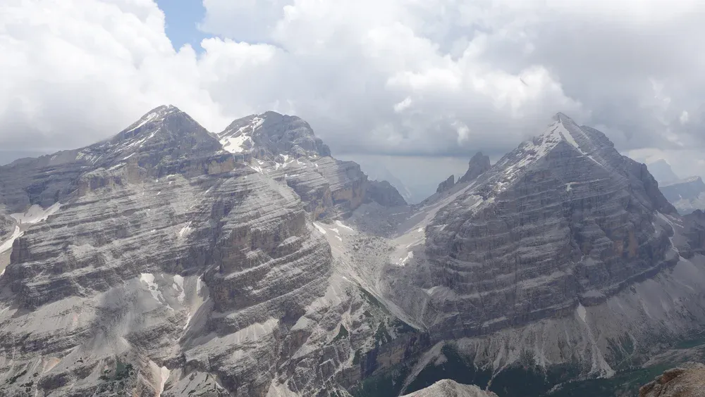
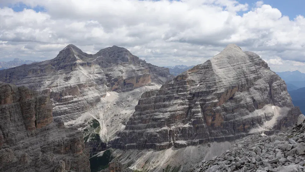
All three Tofanas are shown in my photo below from my tour to Cima Fanes Sud. Forcella Tofana is between Dentro (left) and Mezzo. Tofana di Rozes is completely on the right.
Grohmann knew yet another new route to Tofana di Mezzo
As you have seen, Grohmann climbed Tofana di Dentro (he uses the name Tofana di Fuori) two years later. Here is an interesting part from his description, again translated from German, and from the same book:
A wild, rocky world surrounds us here. Before us are the steep drops of the Tofana di Mezzo, and to the right, those of the Tofana di Fuori. Between the two, a narrow cleft leads up to the highest ridge of the range. This ridge provides access to the summit of the highest Tofana via the so-called “new route,” while the Tofana di Fuori has not yet been climbed this way. An attempt to do so should be successful.
Those who have already climbed the highest peaks now follow the same route as us, up to the Forcella della Valle, and for a little further.
From the Forcella, we initially head straight towards the slopes of the Tofana, then turn right and follow them until, at a layer of hard-frozen snow rising up the walls, we spot an opportunity to access the rocks at a favorable point. Steep but safe, we now ascend these rocks to reach the ridge.
Before reaching it, we encounter the only point on the entire route that might deter some, but it is of no significance to experienced mountaineers. Once on the ridge, the real difficulties are overcome. We maintain our altitude throughout, ultimately following the snowfield that leads to the summit. The route is longer than it appears from below.
Just to clarify: Forcella della Valle is what is now called Forcella di Ra Vales.
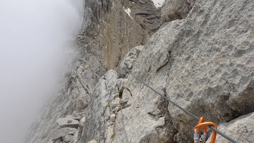
So at the time of writing his book in 1877, there was a new route established to Forcella Tofana and then to Tofana di Mezzo. This is the ridge where Ferrata Lamon now runs. Access to it was from the plateau where the Ra Vales lift station now stands.
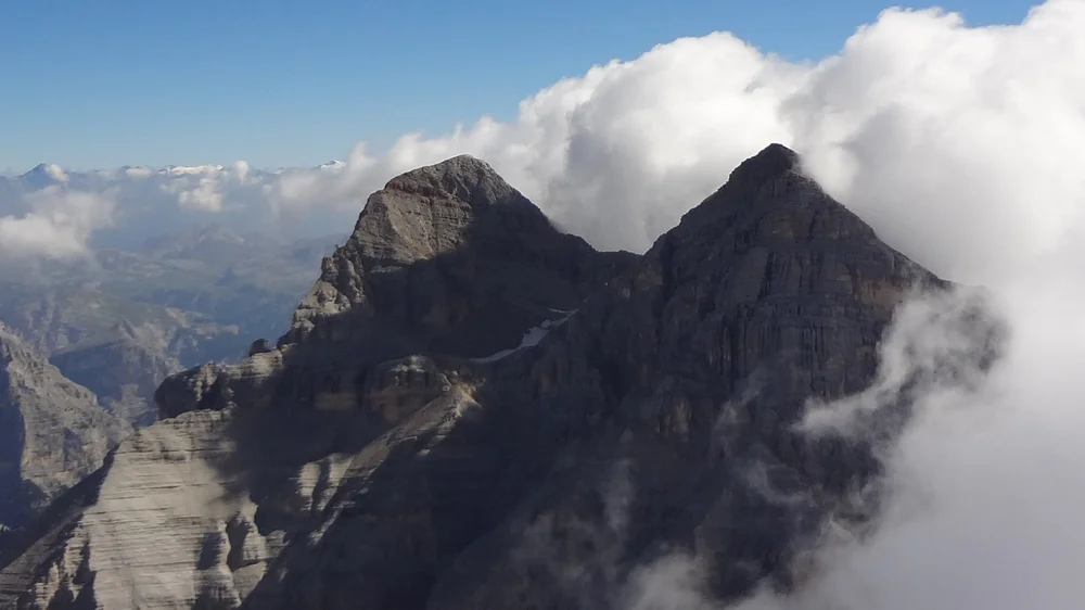
The photo below shows a close view of this sharp ridge and its lowest point at 3084 m. The access is from the clouds side (i.e., east), and it is incredibly hard.
On page 98, in a footnote, he gives an extra detail about that new route:
The famous English mountaineer Tuckett climbed the Tofana via this route in four hours.
So, from his lines we also learn that nobody climbed Tofana di Dentro from Forcella Tofana. Nowadays, Ferrata Lamon goes from one peak to another.
This “new” route does not exist any longer; you will not find it on any modern map. I think this is simply because it is too hard. And yet, in spite of its obvious difficulty, they established this as a new route and not from the west side. So again: why?
Why didn’t they look for a better way down from Tofana di Mezzo?
You might wonder why, once they were at the summit, they didn’t look toward Forcella Tofana and the lake and think, “Hey, that looks like an easier walk down.” From the summit, the entire route down to the lake area is clearly visible. I know because I was there.
This is what my glacier hypothesis might explain: if they stood at the summit and looked north toward the Forcella and what the frozen lake area now is, they wouldn’t have seen an easy path. They would have seen a sheer drop-off onto a steep, broken glacier.
In 1863, with no crampons and only a wooden alpenstock, a steep ice slope was a “no-go” zone for descent.
To Grohmann and Lacedelli, the hard rock they had just climbed was actually the only safe option, because at least the rock was dry and familiar. As you have seen above, Grohmann writes: “The return journey had to be fun down over the scree slopes”.
Well, if you have ever seen the south and southeast side of Tofana di Mezzo, you will be perplexed by his words.
Descent here can be anything but fun. To get to the scree, you have more than half a kilometer of vertical cliffs. Even with ferrata cables that are in place now, I do not think that many people descend that way. But it appears they did not have any other option then.
Could I be wrong with my hypothesis?
Grohmann’s and Lacedelli’s behavior indicates that my hypothesis may be correct. Imagine: a previously unclimbed mountain. Who would climb cliffs that are more than half a kilometer high if there is a walk-up back route? Who would descend such cliffs instead of simply walking back?
On page 98 Grohmann writes:
The ascent we had taken is definitely not recommended to any successors, because it is not for everyone to climb for hours over such scree slopes. Fortunately, in the meantime, the slope angles of the Tofana haven’t changed, but the guides’ opinions have. Our route is—and I say with full justification—dismissed as a laborious and poor detour.
So you see, he writes about scree slopes but not about vertical and deadly cliffs. And as you have seen earlier, even when writing about descent, it is again only about scree slopes. Very puzzling.
So, although it sounds hard to believe, perhaps they did not use that west side route simply because it was not known to anybody. This is in spite of Ball’s claims that locals climbed Tofana di Rozes several times before Grohmann arrived, and they would consequently have had a clear overview of Tofana di Mezzo’s west-side area, just as I had and showed in my photo above.
Austrian old military maps show Tofana glaciers
As a last resort, I asked my friend Daniele Fontana. We met on Antelao, as you may read in the text there. He is from the area, a mountaineer, and also a geologist by profession. To my delight, he sent me a link to an old Austrian military map. It is shown below, and you can see all three Tofanas.
The summit of Tofana II (Mezzo) is not completely clear on the map. There are two numbers at different positions, and it appears that the true summit is given the wrong (smaller) elevation, so perhaps this was a mistake.
What you clearly see are glaciers around Tofana II. The coordinates of the westernmost Tofana II glacier in the picture (it is in the middle of the picture below) match the coordinates of the lake in the interactive map I gave above. You can confirm this if you follow the link given above, as it shows the coordinates as you move the cursor over it.
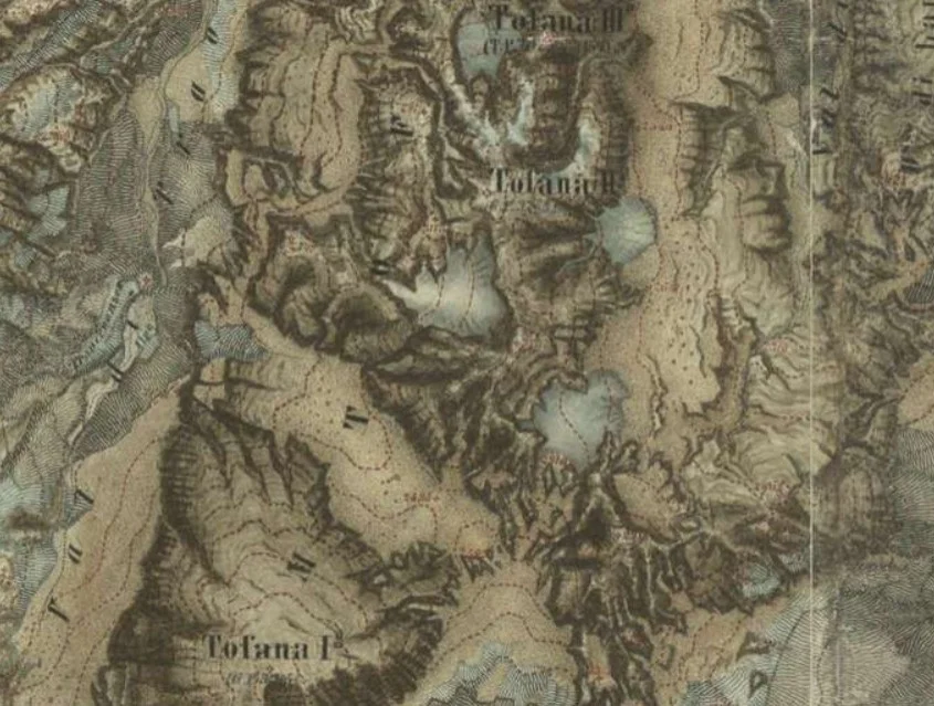
The other two larger Tofana II glaciers are marked in my interactive map as markers 5 and 6.
Looks good for my hypothesis, right? But wait…
There is more
There are a couple of paragraphs in Grohmann’s book that may ruin my hypothesis again. On page 94 in his book, he writes this:
Tofana di Mezzo and Tofana di Fuori lie close together between Travernanzes and the valley Le Valle (which again divides the Tofana group into two parts). The measurement of the latter still originates from the cadastral records. The former, the highest peak, lies south of the latter, between the two ice masses in Le Valle and Travernanzes, clearly marked in the map.
As is well known, the firn world has only sparse representatives in the Dolomites. The Tofana has a few of them, although they are only of small geographical extent. I know five of them from personal observation. One in the background of Le Valle at the foot of the Tofana di Mezzo, two others at the foot and on the slopes of the Tofana di Fuori, then one on the ridge and near this summit, and one between this summit and the highest peak on the Travernanzes side.
It seems obvious that the last line in this paragraph describes the area where the lake now is. So, at the time of writing the book 14 years later, in 1877, he was aware of the lake area and he knew about firn, not about ice.
He did climb Tofana di Rozes in the meantime, and from there he had possibly seen the same view that was in front of me when I was on the summit, perhaps with better weather conditions than I had:
The lake area is partly visible, though clouds create shadow here. Grohmann had definitely seen more white stuff there. But it is certain that he never walked into that back area behind the summit.
Firn or glacier?
Here is a revealing paragraph from Grohmann’s book about his climb of Tofana di Dentro:
During the cadastral survey of Tyrol, a pole was to be carried up. The porters, however, did not quite reach the summit and deposited their load a considerable distance below it. Thus, the ascent also had the allure of novelty. Certainly not the main thing in mountaineering, but a factor that has often given the impetus to the most beautiful Alpine journeys.
As you see, there were surveys before his climb, and people involved were somewhere below the summit. It is logical to assume that such surveys were taking place everywhere around at lower elevations. The Austrian map with glaciers is the result of this.
On the other hand, Grohmann was never close to the discussed northwest lake area. His claims about firn were probably based on remote observations. With surveyors this is less likely, so I would rather rely on their map and accept glaciers as a fact.
Anyhow, I will stop here. If you think I missed something or messed things up, do let me know in the comments below.
Just to add that they climbed Antelao just three weeks later in a group of four led by Ossi. Thank you for reading.
Leave a Reply