I climbed Cima Ombretta Orientale from the main road at Penia village. I began by walking toward Rifugio Contrin and Bivacco Marco Dal Bianco, and then completed a round descent that utilized a via ferrata section, before walking past the Rifugio and back to the parking spot.
Cima Ombretta Orientale can be climbed from several different valleys: from Alba-Penia (Canazei), Malga Ciapela, Passo San Pellegrino, and San Giovanni di Fassa.
Time estimate: Plan for approximately five hours for the ascent starting from the Canazei direction.
Equipment:
- Standard route: No technical climbing equipment is required to reach the summit.
- Round tour: If you opt for the Ferrata Ombretta-Vernale as part of a round tour, you must have all necessary via ferrata equipment with you.
Cima Ombretta Orientale coordinates and numbers
- Elevation: 3011 m (9879 ft).
- Nearest places for supplies: Canazei, Alba, Penia.
- Mountain group: Marmolada, Dolomites, Italian Alps.
- Summit coordinates: 46.4243253 N, 11.8464778 E.
- Route difficulty: walk up and easy ferrata.
- Elevation difference from the car parking: 1518 m (4980 ft).
- Parking coordinates: 46.4585778 N, 11.7873189 E.
- Time needed from the parking to the summit: 5 hours or so.
- Shelters: Rifugio Contrin, Bivacco Marco Dal Bianco.
- Useful map: Val di Fassa e Dolomiti Fassane. Tabacco 06, 1:25000.
Access roads and map
I have created the interactive and zoomable map below for the route which I walked myself. The markers meaning is as follows:
- Marker 1: Car parking area.
- Marker 2: Rifugio Contrin.
- Marker 3: Pas de Ombretta.
- Marker 4: Bivacco Marco Dal Bianco.
- Marker 5: The summit of Cima Ombretta.
- Marker 6: Ferrata Ombretta-Vernale.
If you zoom in, you can see lots of details regarding the route. Zoom out to see access roads to the area.
Route description
From parking to Ombretta pass
There is a large, paid parking lot at the lift station situated between Alba and Penia. However, this is a busy hub with lift lines servicing both sides of the valley, and the lot can fill up quickly.
If it is full, don’t worry, simply continue driving along the main road toward Fedaia. Just above the village of Penia, you will certainly find free roadside parking in one of the many designated spots. From there, walk back toward the lift station, as the trailhead begins there (see the map above for details).
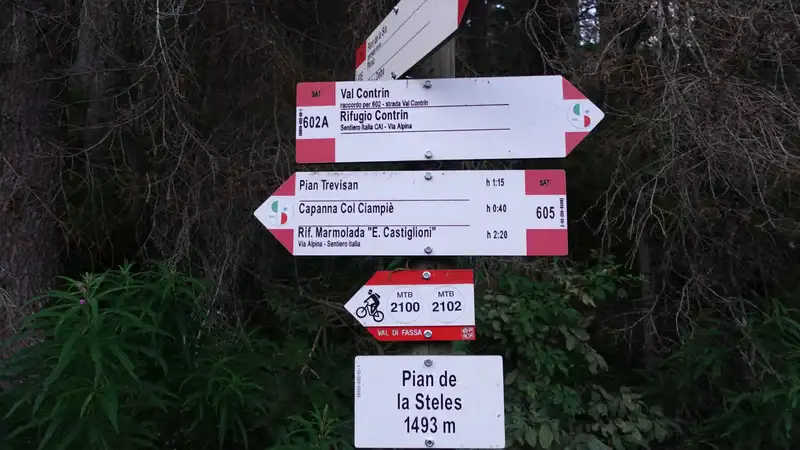
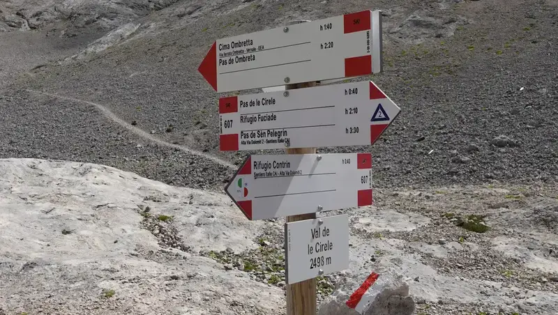
Follow the signs for Val de Contrin, see the photo with directions and elevation at the start:
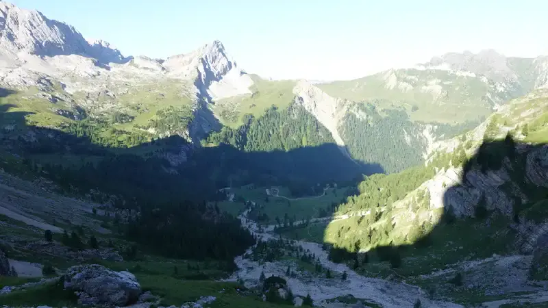
The first section follows a steep road that eventually opens into the breathtakingly wide Contrin Valley. What follows is a long, pleasant walk with minimal elevation gain until you begin the final ascent toward Rifugio Contrin (2016 m).

For context, this path is part of the famous Alta Via 2. From the Rifugio, continue upward toward Passo Ombretta, following route 606 and then 610.

Throughout this climb, the incredible South Face of the Marmolada will be looming on your left. The final stretch below Passo Ombretta (2702 m) is steep and grueling; during peak season, you will likely see hikers struggling on this section.
The pass itself is a wonderful spot. If you arrive early on a clear day, you can enjoy the sunshine after the long, shaded climb up the western slopes. This is the place where the route from Malga Ciapela joins the Contrin valley route to the summit, see the photo below.
From Pas de Ombretta to the summit. Bivacco Marco Dal Bianco
Less than 150 meters from the pass, you will find a shelter nestled against a large rock: Bivacco Marco Dal Bianco.
Because it sits on the popular AV2 route, it is often crowded; you may find ten or more people vying for the nine available beds. Those who arrive late often pitch tents outside, but flat ground here is very limited.
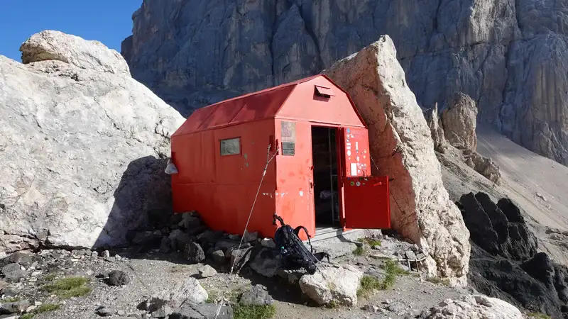
Note that this is an alpine bivouac, primarily intended for alpinists tackling the South Face of the Marmolada. If you are a standard hiker or mountaineer, please be mindful that climbers often rely on this shelter for safety. Avoid planning an overnight stay here unless absolutely necessary.
Just above the bivouac, you will encounter a few cables. These are straightforward, and via ferrata equipment is not required for this specific section.
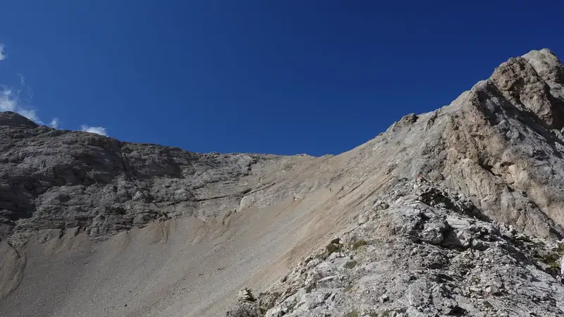
Beyond the cables, the terrain becomes more difficult with a section of loose scree before you reach the pleasant ridge, the route number here is 650.

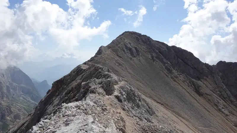
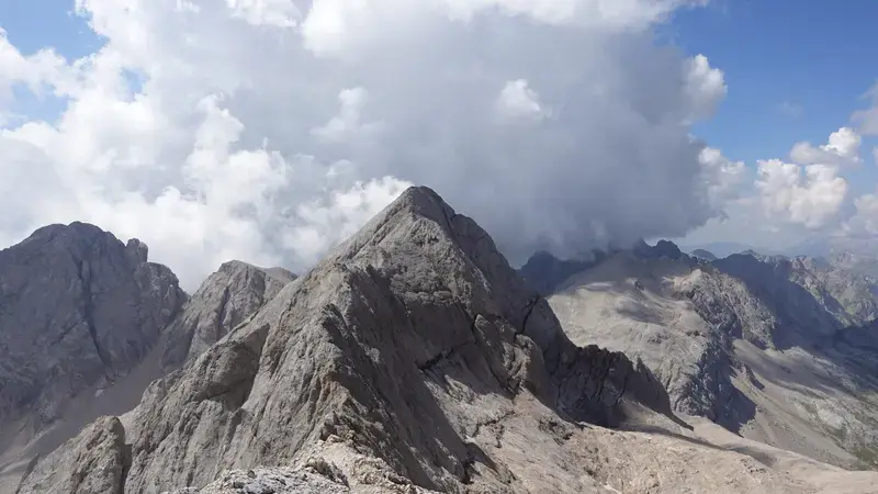
When you get to the ridge, elevation is 2940 meters. The lower peak on your right side is Ombretta di Mezzo (2983), the photo below.
Here is the view back from the ridge to realize how mild it is; the center-right peak in the distance is Gran Vernel, and Marmolada wall is partly visible on the right. Passo Ombretta is far below on the right, and the access scree route is visible.
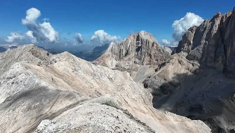
This ridge is the best part of the route, easy to walk, with just some 50 meters of elevation gain, and with incredible views. The Ombretta Orientale summit is not so prominent, and it is overshadowed by Marmolada on the north side and Sasso Vernale on the south side.
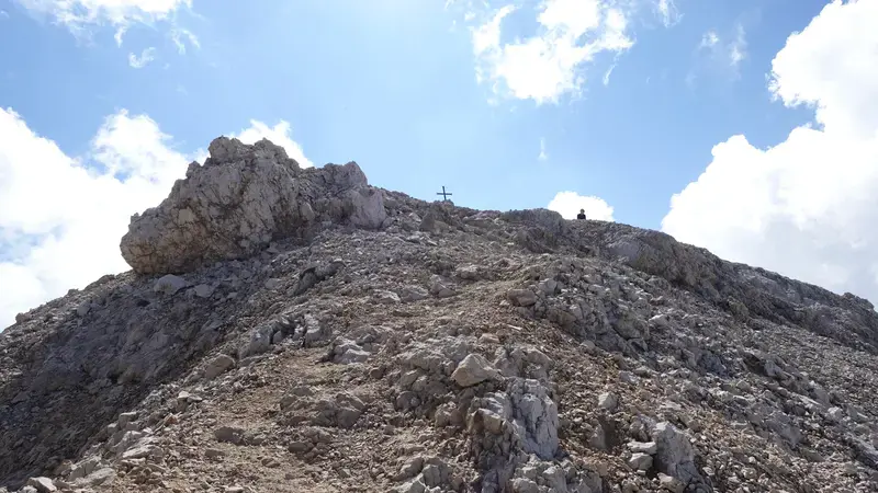
The summit is with a small and simple cross, plenty of space to sit and enjoy the views. Marmolada and Sasso Vernale are true kings here:

Descent route: Ferrata Ombretta-Vernale
From the summit, you can walk back the same way. But you might want to make the tour more interesting and make a loop by descending down the south slope and switch back to the route 650 again.
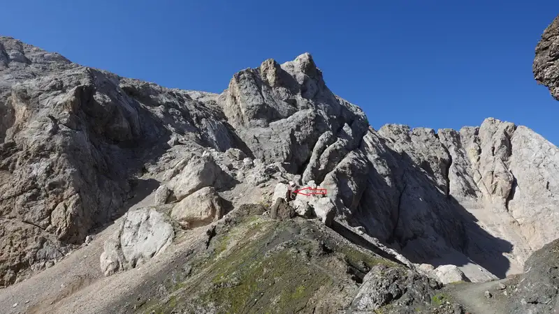
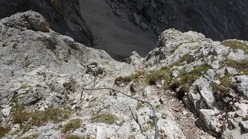
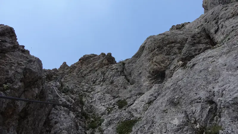
That initial slope is so simple and inviting, but you will make a mistake if you go without ferrata equipment. Have a look at the photo below to better understand what will be waiting for you.
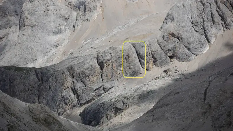
The Ferrata Ombretta is actually a part of the Sasso Vernale massif, this is why it is called also Ferrata Ombretta-Vernale. In my view, it should be called Ferrata Vernale.
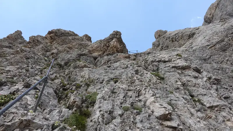
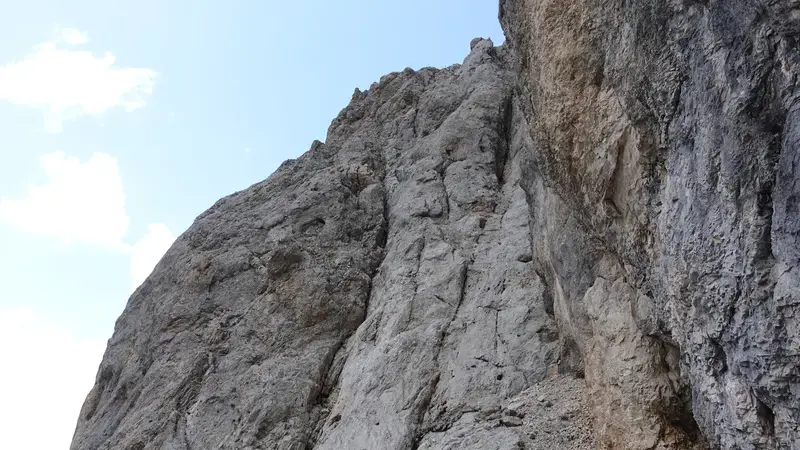
Anyhow, it is located in the area marked by the yellow block shown in the photo above. Below you can see the upper part of the ferrata as I was descending it.
When you descend here, you can pack your ferrata equipment, you will not need it. From this point you can walk in the following directions:
- To Passo San Pellegrino.
- To Val de Cirele and then i) either to Rifugio Contrin and to Canazei, or ii) to Val San Nicolo and farther to San Giovanni di Fassa.
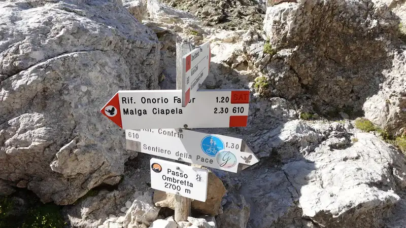
- However, you can also walk up to Passo di Ombrettola, and then climb Sasso Vernale or descend to Malga Ciapela.
Plenty of options, dependent on your stamina and weather conditions, see the info on the signs here:
My rating of Via Ferrata Ombretta-Vernale
I have already shown how the area looks, and here is my rating based on three essential criteria, and assuming that you walk all the way up from the car parking:
| Rating Criteria | Rating (A-E; 1-5) |
|---|---|
| Technical difficulty | C |
| Ferrata length | 1 |
| Access route difficulty | D |
| Overall Score | C1D |
This is a very steep but also very short passage of up to 50 meters or so. The cables are in a very good state. I descended it, not climbed, so my rating may be affected because of this. Regarding technical aspect, I would put it in the same group as Ferrata Averau.
On the other hand, access is long and hard regardless of the direction you choose to get here, hence my rating D.
My tour to Cima Ombretta Orientale
I parked above the village of Penia and started my walk back to the trailhead at 5:45 am. Finding the route was straightforward, and I soon found myself truly enjoying the Contrin Valley. The early hour meant I had the place completely to myself, no people around at all.
I passed the hut at 7:30 am and continued the climb toward Passo Ombretta, reaching it at 9:20 am. The pass was lively, occupied by a large group of young people who were resting and waiting for one struggling member I had passed minutes earlier.
They were bound for Malga Ciapela, so I moved on to the right and was surprised by the proximity of the Bivacco to the pass.
At the bivouac, I met a couple from Colombia. They had spent the night there and informed me that a total of 11 people had lodged inside.
From there, I continued to the summit where I arrived at 10:55 am. I encountered no one on the way up, and only one person was at the top when I arrived. After we exchanged a few words, he departed, leaving me alone for more than one hour and a half to savor the views and my breakfast. The weather was perfect, and I felt no need to rush.
My plan was to complete a circular route over the via ferrata, so I descended toward it. I arrived at the start just as a couple finished climbing. They warned me to be very cautious, describing the ferrata as “extremely dangerous.”
I put on my equipment and began my descent. It was nearly vertical, but by utilizing the cables, effectively “cheating”, the climb-down was easy enough. I was ready to rate it a ‘B’, yet I knew that would certainly be an underestimate.
Below the wall, I debated climbing up Sasso Vernale, but frankly, I felt a little tired.
Realizing my water reserve was low provided a convenient excuse to skip it without having to admit the day was perhaps getting a bit much. But I was sure I would climb it, and I did it a few days later from Passo San Pellegrino; so follow the link to see more.
Just then, someone arrived, and I was astonished to realize it was Tomáš, a friend from my Facebook group, Dolomites Visitors Hub. Salute, my friend! He was heading up, planning to sleep at the bivouac. He later confirmed that the shelter had housed 11 people again.
After that pleasant meeting, I descended toward Rifugio Contrin, meaning this part of the route was also new to me. The final stretch retraced the lovely path I had taken that morning, which I enjoyed once more.
This time, Rifugio and Contrin valley were full of people; families and also bicycle riders who come here on a loop route from San Giovanni di Fassa. Not surprising, the weather was simply perfect.
All the tour is presented in my video, please have a look:
What gear to use for this tour?
If you do the tour described here, you need a full ferrata set, and this means a harness, a Y-rope, and a helmet. But if you descend from the summit the same way back, no need for this.
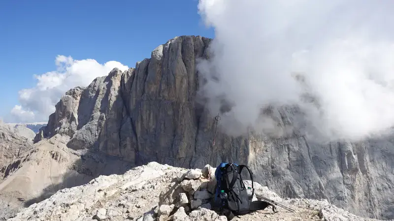
I used Mammut Sapuen GTX boots, a pair of trekking poles, and my Mammut Lithium 40 backpack (see the photo below). Gloves for cables are definitely necessary, and I used them.
In the backpack, as usual, I had a rain poncho and rain pants, plus a rain jacket. If you do not have any and not sure what to choose, think about the Mammut Crater Pro HS which I use myself.
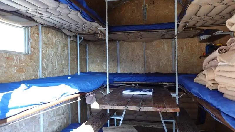
If you want to stay the night in the bivouac, make sure you have your own sleeping bag.
When you are up above Rifugio Contrin, there is no water anywhere on the route. So make sure you have enough for what you plan to do.
Do you want to walk this route?
As you realize, I walk solo, but I have been in this for 40 years already. If you have some mountaineering experience, you can do this tour too.
However, if you want to play safe, which I warmly advise, get in touch with some experts and guides who can help you getting here.
Final thoughts
In summary, Cima Ombretta Orientale isn’t the most famous peak in the Marmolada group. But it has everything that makes the Dolomites special. You get a long, satisfying approach through a beautiful high valley.
Dramatic views of the Marmolada south face dominate the scene. A pleasant high ridge walk leads to the top. And you can add excitement with a short but intense via ferrata on the descent.
The circular tour described here is demanding. It involves serious elevation gain and a full day out. Yet it rewards you with varied terrain. Upper sections often feel solitary, especially with an early start. You finish with the satisfaction of a true loop in a stunning mountain corner.
Choose the simple out-and-back to the summit. Or include the ferrata for the complete round tour. Either way, this is a classic Dolomites day. It feels properly alpine. No advanced climbing skills needed.
If the weather holds and your legs are strong, go for it. You won’t regret that unassuming summit. Marmolada towers nearby. Half of Val di Fassa lies below. Safe travels on the trails. See you in the mountains.
Thank you for reading. Let me know if you have questions or comments, there is a comment section below.
Note that I also have a book titled Dolomites Solo, so have a look if you plan to do some mountaineering tours in the area.
Please join us at our Facebook group Dolomites Visitors Hub.
Frequently Asked Questions
What is the best time of year to climb Cima Ombretta Orientale?
The best period is from late June to early October. Trails are usually snow-free then. Early summer brings wildflowers. Autumn offers golden larch colors and clearer skies. Late August and September often have the most stable weather and fewer people.
Avoid peak July weekends if you prefer quieter trails. Winter ascents are possible with proper equipment, but they demand avalanche knowledge and winter mountaineering skills.
Are there any permits required for this hike?
No permits are needed for day hikes in the Dolomites, including the Marmolada area. The trails are freely accessible. If you plan to stay overnight in a rifugio, book ahead, spaces fill quickly on popular routes like Alta Via 2. Drivers from outside the EU may need an international driving permit, and some high passes close in winter.
What are some safety tips for the via ferrata section?
Clip into cables one person at a time when moving together to avoid both falling at once. Keep distance between climbers to reduce rockfall risk.
Always check the forecast, avoid ferratas in rain, strong wind, or thunderstorms, as metal cables can conduct lightning. On long approaches, prevent blisters by taping hot spots early and keeping toenails short.
What are alternative hikes or nearby peaks if this one is too challenging?
For something easier, try the walk from Malga Ciapela up to Malga Ombretta, great Marmolada views with less elevation gain. The Padon Ridge loop offers moderate effort and wide panoramas. You could also start higher from Rifugio Falier for a shorter version toward the Ombretta area.
From Passo San Pellegrino, the Forca Rossa trail gives similar scenery with gentle meadows and hut options.
Leave a Reply