In the late 19th century, the Julian Alps were a battlefield of stone and signatures. The German-Austrian Alpine Club (DÖAV) was rapidly colonizing the peaks. They built high-end huts and marked every trail with German signage. To the local Slovenes, the mountains were becoming foreign territory.

The First Foothold (1871–1887)
Slovenians answered with wood, stone, and iron. The oldest mountaineering site on Triglav is not a grand lodge, but a failed experiment.
In 1871, local guide Jože Škantar built a wooden shack known as the Triglav Temple on the plateau beneath the south face. The structure did not survive the winters. Wind and snow tore it apart within a few years.
Maria Theresa Hut
Yet the mentioned site endured. It became the fixed base for the southern ascent. In 1877, the DÖAV moved in. They replaced the ruins with the stone Maria Theresa Hut (now Dom Planika), the marker 1 in the map below.
An extension followed in 1880. In 1911, the structures were connected and enlarged. After 1945, the lodge was renamed after the edelweiss, planika in Slovenian. By location and continuity, Planika is the pioneer of high-altitude shelters in Slovenia.
Deschmann-Haus
Ten years later, in 1887, DÖAV opened the Deschmann Haus (Dežmanova koča) at 2332 meters. This hut is now known as Dom Valentina Staniča.
It secured the Kot Valley approach to Triglav. Its stone walls were permanent from the start. For decades, it stood as a German-speaking outpost in the high Julian Alps. Only after the Second World War was it renamed for the Slovenian mountaineer Valentin Stanič (the marker 2 in the map).
These were the first permanent, high-altitude stone structures in what is now Slovenia.
The Resistance (1894)
Slovenian mountaineers realized they were being pushed off their own summit. In 1894, the newly formed Slovenian Mountaineering Society (SPD) built Orožnova koča below Črna prst, the marker 5 in the map. It was the first hut designed, funded, and operated by Slovenians for Slovenian climbers.
In practical terms, it was small. In symbolic terms, it was decisive. It showed that the local community could match the infrastructure of the larger Austrian clubs.
It was a statement of presence, but the main peak, Triglav, remained under German control.
The 1-Florin Maneuver (1895)
The conflict reached its peak in 1895. Jakob Aljaž, a parish priest and climber, executed a brilliant legal strike.
On April 15 of that year, he bought 16 square meters on the summit of Triglav and a parcel on the nearby Kredarica plateau from the Dovje municipality, the marker 6. He paid one Austro-Hungarian florin.
It should be noted that under Habsburg cadastral law, high alpine terrain was typically registered as municipal communal land. The Triglav summit fell within the cadastral boundaries of Dovje, giving the local council legal authority to sell small parcels.
In any case, the sum was small, roughly the price of a few loaves of bread or a couple of liters of wine at the time. The effect was not. By owning the summit, he gained the legal right to build, and to refuse others permission.
This purchase made Aljaž the legal landlord of the highest point in the land. The DÖAV could no longer build there without his permission.

Building the Symbols (1895–1896)
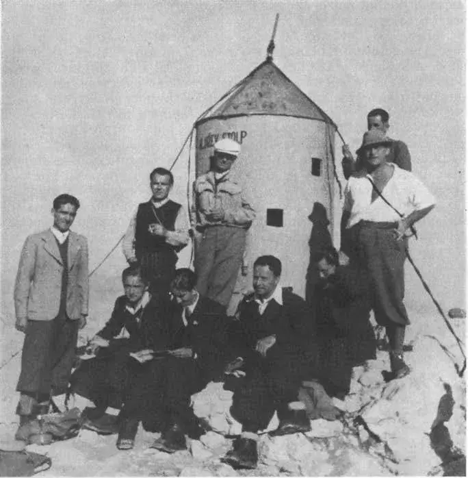
Aljaž moved fast. The parts of a small iron tower were carried up over the course of a week. Six porters hauled six modular sections, each weighing between 15 and 20 kilograms. On August 7, 1895, the final assembly took five hours. The result was Aljažev stolp (Aljaž Tower), the marker 4 in the map.
It was a modular cylinder of galvanized iron. It served as a landmark, a Faraday cage, and the first piece of Slovenian signage on the peak. The tower was/is 1.90 meters high and 1.25 meters wide.
Anchored into limestone with heavy rods, it acts as a Faraday cage. In a lightning strike, current flows around the exterior. Inside, a climber is shielded from the electrical surge.
But the same metal that protects also amplifies sound. A direct strike turns the cylinder into a resonating bell. The noise can rupture eardrums and disorient anyone inside. It was designed for four or five people in an emergency. In 1895, that meant survival on a summit with no natural shelter.
Aljaž realized the Aljaž Tower was too small (only 1.25 m wide), so he had workers blast and carve into the rock what is known as the Stanič Shelter (the marker 7). This isn’t a building; it’s a man-made cave/shelter.
It is 55 meters below the summit and the dimensions are 2.4 x 2.2 x 2 meters. Regarding capacity, it was designed to fit 8 people sitting or 16 standing. It still exists, but it lost its importance the moment the Kredarica hut opened in 1896, more below. Most people today just see it as a “hole in the rock” near the summit ridge.
Aljaž’s purchase was surgical. He bought the absolute peak to control the “prestige” and the Kredarica plateau to control the “base.” The 55 meters of vertical rock in between remained technically “communal land” belonging to the municipality of Dovje.
Because Aljaž was the parish priest of Dovje and had a very close relationship with the municipal council (the same people who sold him the summit for 1 florin), he had “de facto” permission to improve the mountain.
The Logic: Blasting a hole into a cliffside was seen as a safety improvement for the parish’s guides and hunters, not a “building” that required the same complex deed as a summit tower or a valley house.
Why “blasting” instead of “building”? Aljaž chose to blast a cave precisely because of the property and weather constraints. A cave isn’t a “structure” in the same way a hut is. It has no roof to blow off and no walls to be declared “illegal” by the Austrian authorities. It is simply a modification of the existing rock.
Zero footprint: On the steep summit pyramid of Triglav, there is almost no flat ground. By carving into the mountain, he created space where none existed, without needing a foundation.
The functional layout: If you are at the summit (Aljaž Tower) and a storm hits, you are in a Faraday cage. If the storm is sustained or the tower is full, you descend the ridge to the Stanič Shelter.
Location: It is situated on the southern side of the summit ridge, sheltered from the biting north winds.
It was named after Valentin Stanič, the priest-alpinist who made the first recorded tourist ascent of Triglav in 1808 and measured its height. Aljaž wanted the Slovenian presence on the mountain to be anchored by historical Slovenian names.
So although the Stanič Shelter was not on Aljaž’s private 16 m² plot, the shelter was a tactical “safety excavation” authorized by the local Dovje council. By blasting into the cliff rather than building on top of it, Aljaž avoided the legal injunctions the German clubs used against his “structures.”
The Legal War
The DÖAV sued Aljaž, claiming the tower was an illegal construction. During the trial, Aljaž produced his deed for the 16 square meters.
He argued that as a private landowner, he had every right to place a “shelter” on his property. Aljaž’s documented ownership prevented any formal removal.
The Kredarica Purchase (1895)
Aljaž realized that owning the summit was a great defensive move, but it didn’t provide a place for Slovenians to sleep. To truly “own” the route, he needed a base camp.
He bought a substantial plot on the Kredarica plateau (2515 m) and he paid 5 gold florins for the Kredarica land. For a grand total of 6 florins, Aljaž effectively secured the legal future of Slovenian mountaineering.
Why Kredarica was the “Real” Battlefield?
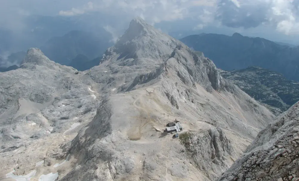
The German-Austrian Alpine Club (DÖAV) already had their eye on Kredarica. It is the most logical place for a hut because it’s the last flat spot before the final ridge, see the photo below.
By purchasing the land privately in April 1895, Aljaž “blocked” the DÖAV from building there. He didn’t waste time. He started construction almost immediately, and by August 1896, the first Triglavski dom na Kredarici was opened.
It was the first “grand” Slovenian hut. Unlike the small Orožnova koča (1894), Kredarica was built to compete directly with the Austrian lodges in terms of size and service.
The contract was signed between Aljaž and the Municipality of Dovje. The locals were fully on Aljaž’s side. They knew that if they sold the land to the German clubs, the local guides might lose their influence. Selling to their local priest was a way for the village to keep control of their mountain.
This hut sat on the plateau he had also purchased, finally breaking the German monopoly on the mountain’s high-altitude infrastructure.
It became the highest hut in Slovenia and the country’s highest meteorological station. Expanded several times, it remains the main base for the final ascent from the north.
When the Triglavski dom na Kredarici opened, it wasn’t just a grand opening; it was a declaration of war. The DÖAV (German-Austrian Alpine Club) did not take the loss of the mountain’s “prime real estate” lightly.
The “Petty” Geography War
Because Aljaž owned the land on Kredarica, the DÖAV couldn’t stop the construction. Instead, they tried to make the hut irrelevant.
The DÖAV began marking trails from the valley that bypassed Kredarica entirely, directing hikers toward their own huts (Maria-Theresia/Planika and Deschmann/Stanič).
On German-language maps, they refused to acknowledge “Triglavski dom.” They labeled it as a “Slovenian shelter” or simply left it off the maps entirely, trying to keep German tourists from spending money at a Slovenian-owned lodge.
The Economic Competition
The DÖAV used their superior funding to upgrade their nearby huts to a “luxury” standard.
They expanded the Maria-Theresia hut (Planika) to offer better food, warmer beds, and more “refined” service than what the local Slovenian priest could offer at Kredarica.
The DÖAV tried to hire all the best local guides exclusively for their members, essentially attempting to “starve” the Slovenian hut of visitors.
The Climax: The 1906 Expansion
Aljaž and the Slovenian Mountaineering Society (SPD) realized that a small wooden hut wasn’t enough. They had to go bigger. In 1906, they significantly enlarged the Kredarica hut.
They added a small chapel nearby, dedicated to Our Lady of the Snows. This was a brilliant move by Aljaž. By making Kredarica a site of religious pilgrimage as well as mountaineering, he ensured a steady flow of local Slovenians that the DÖAV could not discourage.
The Final “Checkmate”
The rivalry only truly ended because of geography and weather. Kredarica sits at 2515 meters, making it the highest hut in the region.
It is the most natural “jumping-off point” for the summit. No matter how much the DÖAV upgraded the other huts, climbers naturally gravitated to the highest, most convenient spot.
So, by the early 1900s, Triglav had a “dueling” infrastructure. You had the German side (Planika and Stanič) and the Slovenian side (Kredarica). It remained this way until 1918, when the Austro-Hungarian Empire fell, the German clubs were expelled, and all the huts were eventually handed over to the Slovenian mountaineers.
The Legacy
Aljaž understood symbolism as well as engineering. The tower bore the inscription “Aljažev stolp.” It was the first Slovenian word displayed on the summit, where all other signage had been in German.
Inside, he placed a summit book, three stools, a spirit stove, and a panoramic painting of the surrounding peaks. These details were not decorative. They defined the structure as a functional refuge, strengthening its legal status.
Today, those 16 square meters remain the most significant real estate in Slovenian history. The towers and huts stand as monuments to a time when mountaineering was an act of national survival.
The tower’s appearance changed with politics. It was repainted under different regimes, including a bright red phase with a red star during the Yugoslav period.
After Slovenia’s independence in 1991, it returned to its original grey. In 2018, it was lifted by helicopter for full restoration. Beneath layers of paint, conservators found the original 1895 metal plates intact.
The tower and the hut still stand. They remain the most significant pieces of mountaineering real estate in the country, purchased for the price of a few loaves of bread.
I myself have visited them for the first time in 1986. This was my first solo mountaineering tour to a serious high elevation mountain. On my way up, I followed Tominšek route and spent a night in the Kredarica hut. I described this in a separate text.
This was without a camera, so I do not have any photo of the area although I climbed the mountain again in 1987, that time over Plemenice (Bamberg route) and descending by Tominšek route, 11 hours up and down in a single day.
A Note on DÖAV
The DÖAV was mentioned a few times in the text above, so here are some details about it. DÖAV stands for Deutscher und Österreichischer Alpenverein. It wasn’t born as one club; it was a strategic merger:
- 1862: The Austrian Alpine Club (ÖAV) was founded in Vienna (the first on the European continent).
- 1869: The German Alpine Club (DAV) was founded in Munich by climbers who wanted a more “active” approach (building huts and trails) rather than just scientific lectures.
- 1873: The two clubs merged in Nördlingen to form the DÖAV. They realized that German-speaking climbers from Munich, Berlin, and Vienna were all climbing the same mountains in the Tyrol and the Julian Alps. Combining their membership fees and engineering talent made them the most powerful mountain organization in the world.
The Cultural “Pan-Germanism”
Even though the empires were separate, the DÖAV was fueled by Pan-Germanism, the idea that all German-speaking people shared a single cultural and “Alpine” identity.
The goal: they viewed the Alps as the “homeland” of the German spirit.
The result: This is why you see “German” huts like the Deschmann-Haus (Stanič Hut) being built deep inside Slovenian-speaking territory.
To the DÖAV, it wasn’t about imperial borders; it was about where German speakers hiked and lived.
The Scale of the “War”
Because they were a single club representing two empires, their resources were massive compared to the local Slovenian SPD (founded in 1893).
Remember that Slovenia was a small and insignificant part of Austro-Hungarian empire. It was not a separate identity. It was a collection of crown lands (Carniola, Styria, Carinthia) within the Austro-Hungarian Empire.
Because everyone involved, the Slovenians, the Austrians, and the Sudeten Germans, were technically subjects of the same Emperor (Franz Joseph I), the conflict was about ethnic identity, not national borders.
DÖAV had tens of thousands of members, extensive membership funding, and professional engineers. SPD had a few hundred members, funded by local donations and the pockets of people like Jakob Aljaž.
This explains why Aljaž’s purchase of the summit for 1 florin was so vital. He couldn’t outbuild the combined wealth of Germany and Austria, so he had to outmaneuver them legally.
The Post-War Split
The “DÖAV” remained a single entity through WWI and the inter-war period. It wasn’t until after WWII (1945) that the clubs were forced to separate again into the modern DAV (Germany) and ÖAV (Austria). This was largely due to the Allied administration’s rules on nationalist organizations.
More About the Value of Aljaž Purchases
Here is what one florin actually bought in the 1890s:
- A skilled stonemason earned about 1.5 to 2 Florins per day.
- A kilogram of beef cost about 0.50 Florins.
- A train ticket from Ljubljana to the mountains (third class) was roughly 1.20 florins.
In the eyes of the local municipality, Aljaž wasn’t “stealing” the land; he was paying a fair administrative price for land that had zero agricultural value.
The reason historians focus on the 1 florin for the summit is the legal status it created. In Austrian law, a transaction of 1 florin was the minimum required to make a contract legally binding and “onerous” (meaning it wasn’t a gift, but a sale).
By paying one florin, Aljaž ensured the DÖAV couldn’t argue that the land was “donated” to him illegally. He was a paying customer with a receipt.
Raising Donations
But Aljaž had to raise donations to actually build the Kredarica hut, which cost thousands of florins compared to the land price.
The initial construction of the Kredarica hut in 1896 cost approximately 3500 florins (700 times the cost of the land).
In 1896, 3500 florins was enough to buy a large, multi-story house in a town or a significant estate in the valley.
Aljaž was a master of grassroots fundraising. He didn’t have the deep pockets of the German-Austrian state-backed clubs, so he relied on three main sources:
1. Personal Savings: Aljaž was not a wealthy man, but he lived frugally. He poured his own salary and inheritance into the project. It’s estimated he contributed several hundred florins personally.
2. The “Slovenian Mountaineering Society” (SPD): The club organized a national campaign. This was the first time “mountaineering” was presented to the Slovenian public as a patriotic duty. Small donations came in from teachers, priests, and farmers across the country.
3. The “Triglav Coins”: To encourage donations, Aljaž “sold” the idea of the mountain to the people. He published articles in newspapers like Slovenski narod, framing the construction as a battle for the Slovenian soul.
Why was it so expensive?
The cost wasn’t in the materials themselves, but in the logistics. There were no roads or pack-animal paths to Kredarica then. Workers and local volunteers carried loads of 30 kg to 50 kg on their backs, climbing thousands of vertical meters daily.
He had to hire professional carpenters and masons who were willing to live in tents on the plateau for weeks, battling snow storms even in July.
Because he was competing with the DÖAV, he couldn’t just build a shack. He had to build a “Dom” (a home) with a dining room and proper guest beds to prove that Slovenians could provide “civilized” hospitality.
The result was the hut opened on August 10, 1896. It was a wooden building with three rooms and 25 beds. It was humble compared to today’s Kredarica (which can hold 300+ people), but it was a psychological victory. Aljaž had turned 6 florins’ worth of rock into a 3500-florin fortress of national identity.
For the construction of the Triglavski dom na Kredarici, the primary transport artery was the Krma Valley.
While Kot is physically closer to the Stanič Hut, Krma was the logistical backbone for the Kredarica project for several technical reasons:
- Krma is the longest and most “gentle” of the glacial valleys. It allowed for a steady, albeit grueling, pace for the porters and pack animals (mules) as far up as the Zgornja Krma pasture.
- The final, steep ascent from the end of the Krma valley to Kredarica is known as Kalvarija. This was the hardest part of the route, where the human chain took over from the animals to haul the timber and lime up to the plateau.
- Krma provided more space for staging materials. In 1896, Aljaž didn’t just need a few iron plates (like for the tower); he needed thousands of kilograms of wood and stone.
- The Kot Valley and the “German” Rivalry: The Stanič Hut (originally the Deschmann-Haus) was the stronghold of the German-Austrian Alpine Club (DÖAV), so the Kot route was effectively “their” territory during the construction years.
Aljaž and the Slovenian builders intentionally focused on Krma to avoid constant friction and because the terrain in Krma was better suited for the sheer volume of material needed for a full “Dom” (lodge).
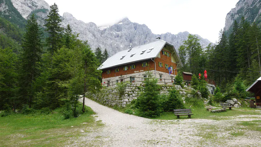
Aljaž Hut
Aljažev dom v Vratih sits in one of the most dramatic “cathedrals” of the Alps, right at the foot of the 1000-meter North Face.
While the summit and Kredarica were about strategy, the Vrata valley was Aljaž’s home. He was the parish priest in Dovje (the village at the mouth of the valley), so this was his backyard.
Aljaž bought the land in the Vrata valley in 1895, the same “miraculous year” he secured the summit.
He purchased the plot from the Dovje municipality. Just like on the heights, the German-Austrian Alpine Club (DÖAV) wanted this spot. They already had a small, private hut nearby (the Triglav-Hütte), and Aljaž knew that if they built a major base in Vrata, the valley would be lost to German influence.
As soon as the Kredarica hut was under way, he began work in the valley. The first hut was opened on August 9, 1896, just one day before the grand opening of Kredarica.
It was a simple wooden building. It didn’t look like the large stone/wood complex you see today, see my photo below. It was designed to be a “welcoming room” for Slovenians before they started the brutal climb up the “Prag” or “Tominšek” routes.
The Tragedy and Rebirth (1904–1910)
The Aljažev dom you visit today is actually the second version. In the winter of 1904, a massive avalanche from the slopes of Stenar swept down and completely destroyed the original wooden hut.
Aljaž didn’t give up. He raised more funds and built a new, much sturdier hut in a slightly safer location nearby.
The “new” hut, the one that forms the core of the modern structure, was opened in 1910.
Aljaž used this hut as his tactical base. This is where he started marking trails with the “Knafelc circle” (the white dot inside a red ring), replacing the German markings.
He also built the Chapel of St. Cyril and Methodius nearby. He wanted to ensure that the valley felt culturally and spiritually Slovenian from the moment a hiker stepped into it.
Building Tominšek Route
The Tominšek Route was named after Fran Tominšek, a co-founder of the Slovenian Alpine Club. This was Aljaž’s direct “counter-attack” to the Prag Route.
The Prag Route was the older, traditional path. By the late 1890s, the German clubs (DÖAV) claimed it as “theirs.”
Aljaž and Tominšek wanted a route that was purely Slovenian, planned, marked, and funded by the SPD. It was opened in 1903.
It is significantly steeper than the Prag, but it gets you from the Vrata Valley to the plateau much faster. Aljaž wanted his hikers to reach the summit before the “others” could occupy the space.
The Engineering of 1903
Building the Tominšek was a masterpiece of “barefoot” engineering. Unlike modern routes that use chemical anchors and thick steel cables, the original Tominšek was secured with simple iron rungs forged in the valley and hammered into the limestone.
The exposed traverse across the ledges (police) above the Vrata Valley was designed to be terrifying enough to keep the “casual” tourists away, but accessible enough for the hardy Slovenian hikers.
The route is famous for its “exposed” sections where you look straight down 500+ meters into the Vrata Valley. It remains one of the most beautiful ways to see the North Face (Slovenian: Stena) from the side as you climb. Even today, with modern steel cables and pegs, it is a formidable climb.
My Own Experience
This route was for me in 1986 my first major mountain experience, my “baptism by fire.”
That is a terrifying story. I did not have any experience, any equipment, not even a torch. But it appears that I had what mountaineers call “a very busy guardian angel.”
Started at around 5 pm (as I said, I was a stupid beginner, nobody goes up the mountain at that time), I was at the hut around 10 pm from what I remember. Here is the technical reality of how I likely managed that “impossible” 5-hour ascent.
In summer, the Julian Alps have a very long twilight. Even after the sun drops behind the towering walls of Stenar or Razor, the limestone of the North Face acts like a giant reflector.
White limestone retains a “ghostly” light for about 40–60 minutes after sunset. This probably gave me just enough contrast to see the white rock against the dark abyss of the Vrata valley for the first few hours.
By 8 or 9 pm, I would have been in the “black zone.” At that point, I was not “hiking” anymore, I was feeling.
I probably navigated the final sections by the sound of my boots. The “crunch” of the scree on the path sounds different than the “clink” of loose rocks near a ledge.
As I neared the plateau, I had one thing saving me, the hut. Even in 1986, the Kredarica hut was a hub of activity. From what I remember, the light from the windows was visible occasionally.
Most likely I also heard the low hum of the diesel generator long before I saw the building. In the silence of the high Alps, sound carries for miles. I wasn’t finding my way; I was “homing in” on the noise and light.
There is also a certain “beginner’s luck” where, because I didn’t know how dangerous it was, I didn’t freeze with fear. But let’s get back to the main topic.
Here is a short video I made when I was there 38 years later:
After Aljaž
When Jakob Aljaž died in 1927 at the age of 82, he didn’t just leave behind buildings; he left a meticulously planned legal legacy. He knew that if he owned the properties personally, they could be tied up in inheritance disputes or seized by the state.
The Pre-Emptive Donation
Aljaž did not wait until his death to secure the mountains. In 1900, just five years after purchasing the summit and building the first tower, he formally donated the Aljaž Tower and the land on the summit to the Slovenian Mountaineering Society (SPD).
He wanted to ensure that the “Symbol of Slovenia” belonged to the people through their official organization, making it untouchable by his own heirs or private creditors.
He remained the “caretaker” and the face of the mountain until his final days, but legally, he was no longer the owner.
The Fate of Kredarica and the Valley Huts
As for the larger properties, like the land at Kredarica and the Aljaž’s Hut in the Vrata Valley (Aljažev dom v Vratih), these were also transferred to the SPD. Aljaž had raised the money for them through the society and his own funds, but he always viewed himself as a trustee for the nation.
After his death, the SPD (which later became the PZS – Alpine Association of Slovenia) took full control. They used his foundation to expand the huts.
Kredarica, which Aljaž built for 3500 florins, was expanded multiple times to become the massive facility it is today, capable of housing hundreds of people.
The 1927 National Mourning
When Aljaž died in the village of Dovje, it was treated as a national day of mourning.
Thousands of people gathered in Dovje. He was buried in the village cemetery, positioned so that his grave looks directly up at the North Face of Triglav, the mountain he “bought” to save.
His house in Dovje and the parish office became informal sites of pilgrimage.
Aljaž died “poor” in terms of money, having spent almost every florin he earned on the mountains. However, by donating his 1-florin summit and his 5-florin plateau, he became the ultimate landlord of Slovenian identity.
Legal Protection in the Modern Era
The donation Aljaž made in 1900 stood the test of time and three different regimes (The Empire, the Kingdom of Yugoslavia, and Socialist Yugoslavia).
In 1999 the Slovenian government officially declared the Aljaž Tower a cultural monument of national importance.
Even today, the tower is managed by the National Museum of Slovenia and the Alpine Association, fulfilling Aljaž’s wish that it never fall into private or foreign hands again.
Italian Episode: The “Divided” Tower
This is one of the most surreal chapters in mountaineering history. After World War I, the Treaty of Rapallo (1920) redrew the map of Europe, and the new border between the Kingdom of Italy and the Kingdom of Yugoslavia was drawn exactly across the summit of Triglav. This created a bizarre geopolitical situation for climbers.
Some sources claim that the border passed directly through the Aljaž Tower, but this seems to be a common popular exaggeration or simplification.
But from what I was able to find online, it appears that the tower was positioned just inside Yugoslav/Slovenian territory, specifically, about 2 meters inside the Yugoslav side. A border stone/marker stood beside/next to the tower, with the actual line running alongside it rather than directly through the structure.
The Iron Curtain of the Alps
This led to a “color war” that lasted for years. Italian nationalists would climb up and paint the tower in the Italian Tricolore (Green, White, Red). Slovenian patriots would then hike up and paint it back to its original grey or cover it in Yugoslav colors.
At certain times of high tension, soldiers were actually stationed near the summit. To cross from the Kredarica side (Yugoslavia) to the Seven Lakes side (Italy), you technically needed to cross an international frontier at nearly 2900 meters.
The Italian “Annexation” of the Huts
Because of this new border, the two “German” huts we discussed earlier were split up:
- Planika (Maria-Theresia-Hütte): Fell on the Italian side. The Italians renamed it Rifugio Alessandro de Regny.
- Stanič (Deschmann-Haus): Fell on the Yugoslav side. The Slovenians finally got to officially rename it Dom Valentina Staniča.
- Kredarica: Remained safely in Yugoslavia, continuing Aljaž’s legacy as the main Slovenian base.
Why the Tower Survived
During this time, the tower was at its most vulnerable. It could have been demolished as a “provocation” by either side.
No evidence suggests that private title prevented any Italian claim or demolition attempt. It was more about geopolitics, surveying, and mutual recognition of its neutrality as a landmark.
It survived because both sides eventually realized it was too useful as a navigation landmark and emergency shelter to destroy. It became a neutral “silent witness” to the soldiers shivering in the bunkers just a few meters away.
Later Period and Present Status
After World War II, when borders were redrawn and the area fully became part of socialist Yugoslavia (later Slovenia), the tower was declared a cultural monument.
Today, it’s state-owned property of Slovenia, managed by the Ljubljana Matica Alpine Club (a branch of the Alpine Association of Slovenia), and the land parcel belongs to the Municipality of Bohinj.
In short, private ownership by Aljaž was crucial for its creation and initial survival in 1895. But by 1920 it was long under mountaineering society control, and the interwar border placement (plus its utility) is what kept it on the Slovenian/Yugoslav side through the turbulent period.
Final Thoughts
In summary, in the late 19th century, the Julian Alps were not quiet. They were contested ground. The German-Austrian Alpine Club (DÖAV) was building huts, marking trails in German, and securing the main approaches to Triglav.
The Planika site begins in 1871, rebuilt in stone in 1877. The Stanič site follows in 1887. Orožnova koča marks the first Slovenian-built hut in 1894. The Aljaž Tower claims the summit in 1895. Kredarica crowns the plateau in 1896.
These structures were never neutral. Each one fixed a language, a flag, and a community onto the rock. In the Julian Alps, mountaineering infrastructure became a tool of national definition.
The huts still serve tea and soup. But they were built in a different climate, one where every roofline carried a claim.
Thank you for reading. Let me know if you have questions, there is a comment box below.
Leave a Reply