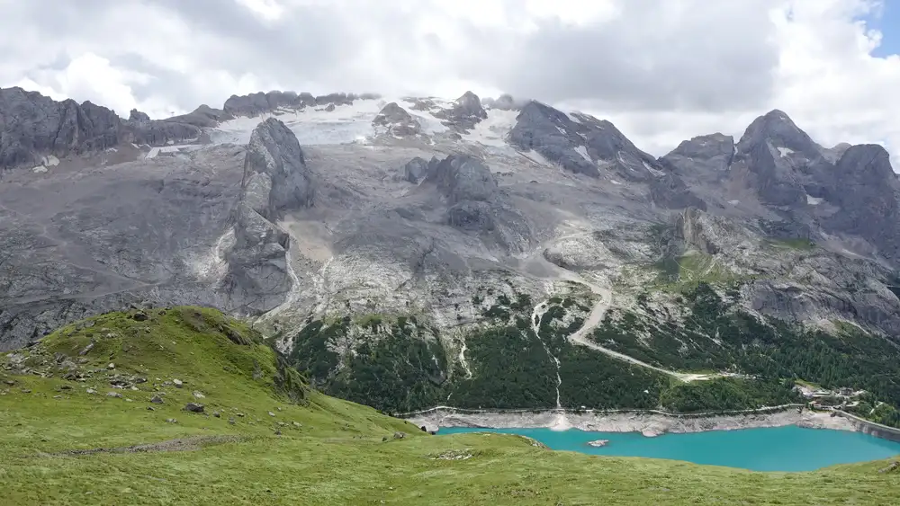
The Bivacco Bontadini is very close to Passo Fedaia, and you can use it as a base to walk the Ferrata delle Trincee from the east side. You will have Marmolada with its glacier in sight all the time.
You can reach Bivacco Bontadini in less than 90 minutes from the parking at Fedaia Lake. The bivouac is basic and offers six wooden sleeping platforms, with no mattresses and no blankets.

Quick facts
- Bivacco Bontadini elevation: 2530 m (8300 ft).
- Coordinates: 46.4634797, 11.8883028.
- Route difficulty: walk-up.
- Elevation difference from the parking: 480 m (1575 ft).
- Parking coordinates: 46.4537733, 11.8874753.
- Time needed from the parking to the bivouac: 90 minutes.
- Sleeping capacity: 6 on the ground level and 6 in the attic.
- No mattresses, no blankets, no stove.
- Nearest place for supplies: Canazei.
- Useful maps:
- Alta Badia Arabba Marmolada, Tabacco 07, 1:25000.
- Marmolada Pelmo Civetta Moiazza, Tabacco 015, 1:25000.
Access roads and map
Below is my interactive and zoomable map where I have added the following markers important for the tour:
- Marker 1: Car parking at Rifugio Fedaia.
- Marker 2: Rifugio Padon.
- Marker 3: Bivacco Ernesto Bontadini.
- Marker 4: Mesolina (Padon) summit.
- Marker 5: Ferrata delle Trincee.
- Marker 6: My descent route.
If you zoom in, you can see many details regarding the route. Zoom out to see the access roads to the area.
Route description
The route starts on the east side of Fedaia Lake and Passo Fedaia. There is plenty of free space to leave the car, and the signs for the tour are right at the road. You follow the direction to Rifugio Padon.
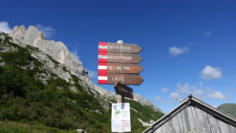
You follow the road, which is closed to the public, and in about an hour you will be at Rifugio Padon. From there, keep walking up in the west direction.

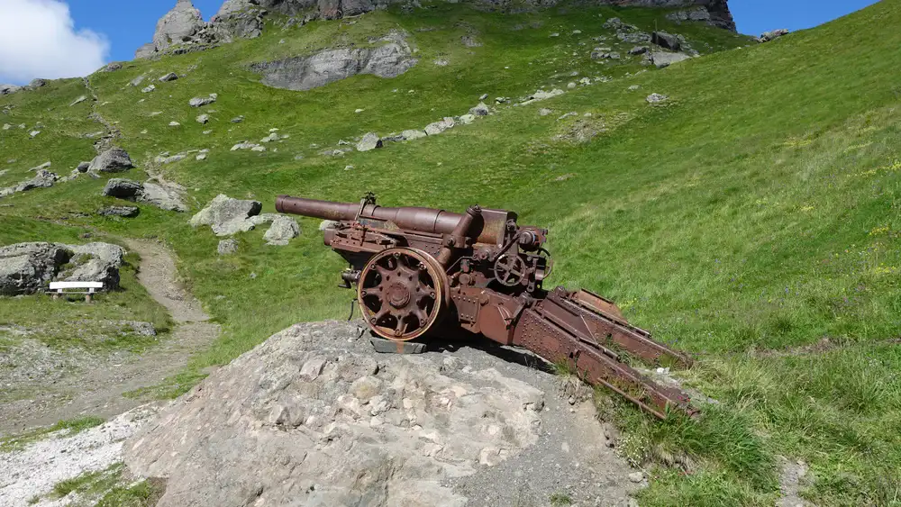
You are now in an area that used to be a front line in WWI. The cannon above Rifugio Padon, shown in the photo, is a reminder of that. In fact, the name Ferrata delle Trincee is also related to this. The word trincee means trenches. Higher up, you will find many of them, plus tunnels and stone walls.
The photo below shows the path. This is the direction toward Bivacco Bontadini.
At Bivacco Ernesto Bontadini
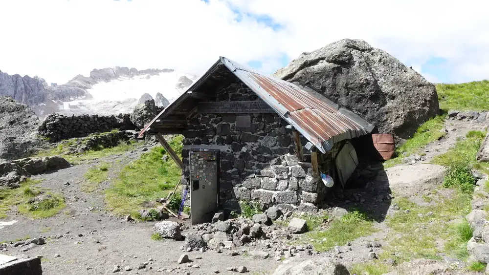
Bivacco Bontadini remains out of sight until you are very close to it. Once there, you can climb the summit of Mesolina (2642 m), but this is not necessarily part of the main route.
The bivouac is a simple stone building. Its rear wall is in fact a single natural boulder. The other three sides are stone walls, with wood on the inside, so the overall feeling of the interior is good.
The bivouac is equipped with four bunk platforms for sleeping, plus two benches built in the same style, and a table. But there is also an attic where 6 people can easily sleep.
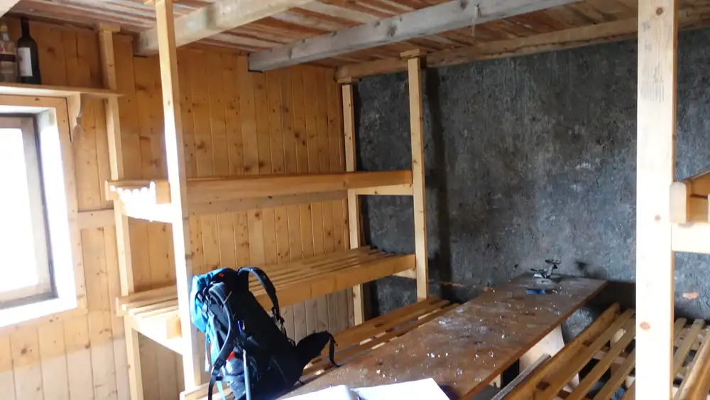
So the sleeping capacity is six plus six or so. But remember that there are no blankets, pillows, or mattresses. In my view, this is better than having dirty and dusty mattresses. I noticed a hole in the floor, so no doubt some small animals can get inside.

Ferrata delle Trincee
If you plan to walk the ferrata, follow the route in the west direction. From my experience, it seems that most people walk the ferrata in the opposite direction, from the west. Most likely the reason is that the most attractive parts of the ferrata are already at the beginning when coming from that side.
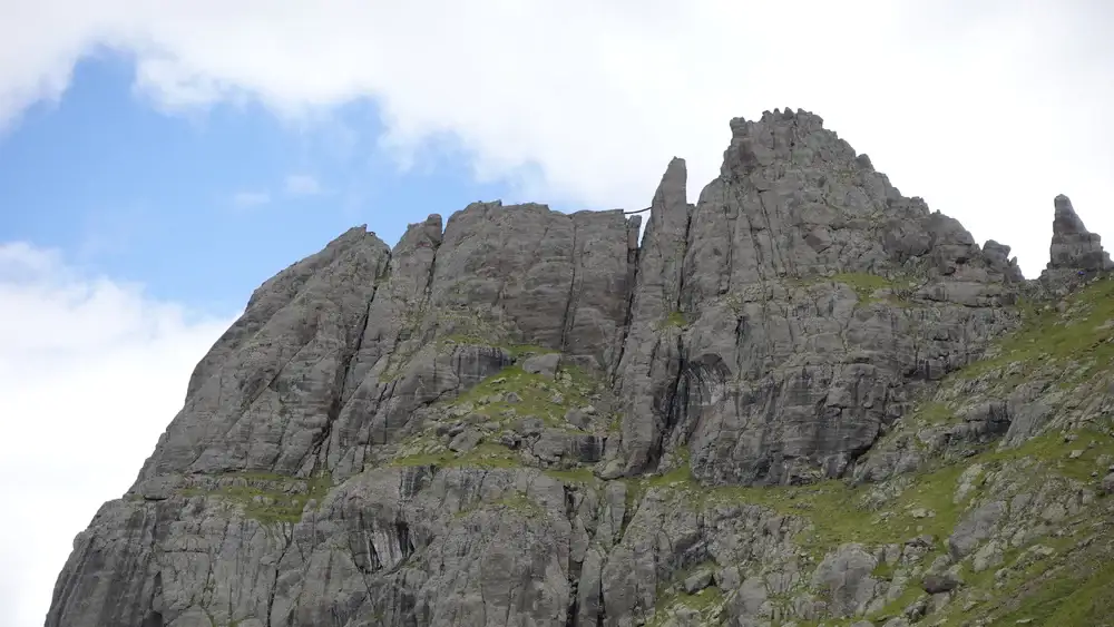
This is a mountain ridge that separates the Marmolada group from the Sella group. The rock is volcanic, and this makes it very different from the two mentioned groups.
The photo below shows my view back toward the east. The route goes mainly on the right side in the photo, but also along the rugged ridge. Note that there are tunnels in that area, but they can be avoided.

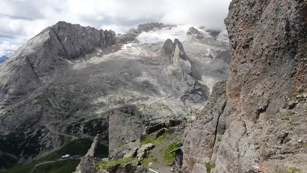
Below you can see the sharpest peak on the west side. It was crowded. I could see people on both sides of the peak. That is why I did not want to go there.

Most of the time this is an easy ferrata, with only a few exposed passages. The map above shows that the first part is rated B. I agree with that.
The map also shows a D rating on the west side. I cannot say much about that part because I did not climb it. This is why I do not give my formal rating for this ferrata as I normally do. I have my own grading/rating system.
Perhaps I will climb that part later and add a few lines here. That section looked more like a tourist attraction, and I did not feel the desire to go there.
If you want to make a round tour, you can descend to the lake and main road in various ways. The photo below shows the view from my descent route, number 680 (marker 6 on the map). This is pleasant grassland the whole way.
My tour
I started from the parking at 9:40 am and arrived at Rifugio Padon at 10:30. I did not make any pauses, and 20 minutes later I was close to the bivouac. After a long rest there, I switched to the route to Mesolina and stayed on the summit for a while. I was alone on the route the whole time.
The photo below shows the bivouac as I approached it from the summit. After a short rest, I continued in the west direction.
I met not more than four or five people on the ferrata ridge section. But as I approached the sharp peaks on the west side, I noticed many people waiting in line for the ferrata. This was confirmed to me also by some of those that I met.
This is why I did not want to go there. I found a shortcut, visible on the map above, and switched to route 680. So this became a walk back parallel to the ferrata ridge above.
That descent route goes back to Rifugio Padon. This time there were many cyclists going in my direction. It seems that they go up using a lift and then use this as a descent route.
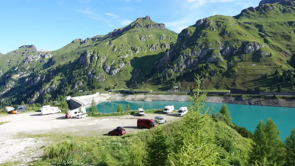
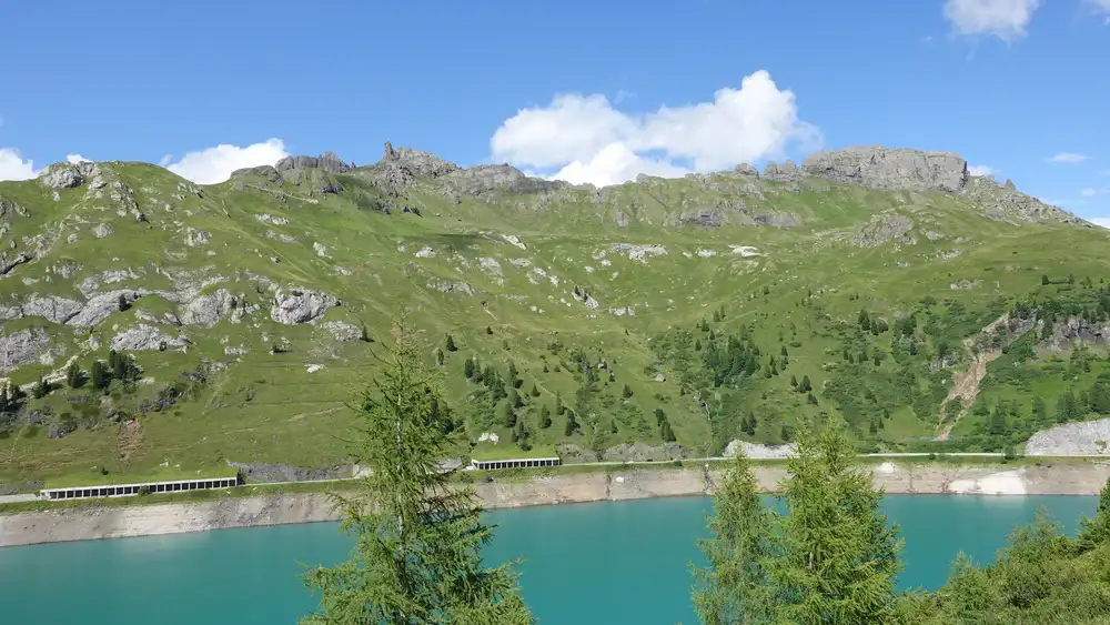
One more thing to mention. The photo below shows free parking on the south side of the lake. To get there, you drive over the dam. Many people sleep there in vans and cars, me included.
From that parking you can enjoy views of the route described above. Here is the view of the area, the ferrata extends along the top ridge. It looks mild from here but the ridge is rugged, with lots of ups and downs.
My route went from right to left. I descended when I was close to the finger-shaped sharp peak on the left. From there, I walked below the ridge completely to the right, and outside of the photo.
All the tour is presented in my video, please have a look:
Gear, water, food & accommodation
For this tour I used Nortiv 8 boots. I had a pair of trekking poles, and my Mammut Lithium 40 backpack.
The sky was clear in the beginning, but this changed later. You can see this in the photos. This is why, as usual, in my backpack I had a rain poncho, rain pants, and a rain jacket. If you do not have a jacket and are not sure what to choose, consider the Mammut Crater Pro HS.
This is a ferrata, so a full ferrata set is needed, plus a climbing helmet.
Huts are around, one at the parking, and two on the route. So these are places to have food and drinks. But there are no places on the route to refill bottles.
There are many places to stay and sleep around, please check the map:
Do you want to walk this route?
If you have some mountaineering experience, you can do this tour as I did. Orientation is not a problem and the routes are marked.
However, if you want to play it safe, get in touch with some experts and guides who can help you.
Final thoughts
In summary, this circular tour around Bivacco Ernesto Bontadini is simple, scenic, and full of history. You walk above Lago di Fedaia with Marmolada always in sight. The dark volcanic ridge feels different from the pale Dolomites around it. Add the WWI remains and you get more than just a ferrata day.
The route is short and easy to follow. The bivouac is basic but useful if you plan to stay high. The ferrata is mostly moderate, with options to avoid the crowded western section. If you want a half day tour with strong views and some history, this is a good choice.
Thank you for reading. Let me know if you have questions or comments; there is a comment section below.
This bivouac, together with more than 120 others, is included in my interactive map available here on the site. You might want to check also my text about Bivacco Sief at Col di Lana.
Note that I also have a book titled Dolomites Solo, so have a look if you plan to do some mountaineering tours in the area.
Please join us at our Facebook group Dolomites Visitors Hub.
FAQ – Bivacco Bontadini and Ferrata delle Trincee
Is Bivacco Bontadini open all year round?
Yes. Bivacco Ernesto Bontadini is an unmanned emergency shelter and it is normally open all year. There is no guardian and no booking system. In winter, access depends on snow conditions and avalanche risk in the Passo Fedaia area. Always check local forecasts before going, especially outside the summer season.
Do I need previous experience for Ferrata delle Trincee?
Yes, some via ferrata experience is recommended. Although large parts of the route are moderate, there are exposed sections and long ridge passages.
You should know how to use a ferrata set correctly and move safely on cables and metal steps. If you are unsure, hire a certified mountain guide in the Dolomites area.
When is the best time to visit Bivacco Bontadini and the ferrata?
The best period is from late June to early October. Snow can remain on the ridge well into June, and fresh snow is possible in autumn.
July and August are the busiest months, especially on the western section of Ferrata delle Trincee. Starting early in the morning helps you avoid crowds and afternoon storms.
Can beginners sleep at Bivacco Bontadini?
Yes, but you must be self sufficient. The bivouac has wooden platforms only. Bring a sleeping bag, a sleeping mat, food, and water. There is no water source at the shelter.
It is a good option if you want an early start on the ferrata or simply to enjoy sunset views of Marmolada without staying in a crowded hut.
Leave a Reply